Forecast for the Uintas Area Mountains

Craig Gordon
Issued by Craig Gordon for
Tuesday, December 26, 2023
The Uinta zone offers LOW avalanche danger and human triggered avalanches are unlikely. While a few shallow, stiff wind drifts are found near the high ridges, you'd really have to go out of your way to get into trouble today.
Remember... it's still low tide and there's a whole 'lotta reef out there. Rock and stump tagging conditions are a significant hazard so you'll wanna throttle it down a titch 'til the snowpack matures a bit more.
Low
Moderate
Considerable
High
Extreme
Learn how to read the forecast here
Special Announcements
To fulfill our mission, the UAC relies on our amazing backcountry community. Your support helps pay for the daily avalanche forecast, free awareness presentations across the state, and new tools like the new Avalanche and Observation Explorer. As the end of the year approaches, please consider donating to the UAC.
Weather and Snow
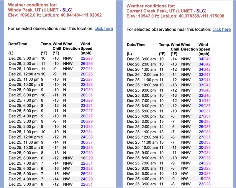
Nowcast- With clear skies overhead, a nearly full, Cold Moon, casts a beautifully illuminating light on our mountains this morning. While temperatures start the day shift in the teens and single digits, northerly winds earned a little extra holiday dough and worked though the weekend along the high ridges, racking up hourly averages in the mid and upper 30's.
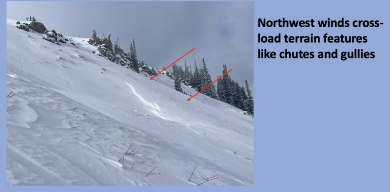
Forecast- After a sunny start to the day, clouds increase and a stray snow flurry or two isn't out of the question late this afternoon. Winds blowing in the 30's from the north and northwest are gonna be a nuisance near the high peaks. Temperatures climb into the mid 20's with overnight lows dipping into teens.
Futurecast- High pressure returns midweek, with another very weak system bumping through for Thursday. A few more minor impulses graze by over the weekend and into early next week, but don't get too excited... these look like meager snow producers at best.
Not much has changed since this snowpit image was captured at Gold Hill last week on a NW facing slope at 9800 ft.
Generally there's about two feet of snow in the Uinta's although you can find a few places at upper elevations with closer to three feet. There are three basic layers in the snowpack seen in the photo above with a few inches on top from Saturday's storm.
Recent Avalanches
No avalanches have been reported in the Uintas. There have been just a few small wind slabs triggered by ski patrols in the Wasatch.
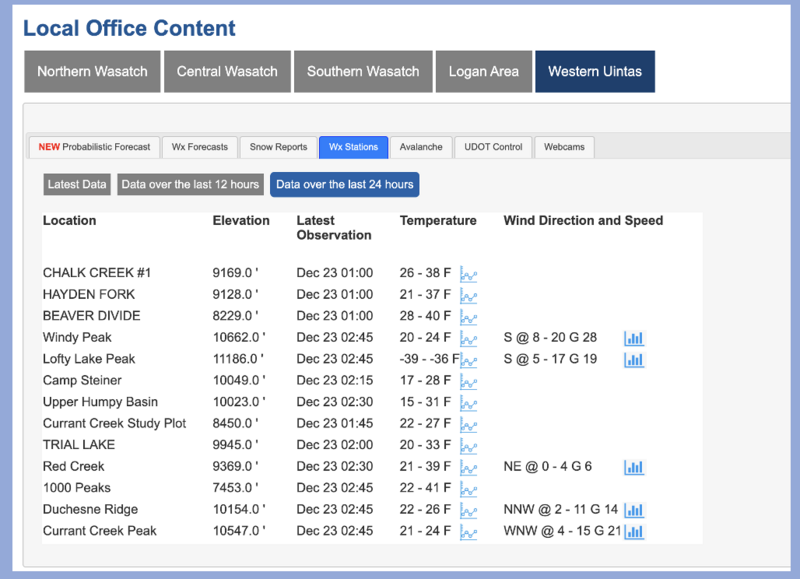
Trip reports and the latest observations are found HERE.
Ad
Avalanche Problem #1
Wind Drifted Snow
Type
Location
Likelihood
Size
Description
Along the high ridges, you can run, but you can't hide... a 24 hour data dump shows consistent north and northwest winds across the board and across the range.
A few inches of new snow from Saturday, conspired with recent winds, forming fresh drifts on the leeward side of ridges and terrain features like chutes and gullies. Over the weekend, I found the new, yet rather unreactive drifts on a quick trip for some turns at Wolf Creek Pass. Lose some elevation... lose the wind and you lose the problem.
Additional Information
Craig upgraded the Uinta weather station network this summer and all that real-time info is found HERE. Simply click on "western Uinta" tab and then "weather stations" tab.

We are always looking for snow and avalanche observations or just general riding conditions. So... if you see something, say something. You can reach me directly at [email protected] or 801-231-2170.
Also, if you're looking for more avy education opportunities for yourself, your crew, or your club please don't hesitate to reach out to me and we'll find a presentation, class, or clinic for ya!
General Announcements

Issued at 0400 on Tuesday, December 26th this forecast will be updated by 0700 Wednesday, December 27th, 2023.
This forecast is from the U.S.D.A. Forest Service, which is solely responsible for its content. This forecast describes general avalanche conditions and local variations always occur.