Forecast for the Uintas Area Mountains

Craig Gordon
Issued by Craig Gordon for
Sunday, December 2, 2018
In the wind zone in mid and upper elevation terrain at and above treeline, especially on slopes facing the north half of the compass, the avalanche danger is CONSIDERABLE. Human triggered avalanches are LIKELY on any steep slope harboring old snow near the ground. Remember- triggering a slide that breaks to old snow will have severe consequences.
Lose the old snow... you lose the problem and the avalanche danger drops dramatically.
Low
Moderate
Considerable
High
Extreme
Learn how to read the forecast here
Weather and Snow
The last gasp of storminess moved overhead last night, laying down an inch or two of white, ultra light, cold smoke. Currently, skies are cloudy, winds are light and variable, blowing 10-15 mph along the high peaks, and temperatures are in the single digits. Riding and turning conditions improve with each little blast of snow. Average snow depths across the range are inching towards the 4' mark.
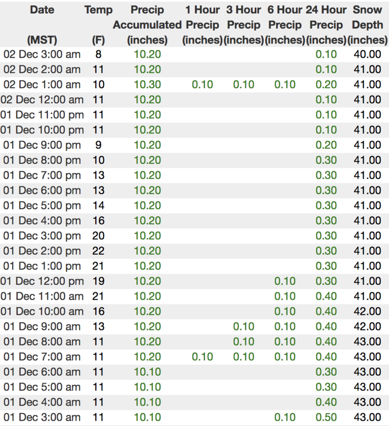
We are working to get the entire Uinta weather network back online. In the meantime, above is 24 hour data from Trail Lake (9945').
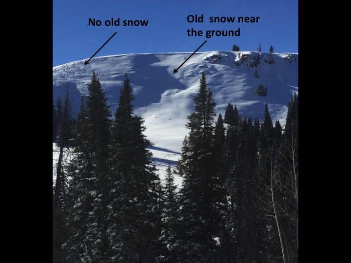
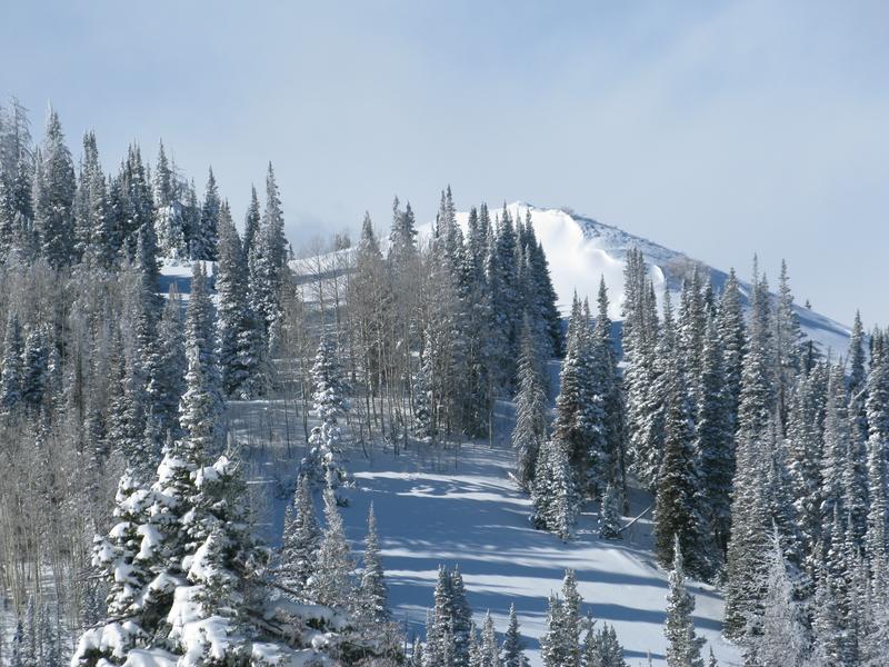
The image above clearly illustrates a savvy group that got their turns in while avoiding the avy hazard. Looks pretty straight-forward, but here's the problem... as snow stacks up and terrain terrain turns white, even slopes we're familiar with can appear uniform and small nuances in aspect can mean the difference between riding safely and triggering an avalanche. So here's your exit strategy.... just like the crew above, simply swing around to south facing slopes or lower elevation terrain which had no old snow prior to the big storm and you can ride without the worry of avalanches breaking to weak snow near the ground.
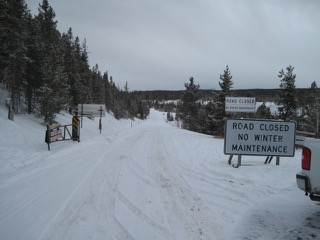
Plowing is done on Mirror Lake Highway, but Wolf Creek Pass is still open. However, just 'cause you can see your rig parked near Wolf Creek, doesn't mean the terrain you're choosing to ride is good to go.
Remember- this is the time of year where most of us get tricked thinking there isn't enough snow to avalanche. Unfortunately, this is also the type of setup when most close calls and accidents occur. If you are getting out and about, be prepared for your own self rescue. Wear and know how to use an avalanche beacon, shovel, and probe.
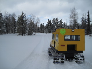
A happy cat realizes winter is finally here as the Mirror Lake Highway from the Evanston side of the range is closed.
Recent Avalanches
No new avalanche activity to report, but lots of collapsing still reported throughout the range.
Ad
Avalanche Problem #1
Persistent Weak Layer
Type
Location
Likelihood
Size
Description
The snowpack is slowly adjusting to this weeks storm snow and we haven't heard of or seen any recent avalanche activity in the past two days... that's good news. As a matter of fact, I bet there are plenty of slopes where you could ride today and not trigger an avalanche. But remember- our snowpack is still relatively shallow, its structure sketchy, and I consider it guilty until proven otherwise. Now here's where it gets tricky... as the pack gets stronger it lures us into steep terrain, often without incident, giving us a false sense of snowpack stability. However, all we need to do is find one weakness, maybe around a bush or rock that we can't see buried underneath the snow, collapse the pack, and now we're staring down the barrel of a scary avalanche. The way I'm avoiding this scerario is by simply avoiding the terrain where this setup exists.... mid and upper elevation, north facing slopes that harbored snow prior to the big Thanksgiving storm. Lose the old snow and you lose the problem.... done and done.
Weston D was in Smith-Moorehouse, Michael J stomped around the Weber Canyon environs. Their pit profiles are in the images above and their take on the current state of the state of the snowpack can be found here.
Avalanche Problem #2
Wind Drifted Snow
Type
Location
Likelihood
Size
Description
A few old wind drifts might still be sensitive to our additional weight. Found mostly on steep mid and upper elevation leeward slopes (like in the image above), as always, don't let your guard down. Be on the lookout for and avoid any fat, rounded piece of snow especially if it sounds hollow like a drum.
Additional Information
Light snow continues through the day with an additional couple inches stacking up, though it looks like the bulk of this storm is a little too far west and south of our zone. to make a substantial impact. Winds remain light and variable, blowing in the teens and low 20's along the high peaks. High temperatures climb into the teens and low 20's with overnight lows dipping into the single digits. Our next shot of snow is slated for midweek.
General Announcements
The information in this advisory expires 24 hours after the date and time posted, but will be updated by 7:00 AM Monday December 3rd, 2018.
If you're getting out and about, please let me know what you're seeing especially if you see or trigger and avalanche. I can be reached at [email protected] or 801-231-2170
It's also a good time to set up one of our very popular avalanche awareness classes. Reach out to me and I'll make it happen.
This information does not apply to developed ski areas or highways where avalanche control is normally done. This advisory is from the U.S.D.A. Forest Service, which is solely responsible for its content. This advisory describes general avalanche conditions and local variations always occur.