Forecast for the Uintas Area Mountains

Mark Staples
Issued by Mark Staples for
Monday, December 18, 2023
Today the avalanche danger is LOW on all aspects and elevations.
While great snow can be found in the Uintas, travel is still a bit limited. Consider doing some rescue practice with your partners.
Low
Moderate
Considerable
High
Extreme
Learn how to read the forecast here
Weather and Snow
It's really warm in the mountains, especially as we approach the winter solstice. Temperatures at the highest elevations are just under freezing, near treeline temperatures are in the mid to upper 30s F, and a few low spots have pools of colder air in the mid 20s F. Winds at ridgelines are averaging 15 mph gusting to 20 mph from the south.
With clouds moving over the area, skies will be partly sunny with temperatures climbing to the upper 30s and low 40s F. Winds should pick up this afternoon blowing steady 30 mph from the south.
While there's a chance for a few flurries tomorrow, the main action comes this weekend with a decent chance of snow on Saturday and very cold temperatures (near zero F) on Sunday.

Snow depths at weather stations range from 16-27 inches, but some areas at higher elevations have closer to three feet. South facing slopes have minimal snow that should be damp today. North facing slopes still have soft snow that is surprisingly supportable. It's worth getting out :)
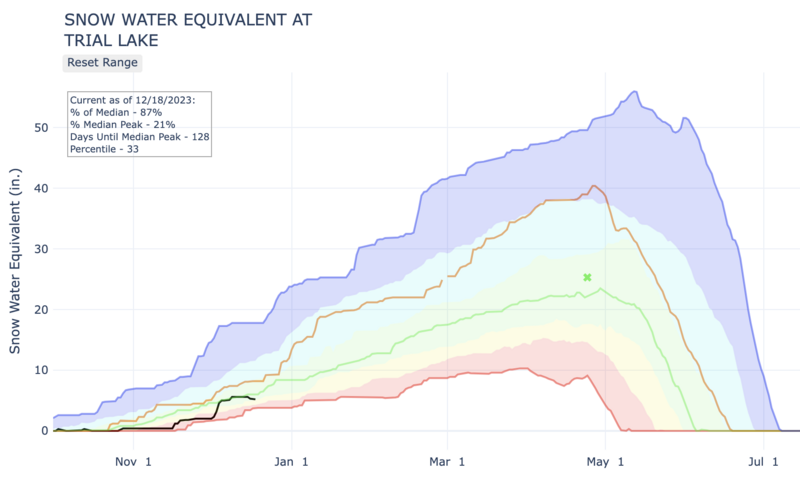
Below is a graph from the NRCS of precipitation at the Trial Lake SNOTEL site which has 24" snow (5.2" water). SNOTEL sites across the Uintas are reporting 60-100% of median values for snow water equivalent (SWE). (Green line = 30-year median, Brown line = last winter, Black line = this winter so far)
Recent Avalanches
There have been no reported avalanches in over a week.
Trip reports and the latest observations are found HERE.
Ad
Avalanche Problem #1
Normal Caution
Type
Location
Likelihood
Size
Description
There is plenty of weak snow near the bottom of the snowpack, but it has been sitting for over a week since the last storm, and the snowpack is mostly stable. The biggest concern is weakening of the snow surface on northerly facing slopes which could provide a new weak layer when snowfall builds a slab on top of it.
Even when the threat of avalanches is very small, it is not zero. This is why we carry rescue gear, travel with a partner, and only expose one person at a time.
Additional Information
Huge thanks to Rylan from Young Powersports for trusting me with the keys to the backcountry kingdom as well the keys to this 2023 Polaris. The decades old "loaner sled" partnership with Polaris allows me to see more terrain, issue more accurate forecasts, and ultimately saves lives! Note to self... always remember to grab the keys to the sled before leaving the dealer :)

We are always looking for snow and avalanche observations or just general riding conditions. So... if you see something, say something. You can reach me directly at [email protected] or 801-231-2170.
Also, if you're looking for more avy education opportunities for yourself, your crew, or your club please don't hesitate to reach out to me and we'll find a presentation, class, or clinic for ya!
General Announcements

Issued at 07:00 on Monday, December 18th this forecast will be updated by 0700 Tuesday, December 19th, 2023.
This forecast is from the U.S.D.A. Forest Service, which is solely responsible for its content. This forecast describes general avalanche conditions and local variations always occur.