Forecast for the Uintas Area Mountains

Craig Gordon
Issued by Craig Gordon for
Thursday, January 6, 2022
HEADS UP... WEIRD WEATHER IS MAKING WEIRD AVALANCHE CONDITIONS
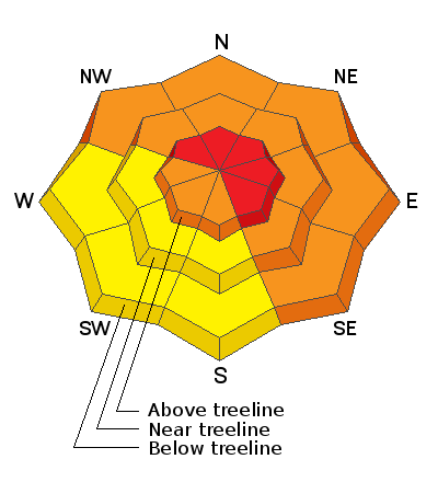
HIGH avalanche danger is found near and above treeline, especially in the wind zone. Triggering a deep, dangerous avalanche is VERY LIKELY, particularly on steep, wind drifted slopes facing the north half of the compass.
CONSIDERABLE avalanche danger exists at and below treeline where human triggered avalanches are LIKELY on steep, shady slopes.
The south half of the compass is slightly more straight-forward and you'll be dealing with mostly new snow issues. Look for MODERATE avalanche danger on steep slopes where human triggered avalanches are possible.

What's your exit strategy? There's no shortage of low angle, rolling terrain where you can steer clear of the avalanche dragon and still have a blast. Practice your riding technique and rip deep trenches in a big open meadow today, or head to low angle, sunny slopes that didn't have old October snow for some fun with limited avalanche danger. But remember- let's continue to give the steep, shady slopes some time to get comfortable in their new winter coats.
Low
Moderate
Considerable
High
Extreme
Learn how to read the forecast here
Avalanche Warning
AN AVALANCHE WARNING CONTINUES FOR THE MOUNTAINS OF NORTHERN AND CENTRAL UTAH, INCLUDING THE BEAR RIVER AND WASATCH RANGE, AND THE WESTERN UINTAS.
HEAVY DENSE SNOW ALONG WITH STRONG WINDS AND POTENTIAL FOR RAIN-ON-SNOW AT LOW ELEVATIONS WILL CREATE DANGEROUS AVALANCHE CONDITIONS AND A HIGH AVALANCHE DANGER.
NATURAL AND HUMAN-TRIGGERED AVALANCHES WILL BE LIKELY ON MANY ASPECTS AND ELEVATIONS.
Special Announcements
We are offering an Introduction to Avalanche Rescue Course for the Uinta Region, on January 12th at Nobletts Trailhead. This course is based on snow, practicing with your rescue equipment learning how to rescue a buried partner. With a small student to instructor ratios, we make sure that each student receives individual coaching and feedback on their technique and the opportunity to run through multiple scenarios. Register HERE
Weather and Snow
NOWCAST-
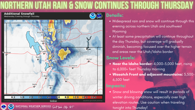
What a wild storm... a lot of blow, but disappointing amounts of storm snow. While water totals are impressive, clocking in at nearly an inch, snow totals are underwhelming with just 8"-10" reported at most locations. One exception to the rule is Hayden Fork which overproduces with 1.5" H2O and 14" snow. West and southwest winds don't discriminate, raging 60-80 mph for most of Wednesday, backing off slightly this morning and currently blow 40-60 mph. Temperatures have been rising through the night, currently registering in the mid 20's and low 30's. Riding and turning conditions have gone from hero to zero and it's a good day to get your chores done.
FORECAST-
Look for mostly cloudy skies with continued southwest winds screaming into the 70's along the high peaks, though they decrease as the day wares on. Temperatures hover in the 30's and another couple inches of dense, heavy snow stacks up throughout the day.
FUTURECAST-
A break in the action is slated for early Friday with a weak storm on tap for late in the day, lingering into early Saturday.

Looking for real-time temps, snow, or wind?
Click HERE and then on the "western Uinta" tab for western Uinta specific, weather station network.
Recent Avalanches
No recent significant avalanche activity to report from yesterday.

Click HERE for a list of recent avalanches.
A list of all other observations is found HERE

Your input is vital and we're interested in what you're seeing. Please contribute to this great community resource and go here to fill out an observation.
Ad
Avalanche Problem #1
Persistent Weak Layer
Type
Location
Likelihood
Size
Description
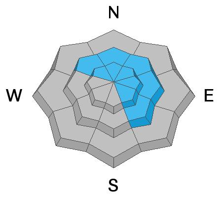
Lots of warm, dense heavy snow and big water numbers are a good thing for our snowpack in the long term, but in the short term this is a big thump to the junk in the trunk. In snow-geek-speak that's the persistent weak layer (PWL) of faceted snow near the ground. Sure, we're headed in the right direction, but the PWL hasn't miraculously healed overnight.
Here's where it gets tricky... while it's getting harder to trigger a deep, dangerous avalanche, we've gotta remember all the dense, heavy, wind driven snow, rests on top of a suspect foundation and the recent storm has the potential to bring these weak layers back to life. All we need to do is roll along and knock the legs out from underneath.
Here's where it gets dangerous-
  • Once triggered, avalanches may break hundreds of feet wide.
  • It may not be the first person on a slope that triggers A LARGE, DANGEROUS avalanche, it may be the second, third, fourth, etc. who triggers it.
  • Seeing tracks on a slope DOES NOT mean it's safe.
Slopes loaded by south winds are the exact ones where this weak layer exists. The addition of wind-drifted snow will make avalanches even larger, deeper, and more deadly.
Above, I explain what we're seeing on most low elevation slopes and south-facing terrain that had little or no snow prior to the big Christmas storm.
Avalanche Problem #2
Wind Drifted Snow
Type
Location
Likelihood
Size
Description
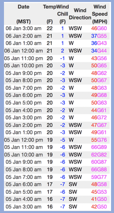
Above is a 24 hour data dump from Windy Peak (10,661')
West and southwest winds continue cranking near the ridges, forming fresh drifts along the leeward side of upper elevation ridges. Remember- strong winds often create drifts lower downslope than we anticipate and channel snow through terrain features. That said... I suspect drifts formed mid slope and around chutes and gullies. In any case, today we need to avoid steep, wind drifted terrain and remember even a small avalanche can have big consequences if it breaks into weaker layers of the snowpack as it crashes on the slope below.
Avalanche Problem #3
New Snow
Type
Location
Likelihood
Size
Description
If you're walking the dog, trail running, or headed out for a family snowshoe, think about avoiding steep, snow covered slopes and terrain traps like road cuts and river bottoms where even a small avalanche can produce a deep pile of debris. There's plenty of terrain with these characteristics above our mountain homes and in our foothills.
Additional Information
We installed the Transceiver Check station at Nobletts Trailhead this week... it's up and running and good to go. Of course, you want to check your partner before leaving the parking lot, but this is a good fail safe system to make sure everyone is sending a signal.
Your observations are important, so please let me know what you're seeing... click HERE and contribute to this amazing community based program
General Announcements
The information in this forecast expires 24 hours after the day and time posted, but will be updated by 07:00 Friday January 7th.
Before it gets too crazy, now is the time to book an avalanche awareness presentation for your group, club, or posse. You can reach me directly at 801-231-2170 or [email protected]
This forecast is from the U.S.D.A. Forest Service, which is solely responsible for its content. This forecast describes general avalanche conditions and local variations always occur.