UDOT PLANNED AVALANCHE CLOSURES!!

Forecast for the Uintas Area Mountains

Craig Gordon
Issued by Craig Gordon for
Wednesday, January 30, 2019
WE'VE DODGED A FEW BULLETS THIS PAST WEEK AND OUR LUCK IS RUNNING OUT.... DECEPTIVELY TRICKY AVALANCHE CONDITIONS CONTINUE ON THE EASTERN FRONT
In the wind zone at and above treeline, you'll find CONSIDERABLE avalanche danger. Human triggered avalanches are PROBABLE on all steep wind drifted slopes, especially those facing the north half of the compass and particularly those with an easterly component to their aspect. Any avalanche that breaks into deeper buried weak layers near the ground will result in a scary and very dangerous avalanche that will instantly ruin your day.
MODERATE avalanche danger exists on steep, mid elevation slopes facing the north half of the compass and human triggered avalanches are POSSIBLE.
Here's your exit strategy.... lower elevation, low angle terrain offers cold snow and a generally LOW avalanche danger.
Low
Moderate
Considerable
High
Extreme
Learn how to read the forecast here
Special Announcements
Weather and Snow
Under clear skies, temperatures are in the low to mid teens. Winds are northwesterly and light, blowing 15-25 mph along the high peaks. The snow surface could use a fresh coat of white paint, however amid the old tracks, wind board and sun funk, and with a little searching, you can still score soft creamy snow on wind sheltered, mid elevation slopes.
Above is hourly data from Trial Lake (9,945') and Windy Peak (10,662'). To view more regional weather stations click here.
Recent Avalanches
It's been a very busy week in the western Uinta's with a handful of large, snowmobile and skier triggered slides, resulting in a wrecked sled and few close calls that have experienced riders re-evaluating their terrain choices. Check out this viddy describing the decisions an experienced crew made based on current conditions.
Dave and Pete thumped this upper elevation, northwest facing slope yesterday, getting it to fail on early season facets and breaking 2'-4' deep and about 200' wide.
3' deep and 50' wide, this skier triggered pocket Tuesday near the Boundary Creek Yurt was smaller than recent human triggered slides. But you can clearly see by the snapped timber, this avy was packing a punch and meant business.
4' feet deep and 500' wide, the slide above was triggered Sunday near Hoyt Peak. We are of course happy everyone came out unscathed, but we're running out of luck, and there's not many empty chambers left.
BUT WAIT... THERE'S EVEN MORE AVY ACTIVITY FOUND HERE.
Ad
Avalanche Problem #1
Persistent Weak Layer
Type
Location
Likelihood
Size
Description
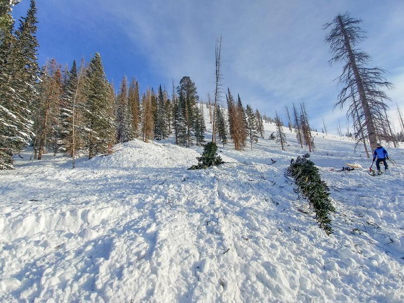
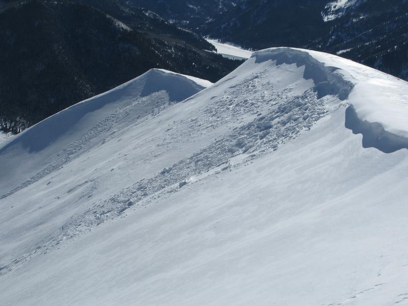
This snowmobile triggered slide in the image above from a week ago in Upper Moffit Basin, is the type of avalanche dragon we're dealing with. Once initiated, any avalanche that breaks into deeper buried weak layers in the pack will quickly get out of hand.
Great work by these two men-
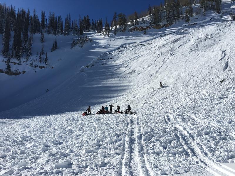
Over the weekend, Bo and Andy rode out of Chalk Creek and visited Friday's, Humpy Creek, sled triggered avalanche. They have a most excellent trip report and snowpack evaluation, which is found here. And below is their take on persistent slabs, stability, and riding habits.
"A Persistent Slab Avalanche problem should make you pay attention and approach slopes with caution. Avalanches are breaking 2'-6' feet deep and hundreds of feet wide throughout the Uinta Range. Last weeks storms and wind events added a significant load of snow that stressed weak layers in our snowpack. Some slopes avalanched naturally early last week- during the storm, other slopes are hanging in balance waiting to be triggered. With a Persistent Slab Avalanche problem, it is unlikely that you will experience any obvious signs of instability while out riding (such as collapsing or cracking) The most important thing to pay attention to is the fact that there have been multiple human-triggered avalanches over the past 3 days throughout the range."
BOOM... NAILED IT!
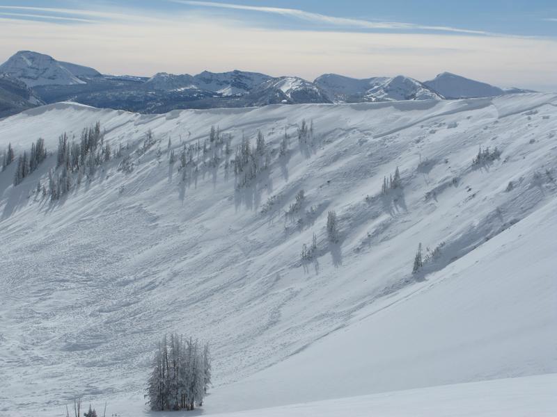
Yes... we're dealing with a much different avalanche problem than we usually see in the western Uinta's and because of the snowpack structure (strong snow on a thin layer of weak, sugary snow) you don't have to be climbing a slope in order to trigger a large slide. As a matter of fact, with all the recent avalanche activity we're seeing, here's the common theme.... riders are knocking the legs out from underneath the slab and avalanches are getting triggered from low on the slope, in relatively low angle angle terrain. This puts us in a dangerous position on the slope and right in the avalanche cross hairs. So even if we're playing in low angle terrain we need to look around a see if we're connected to steep terrain above or adjacent to where we're riding. We've had multiple near misses and a few close calls this week, and here's the reality.... it's just a matter of time before we run out of luck.
It doesn't mean we can't ride, but it's tricky out there and here's why. Many steep slopes throughout the range experienced a widespread natural avalanche cycle late last week, but recent snow and wind has filled in much of that evidence. So today it's all gonna look white and that's the challenge. You can ride some slopes without incident (perhaps they already slid) and think you're good to go, while an adjacent slope that remained intact throughout the storm, is just waiting for a trigger like us to roll up and tip the balance.
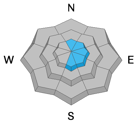
Of course you wanna know... "how do we manage an unmanageable avalanche?" Well with all the great riding out there and plenty of alternative options, we simply avoid the terrain where it exists. You know the drill by now.... steep, rocky, wind drifted slopes, especially those facing the north half of the compass. Listen to this groups decision making process here.
This viddy clearly illustrates our current setup. Bo and Andy commented, "In some test pits it was very easy to initiate failures and in others, it was more difficult. The common theme among all of the tests was that they were breaking deep in the snowpack on old snow. This tells me that in some areas, the avalanches might be less sensitive to trigger but if you trigger an avalanche it will break deep."
Avalanche Problem #2
Wind Drifted Snow
Type
Location
Likelihood
Size
Description
As you know the Uinta's are a big place and there always seems to be a terrain driven slab or two lurking along the leeward side of an upper elevation ridgeline. Today you'll want to continue utilizing all the awareness tools in your quiver. Look for obvious clues to unstable snow like shooting cracks out in front of our skis, board, or sled. Also remember to avoid any fat, rounded piece of snow especially if it sounds hollow like a drum. And finally the hugest clue... recent avalanches on the same kind of terrain you want to ride on.
A recently windloaded, upper elevation northeast facing slope, reacted to my additional weight yesterday. Not particularly large, but gives me a baseline to the type of terrain I wanna ride.
Additional Information
High pressure aloft gives us mostly sunny skies with temperatures climbing into the mid 30's. West and northwest winds remain predictably relaxed and blow in the teens and low 20's. Similar weather is on tap for Thursday. A change in the pattern begins late Friday and lingers through the weekend. A series of storms lined up in the Pacific should bring unsettled weather and a good shot of snow, though timing and details are still being sorted through. Stay tuned for more details coming in the next few days.
General Announcements
The information in this advisory expires 24 hours after the date and time posted, but will be updated by 7:00 AM Thursday January 31st, 2019.
If you're getting out and about, please let me know what you're seeing especially if you see or trigger and avalanche. I can be reached at [email protected] or 801-231-2170
It's also a good time to set up one of our very popular avalanche awareness classes. Reach out to me and I'll make it happen.
This information does not apply to developed ski areas or highways where avalanche control is normally done. This advisory is from the U.S.D.A. Forest Service, which is solely responsible for its content. This advisory describes general avalanche conditions and local variations always occur.