March Kicks Off Our Spring Campaign- Donate Now to Support Forecasting

Forecast for the Uintas Area Mountains

Mark Staples
Issued by Mark Staples on
Thursday morning, January 28, 2021
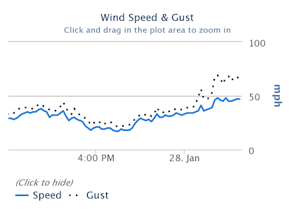
HEADS UP - Very strong winds have created dangerous avalanche conditions
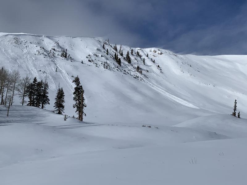
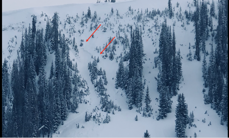
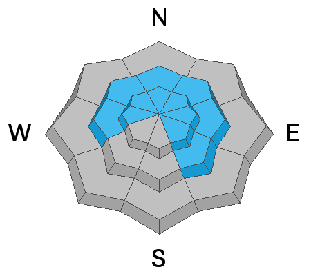
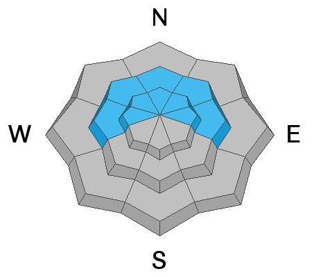
Near and above treeline today on slopes facing west, north, and east the avalanche danger is CONSIDERABLE. Avalanches will break in the wind drifted snow or break deeper into older layers of faceted snow. You may not see natural avalanches but HUMAN TRIGGERED AVALANCHES ARE LIKELY. You can trigger avalanches by simply being under or near steep slopes.

All other terrain has a MODERATE avalanche danger. Very few slopes will be unaffected by today's strong winds.

There is plenty of great terrain in the Uintas that is less than 30 degrees in steepness where avalanches generally don't happen as long as nothing steeper is above you.
Low
Moderate
Considerable
High
Extreme
Learn how to read the forecast here
Special Avalanche Bulletin
THE UTAH AVALANCHE CENTER HAS ISSUED A SPECIAL AVALANCHE BULLETIFROM 6 AM MST THIS MORNING TO 6 AM MST FRIDAY
FOR THE MOUNTAINS OF NORTHERN UTAH INCLUDING THE WASATCH RANGE...BEAR RIVER RANGE...UINTA MOUNTAINS.
DANGEROUS AVALANCHE CONDITIONS EXIST.
Special Announcements
Thanks to the generous support of our local resorts, Ski Utah, and Backcountry, discount lift tickets are now available HERE. Support the UAC while you ski at the resorts this season.
Weather and Snow
Nowcast-
Very strong winds from the south and southeast started early yesterday morning (graph below) and drifted a lot of snow yesterday. This morning they are blowing 30-50 mph gusting 45-70 mph at the high peaks especially on the northern end of the range. Temperatures this morning range from the low to upper teens F. Most places received an inch or two of snow with some areas getting up to 6 inches but it is hard to tell with such strong winds scouring snow on some slopes and drifting it onto others.
Forecast-
Southerly winds will continue ripping over the western Uintas today averaging 20-40 mph in most places with much stronger winds gusting to 70 mph at upper elevations. A few more inches of snow are possible today and temperatures should climb into the low 20s F.
Futurecast-
Drier air arrives this afternoon through Friday. Snowfall should return Friday night through Saturday afternoon bringing 2-4 inches followed by some sunshine on Sunday and Monday. A little more snow is possible starting Tuesday.

The graph below shows winds from Lofty Peak at 11,186 ft increasing yesterday with gusts reaching 70 mph this morning.
Looking for real-time temps, snow, or wind?
Click here and then on the "western Uinta" tab for western Uinta specific, weather station network.
Recent Avalanches
Several avalanches of wind drifted snow happened in upper Weber Canyon. They were likely triggered by a piece of falling cornice. One of these winds slabs caused an avalanche to break deeper into deeper layers of the snowpack on the lower part of the (photo D. Kikkert).
Another slide was seen a little further east that happened naturally.
Check in here for recent trip reports and avalanche observations.
Ad
Avalanche Problem #1
Persistent Weak Layer
Type
Location
Likelihood
Size
Description
The snowpack is teetering near its breaking point with multiple persistent weak layers of faceted snow under a slab of new snow and wind drifted snow. Southerly winds have made the situation worse by loading north facing slopes and cross loading east and west facing slopes.
Most slopes are waiting for a trigger like a person or a falling cornice which will likely trigger an avalanche today.
The strategty to avoid these avalanches is to avoid avalanche terrain. Regular observer JG with decades of Uinta experience put it best in his recent ob "I have a low tolerance for risk based on our snowpack setup so I'm going to continue to avoid terrain 30° and steeper. "
Video describing how you can trigger avalanches from below.
Avalanche Problem #2
Wind Drifted Snow
Type
Location
Likelihood
Size
Description
Craig was in the Chalk Creek area yesterday (video below) and observed winds from the south and southeast drifting snow onto many slopes. With such strong winds, nearly all slopes above and near treeline have been affected. Even slopes well below treeline have likely been affected by winds.
These slabs of wind drifted snow will continue growing today and be easy to trigger. They can also cause an avalanche to break deeper into old snow layers of faceted snow and cause a bigger avalanche.
Additional Information
I will update this forecast by 7:00 AM tomorrow, Friday January 29th.
Your observations are import, so please let me know what you're seeing... click HERE and contribute to this amazing community based program
General Announcements
If you see or trigger an avalanche or just wanna let me know what you're seeing you can reach me directly at 801-231-2170 or [email protected]
This forecast is from the U.S.D.A. Forest Service, which is solely responsible for its content. This forecast describes general avalanche conditions and local variations always occur.