Forecast for the Uintas Area Mountains

Craig Gordon
Issued by Craig Gordon for
Thursday, January 25, 2024
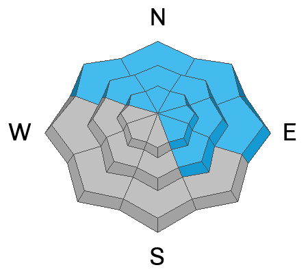
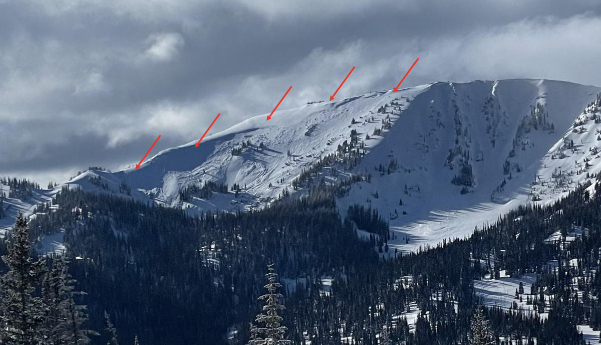
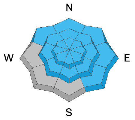
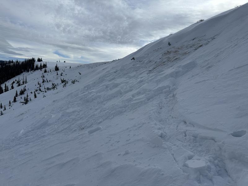
At and above treeline CONSIDERABLE avalanche danger exists on all slopes, but particularly those facing the north half of the compass. Human triggered avalanches are LIKELY in wind drifted terrain, especially steep, rocky slopes in the wind zone with an easterly component to their aspect. Any slide you trigger today has the potential to break deeper and wider than you might expect... instantly ruining your day.
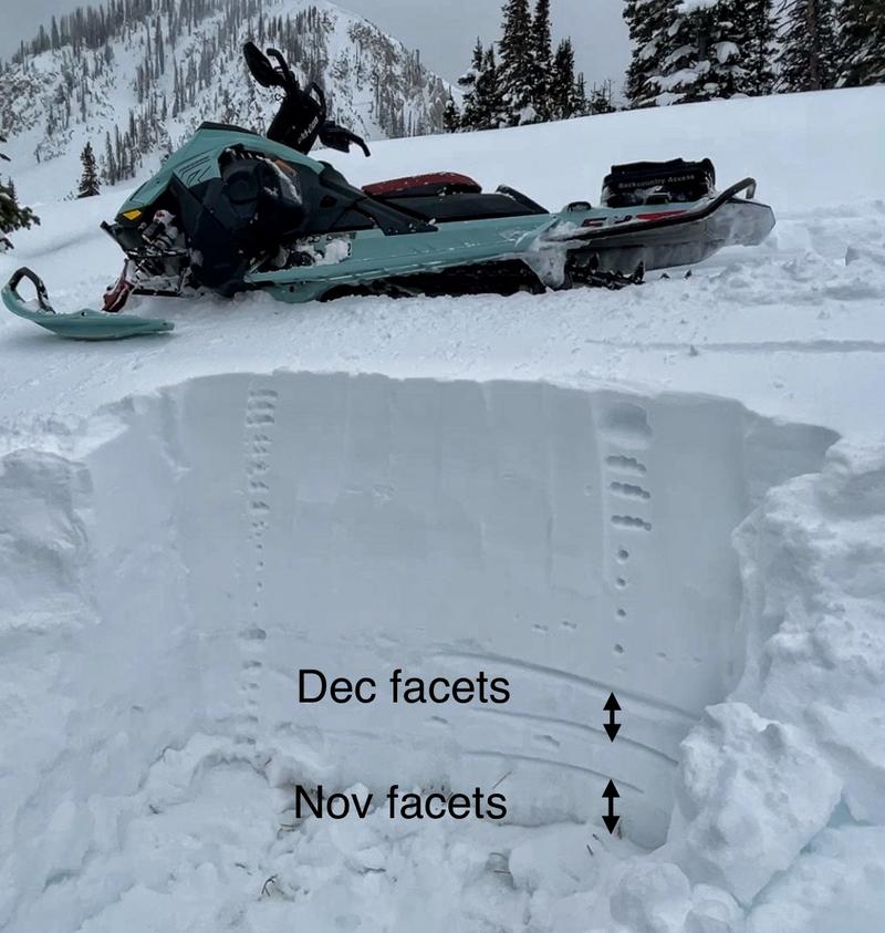
Look for MODERATE avalanche danger on mid elevation slopes near treeline facing west, southwest, and south, but also on lower elevation shady slopes as well. In either case, dense snow rests on weak, sugary snow and human triggered avalanche are POSSIBLE.
There are plenty of low angle options out there to avoid avy danger yet still get some great riding. It's simple, just steer your snow vehicle towards lower elevation terrain facing the south half of the compass where you'll find LOW avalanche danger and human triggered avalanches are UNLIKELY.
Low
Moderate
Considerable
High
Extreme
Learn how to read the forecast here
Special Announcements
Recent storms delivered unprecedented avy conditions and Extreme danger for the mountains of Northern Utah. Wondering how we got there and where we're going? Well then... you came to the right place!
Please join Craig Gordon (that's me :) this Thursday, January 25th from 6:00-7:30 for a State of the Snowpack presentation at Alpha Coffee's Big Cottonwood Canyon location- 7260 Racquet Club Dr, Cottonwood Heights, UT 84121
Weather and Snow
Nowcast- A big, bright, beautiful, full Wolf Moon peaks out from mostly cloudy skies draping our mountains this morning while a band of moisture to our west is on the doorstep and should roll though the region right around sunrise. Temperatures dipped into the mid teens overnight and winds blowing from the southwest bumped into the low 20's right around the turn of the new day. Riding and turning conditions greatly improved with Tuesday nights shallow, yet dense coat of white paint and I suspect it'll only get better with today's shot of snow.
Forecast- Not a days-long, prolonged powder party, but a nice trickle of snow develops in the next few hours. Temperatures climb into the mid 20's and winds blow from the west in the 20's and 30's near the high peaks. Snow stacks up in earnest through early afternoon before tapering off later today. Storm totals look like they'll register in the 6"-10" range.
Futurecast- A few snow showers linger into Friday morning, but in general we dry out as high pressure brings clearing skies through the weekend.

The snowpack grew by leaps and bounds since the big January 13th storm roared into town, delivering collosal amounts of snow and Herculean water content. The Uintas are white with settled snow depths averaging of 3-4 feet and some high elevation snowbelt zones registering just over 5 feet. The image above on a northeast facing slope at 9,800' illustrates our current setup. Soft powder on the surface, a hard/dense layer which is the big January storm snow, resting on several layers of facets that you won't know exist unless you dig into the snow and Snoop (dog) around.
Snow summary from NRCS SNOTEL sites:
Chalk Creek #1 (9,171') - 49" snow depth (10.7" total water)
Trial Lake (9,992') - 57" snow depth (10.7" total water)
Wolf Creek Peak (9,796') - 40" snow depth (8.7" total water)
Currant Creek (7,915') - 29" snow depth (6.6" total water)
Daniels-Strawberry (8,008') - 36" snow depth (8.8" total water)
Strawberry Divide (8,123') - 44" snow depth (11.3" total water)
Recent Avalanches
Mark and Weston D discovered this very large avalanche in the Moffit Drainage yesterday. Westin provides the narrative and a blow by blow description of this impressive slide.
More recent avy activity-

Read more Uinta observations and avalanches HERE.
Ad
Avalanche Problem #1
Persistent Weak Layer
Type
Location
Likelihood
Size
Description
Averaging 3.5' deep and 1,500' wide, this is an impressive piece of snow, wrapping around the entire east face of Moffit Bowl. The jury is deliberating on the trigger, but it appears the slide occurred Saturday or Sunday (Jan 20 or 21).
Remember- the persistent layer of weak, sugary snow formed during the mid December dry spell hasn't gone away. In fact, it's now buried several feet deep and a very strong piece of snow, a slab, rests on top. And while the snowpack isn't nearly as active as just a few days ago when it reached its boiling point, we have to remember, it's still simmering. Sure, all the right ingredients have to blend together to trigger a slide today, but just like Emeril in the kitchen, when it all comes together... Bam!... your goose is cooked and you'll be staring down the barrel of a very dangerous avalanche. (disclaimer... no geese were injured or cooked in the making of this metaphor :)
Triggering a slab avalanche on the now buried mid-December drought layer remains likely, especially if you collapse (whoomph) a slope near a thin area of snow (like around a buried rock, boulder, or bushes barely covered with a thin facade of snow).
Avalanche Problem #2
Wind Drifted Snow
Type
Location
Likelihood
Size
Description
As today's storm materializes and new snow stacks up, winds will have something to work with and will whip up fresh wind drifts reactive to our additional weight. And while more the exception than the rule, even a small wind drift can break deeper and wider as it crashes down on the slope below. A good rule of thumb is to simply avoid steep, wind drifted, leeward slopes, especially if they appear fat and rounded or sound hollow like a drum.
A good example is this wind slab, intentionally triggered by a couple of skiers this weekend near Wolf Creek Pass (photo - Park and Shirey).
Additional Information
The Uinta weather station network was upgraded this summer and all that real-time info is found HERE. Simply click on "western Uinta" tab and then "weather stations" tab.

We are always looking for snow and avalanche observations or just general riding conditions. So... if you see something, say something. You can reach me directly at [email protected] or 801-231-2170.
Also, if you're looking for more avy education opportunities for yourself, your crew, or your club please don't hesitate to reach out to me and we'll find a presentation, class, or clinic for ya!
General Announcements

Issued at 0430 on Thursday, January 25th this forecast will be updated by 0700 Friday, January 26th, 2024.
This forecast is from the U.S.D.A. Forest Service, which is solely responsible for its content. This forecast describes general avalanche conditions and local variations always occur.