Forecast for the Uintas Area Mountains

Mark Staples
Issued by Mark Staples for
Monday, January 22, 2024
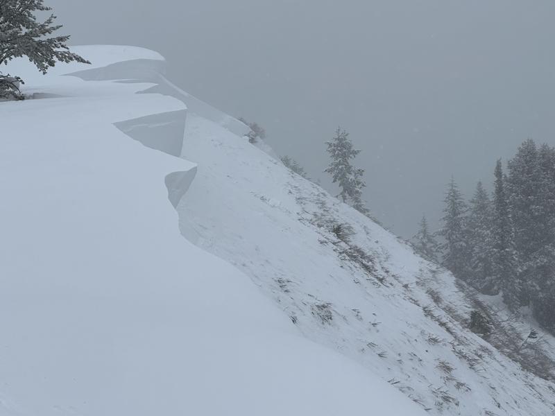
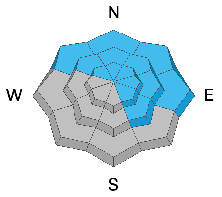
The avalanche danger is CONSIDERABLE on all slopes above treeline as well as all other slopes facing northwest, north, northeast, east, and even southeast.
The avalanche danger is MODERATE on slopes near and below treeline facing west, southwest, and south where human triggered slides are possible.
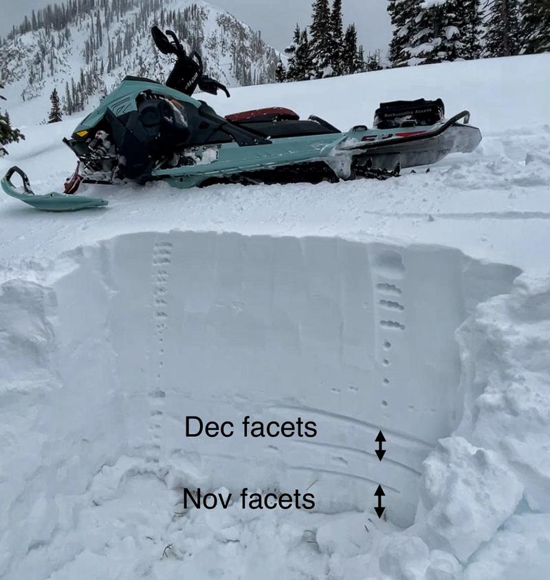
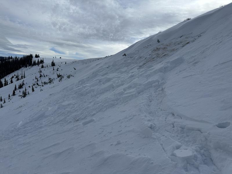
There's a lot of great snow and great riding in the Uintas now. Don't let the snowpack fool you into thinking it's safe because it's not. The signs of danger won't be obvious but know that very weak snow is lurking under your feet or track.
Low
Moderate
Considerable
High
Extreme
Learn how to read the forecast here
Weather and Snow
This morning there's maybe an inch of new snow in the Strawberry Reservoir area. Temperatures range from the low to high 20s F. Light winds at the highest elevations are only blowing 10 mph from the south.
Today will be mostly cloudy with some sunshine appearing. Temperatures should warm a little but mostly stay in the upper 20s F, and winds remain light.
This week will have cloudy skies and a trace of snow here and there as well as the Chiefs winning the AFC Championship game next weekend :) Perhaps a few inches could fall on Thursday, and then the weekend should be sunny. Temps remain cool through the week.

The snowpack has gotten deeper and gained a lot of water since Jan 4th with settled snow depths of 3-4 feet and even 5-6 feet at higher elevations. Since that time, it has also been very windy (even in sheltered areas). Unfortunately, a widespread layer of very weak faceted snow was buried on Jan 4th and we'll be dealing with this layer for some time.
Photo below shows soft powder on top, a hard/dense layer of snow, then several layers of facets that you won't know are there unless you dig into the snow. (NE facing at 9800')
Snow summary from NRCS SNOTEL sites:
Chalk Creek #1 (9,171') - 49" snow depth (10.7" total water)
Trial Lake (9,992') - 57" snow depth (10.7" total water)
Wolf Creek Peak (9,796') - 40" snow depth (8.7" total water)
Currant Creek (7,915') - 29" snow depth (6.6" total water)
Daniels-Strawberry (8,008') - 36" snow depth (8.8" total water)
Strawberry Divide (8,123') - 44" snow depth (11.3" total water)
Recent Avalanches
Even though avalanche activity has eased, they keep happening, and the snowpack is talking to us. While riding with Summit County SAR yesterday, I still felt a few collapses mainly as my sled rode over thinner areas of snow. A group on Saturday reported collapsing happening all day long.

Read more Uinta observations and avalanches HERE.
Ad
Avalanche Problem #1
Persistent Weak Layer
Type
Location
Likelihood
Size
Description
The persistent weak layer formed on the snow surface during dry weather in December hasn't gone away. It is buried 2-3 ft deep and remains weak. What makes things tricky is that the danger isn't obvious now and the snowpack is very supportable (meaning - you won't sink into the weak layer).
Triggering a slab avalanche on this layer remains likely, and you can trigger one from the bottom of a slope especially if you ride near a thinner area of snow (like over a buried rock or boulder that is unseen).
Avalanche Problem #2
Wind Drifted Snow
Type
Location
Likelihood
Size
Description
Even though winds have been light the last two days, winds have blown from all directions last week and reached into normally sheltered areas. Slabs of wind drifted snow are resting on a persistent weak layer discussed above and will remain easy to trigger. In other places like south facing slopes, these wind slabs should be stabilizing. A good example is a wind slab skiers intentionally triggered yesterday near Wolf Creek Pass on Saturday (photo below - Park and Shirey).
Additional Information
The Uinta weather station network was upgraded this summer and all that real-time info is found HERE. Simply click on "western Uinta" tab and then "weather stations" tab.

We are always looking for snow and avalanche observations or just general riding conditions. So... if you see something, say something. You can reach me directly at [email protected] or 801-231-2170.
Also, if you're looking for more avy education opportunities for yourself, your crew, or your club please don't hesitate to reach out to me and we'll find a presentation, class, or clinic for ya!
General Announcements

Issued at 0700 on Monday, January 22nd this forecast will be updated by 0700 Tuesday, January 23nd, 2024.
This forecast is from the U.S.D.A. Forest Service, which is solely responsible for its content. This forecast describes general avalanche conditions and local variations always occur.