Forecast for the Uintas Area Mountains

Mark Staples
Issued by Mark Staples for
Sunday, January 21, 2024
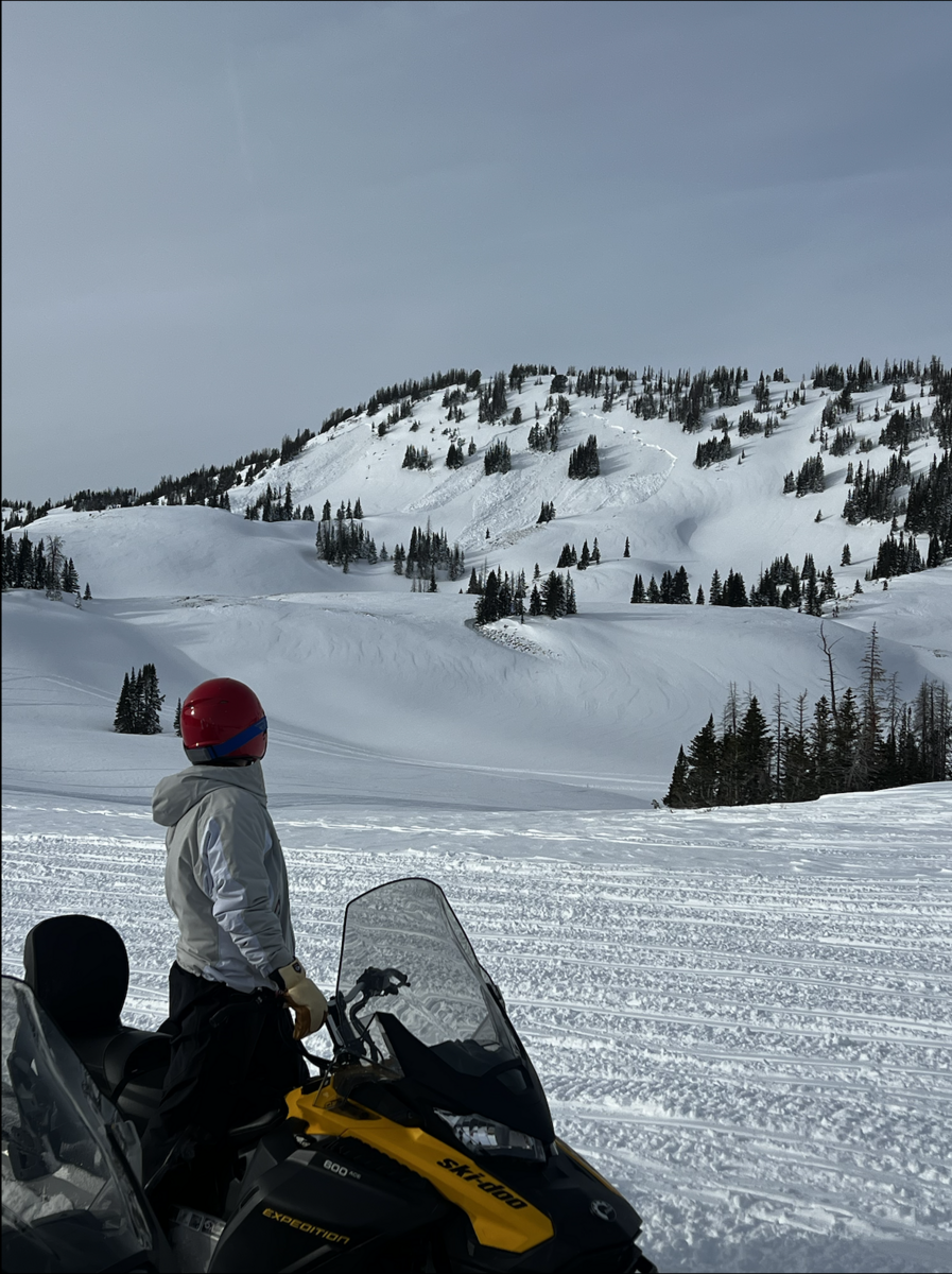
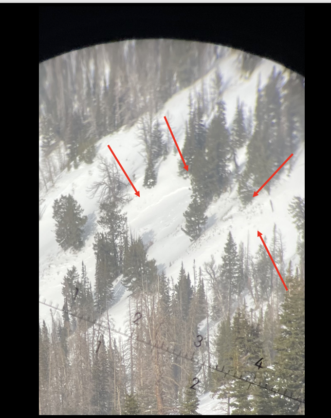
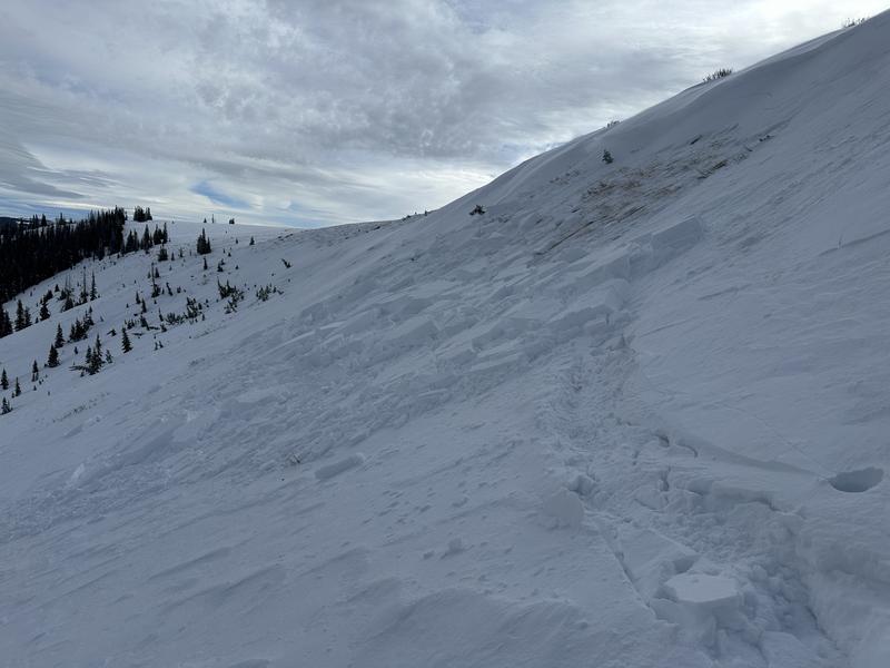
The snowpack is still teetering and only needs a person to tip it over the edge and trigger an avalanche. A buried persistent weak layer of facets exists on more slopes than not and has been responsible for widespread avalanche activity. Don't mess with this layer.
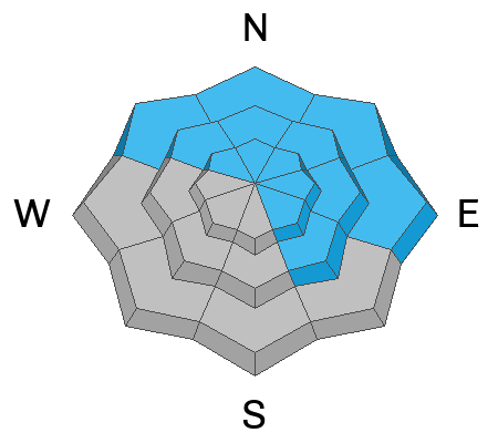
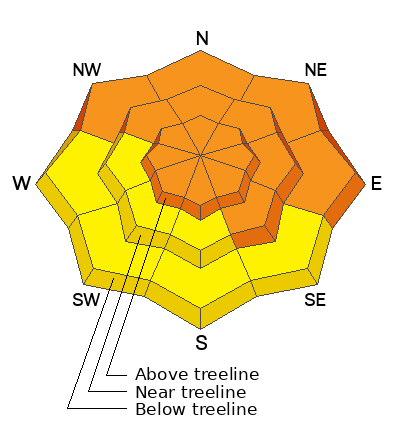
Human triggered avalanches are likely and the avalanche danger is CONSIDERABLE on all slopes above treeline as well as all other slopes facing northwest, north, northeast, east, and even southeast.
The avalanche danger is MODERATE on slopes near and below treeline facing west, southwest, and south where human triggered slides are possible.
Low
Moderate
Considerable
High
Extreme
Learn how to read the forecast here
Weather and Snow
This morning there's a trace of snow from yesterday. Temperatures are in the mid to upper 20s F. Winds are tame. At upper elevations, winds are blowing 10-17 mph gusting to 25 mph from the south. However, winds from the south blew stronger yesterday and transported snow.
Today another 1-3 inches of snow should fall during the middle of the day. It'll be warm with temperatures rising to near 30 degrees F, and winds will be light.
The weather pattern ahead remains active. No major storms are lined up, but no big ridges of high pressure are lined up either.

The snowpack has gotten deeper and gained a lot of water since Jan 4th with settled snow depths of 3-4 feet ,and even 5-6 feet at higher elevations. Since that time it has also been very windy (even in sheltered areas). Snow coverage is highly variable, and you'll find many slopes scoured and many drifted. Unfortunately, a widespread layer of very weak faceted snow was buried on Jan 4th and we'll be dealing with this layer for some time.
Snow summary from NRCS SNOTEL sites:
Chalk Creek #1 (9,171') - 49" snow depth (10.7" total water)
Trial Lake (9,992') - 57" snow depth (10.7" total water)
Wolf Creek Peak (9,796') - 40" snow depth (8.7" total water)
Currant Creek (7,915') - 29" snow depth (6.6" total water)
Daniels-Strawberry (8,008') - 36" snow depth (8.8" total water)
Strawberry Divide (8,123') - 44" snow depth (11.3" total water)
Recent Avalanches
AVALANCHES CONTINUE. A group of riders yesterday reported continuous collapsing which is an avalanche except on a low angle slope so the snow doesn't release. You may not hear or feel these collapses while riding a snowmobile, but you may see saplings and tree limbs shake when the collapses happens.
Photo - naturally triggered slide in upper Humpy Basin (Bayou Dave)

Read more Uinta observations and avalanches HERE.
Ad
Avalanche Problem #1
Persistent Weak Layer
Type
Location
Likelihood
Size
Description
The persistent weak layer formed on the snow surface during dry weather in December hasn't gone away. It remains weak, and it continues to produce avalanches and large collapses. Snow depths are highly variable, but you can generally find this layer under several feet of snow about 2/3 of the way down into the snowpack.
Triggering a slab avalanche on this layer remains likely, and you can trigger one from the bottom of a slope. This layer also exists at low elevations as a group hiking up Slate Creek found yesterday when they spotted this slide a few days old.
Yesterday Craig spotted this avalanche triggered by snowmobilers low on the slope.
Avalanche Problem #2
Wind Drifted Snow
Type
Location
Likelihood
Size
Description
Slabs of wind drifted snow exist all over the map. Some are easy to see while some formed last week and are now buried. In many cases, these wind slabs rest on the PWL discussed above. In other cases, more recently formed wind slabs rest on a variety of other surfaces and can be triggered like one skiers intentionally triggered yesterday near Wolf Creek Pass (photo below - Park and Shirey). The most likely places to trigger wind slabs today are at higher elevations or any place with the persistent weak layer underneath.
Additional Information
The Uinta weather station network was upgraded this summer and all that real-time info is found HERE. Simply click on "western Uinta" tab and then "weather stations" tab.

We are always looking for snow and avalanche observations or just general riding conditions. So... if you see something, say something. You can reach me directly at [email protected] or 801-231-2170.
Also, if you're looking for more avy education opportunities for yourself, your crew, or your club please don't hesitate to reach out to me and we'll find a presentation, class, or clinic for ya!
General Announcements

Issued at 0700 on Sunday, January 21st this forecast will be updated by 0700 Monday, January 22nd, 2024.
This forecast is from the U.S.D.A. Forest Service, which is solely responsible for its content. This forecast describes general avalanche conditions and local variations always occur.