Forecast for the Uintas Area Mountains

Craig Gordon
Issued by Craig Gordon for
Thursday, January 20, 2022
In general, you'll find LOW avalanche danger throughout the range and human triggered avalanches are unlikely. Remember... LOW danger... ain't NO DANGER, so if you're getting into steep, technical terrain, think about your exit strategy beforehand and have a plan prior to sending a big, committing line.

We're off to a great start and it's been a remarkable season so far! In fact, it's a rarity to have such a deep, supportable, and generally stable snowpack this early in the season.
Low
Moderate
Considerable
High
Extreme
Learn how to read the forecast here
Weather and Snow
NOWCAST-
Last nights weak storm delivered a few of traces of snow and cooler temperatures which register in the single digits across the board. West and northwest winds are light, blowing just 5-15 mph along the high ridges. On a go-anywhere base with a little new and recycled snow on top, it's a great day for exploring our remarkable backyard.
FORECAST-
Mostly sunny skies are on tap for a chunk of the day, with high temperatures climbing into the the low 30's. Clouds and wind increase as the day wares on and a short-lived shot of snow develops this evening. We might be able to squeak out 3"-6" by sunrise Friday.
FUTURECAST-
Snow showers linger through Friday morning with high pressure and sunny skies slated for the weekend.
Looking for real-time temps, snow, or wind?
Click HERE and then on the "western Uinta" tab for western Uinta specific, weather station network.
Recent Avalanches
No significant avalanche activity to report, but remember... today's loud powder is potentially tomorrows avalanche. Mark was in Soapstone yesterday and reports no shortage of weak, surface snow like in the image above. He's got a great trip report and brings decades of insight and experience to the setup moving forward.

Click HERE for a list of recent avalanches.
A list of all other observations is found HERE

Your input is vital and we're interested in what you're seeing. Please contribute to this great community resource and go here to fill out an observation.
Ad
Avalanche Problem #1
Persistent Weak Layer
Type
Location
Likelihood
Size
Description
Current state of the snowpack-
Wow... what a Uinta snowpack! It's taken a minute or two, but finally... our pack is deep, solid, and mostly stable. The big Christmas storm was the game changer not only with snow, but more importantly with big water numbers or what we call SWE... snow water equivalent. So, here's the setup- for a couple of weeks we received a tremendous amount of water weight, storm snow, and nuking winds and all this additional weight and stress was like parking a battleship on top of the weak, early season, sugary base. Yes... some terrain teetered on the edge of failure, some big slopes naturally avalanched, and others held tight. There were a few surprises early in the season, but fortunately everyone came out unscathed with a new found understanding of our snowpack structure.
The good news-
The pack is happy in its own skin, the Persistent Weak Layer (PWL) is trending towards dormancy, and it's time to slowly start stepping into big terrain. And while all the stability indicators align suggesting green light conditions, always take a moment and dip a toe into the water before diving head first. Start with mini golf terrain and see how it's reacting before pulling the trigger on a big, exposed, committing or technical line.
What to watch out for-
You'd have to go out of your way to trigger an avalanche today, but the usual suspects come to mind... upper elevation, rocky, alpine terrain above treeline. In other words... anywhere the pack is thin and weak, maybe around a bush or a rock we can't see barely covered over with snow. In terrain with these characteristics you can get an unwelcome surprise and still trigger a slide.
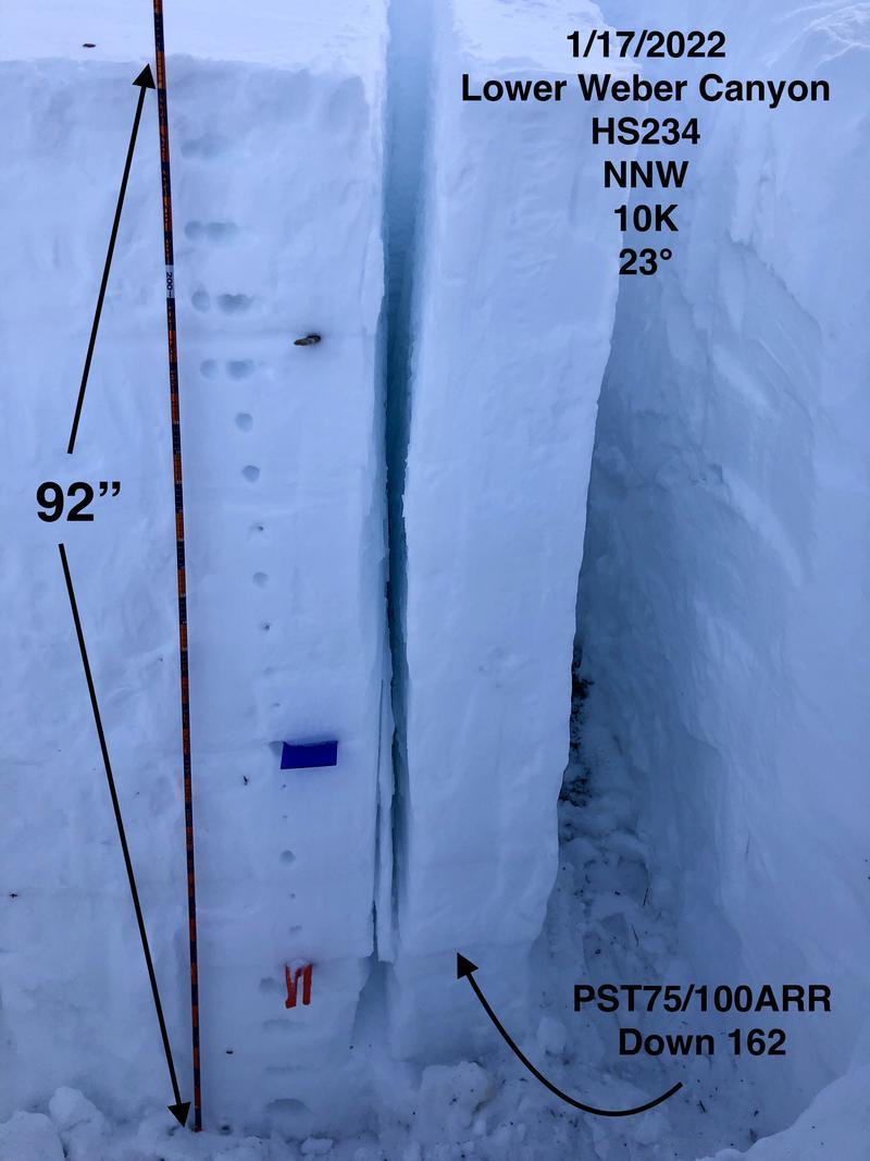
The intrepid JG was in the Hoyt environs earlier this week and scribed the homogenous layers of our amazingly strong snowpack in the image above. JG is a super-savvy backcountry rider that's been stomping around the Uinta's for decades and knows when it's time to pump the brakes on objectives and when it's time to hit the gas pedal. His encouraging take on the current state of the snowpack whilst grabbing a fist fulla' throttle is found HERE
Additional Information
Earlier this week, Ted installed the Beacon Basin training park at the Bear River Trailhead. Huge thanks to Dave Allen and the Monviso HOA for all the support making this potentially life saving resource available to our entire community.
Your observations are important, so please let me know what you're seeing... click HERE and contribute to this amazing community based program
General Announcements
The information in this forecast expires 24 hours after the day and time posted, but will be updated by 07:00 Friday January 21st.
Before it gets too crazy, now is the time to book an avalanche awareness presentation for your group, club, or posse. You can reach me directly at 801-231-2170 or [email protected]
This forecast is from the U.S.D.A. Forest Service, which is solely responsible for its content. This forecast describes general avalanche conditions and local variations always occur.