Forecast for the Uintas Area Mountains

Mark Staples
Issued by Mark Staples for
Friday, January 14, 2022
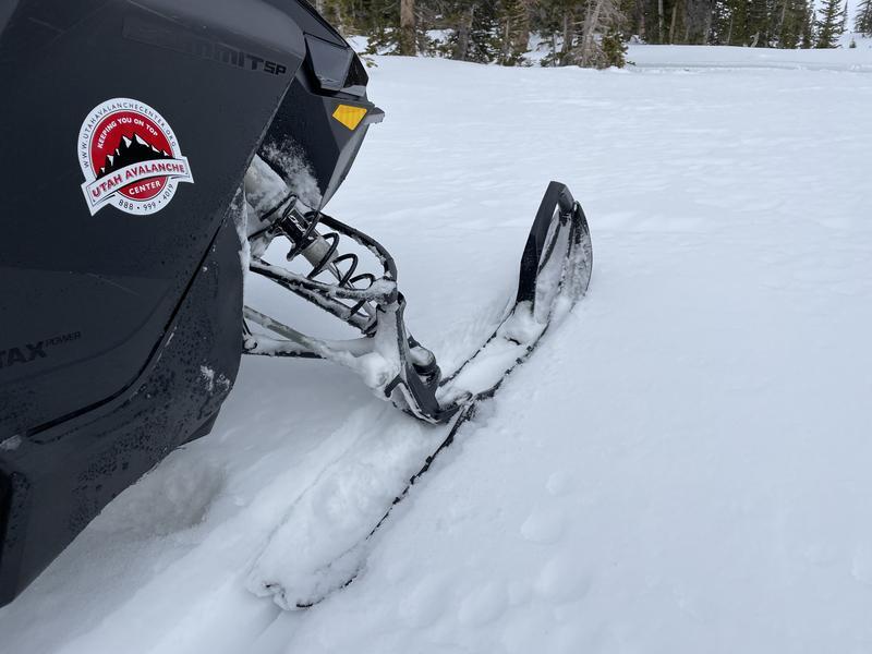
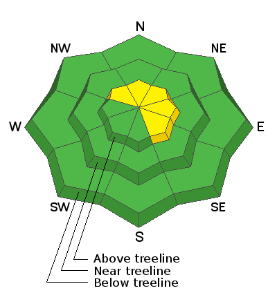
Triggering a very large avalanche remains possible above treeline, especially in steep, rocky terrain where the avalanche danger is MODERATE on slopes facing northwest, north, northeast as well as east and southeast. All other slopes have a LOW avalanche danger and triggering an avalanche is unlikely.

It has been a remarkable season, and we're incredibly lucky to have such a deep, supportable snowpack that is generally safe on many slopes. This situation is a rare thing most years in the Uintas. Many people have commented that conditions right now remind them of what we typically see in late February or March.
Low
Moderate
Considerable
High
Extreme
Learn how to read the forecast here
Weather and Snow
NOWCAST-
Overnight and yesterday winds blew from the south. Very early this morning winds began blowing from the north 10-15 mph gusting to 20 mph and delivered much colder air. At upper elevations, temperatures are in the mid to upper teens F (20 degrees colder than yesterday morning). Temperatures at trail heads are in the upper 20s F.
FORECAST-
Some clouds are moving over the area this morning and could drop a few snowflakes, but skies will clear by afternoon. Light winds will blow from the north bringing cold air. Temperatures may drop a few more degrees this morning but will be offset by warm sunshine this afternoon. High temperatures at upper elevations should reach the low to mid 20s F.
FUTURECAST-
High pressure, dry weather, and sunshine are in the forecast for some time. No snowfall is expected in the next week.
Despite no snowfall in the last week, the snow remains soft and cold on many slopes in the Uintas. Southerly facing slopes should have a melt/freeze ice crust on them, but most other slopes still have soft powder. It may not be deep but it's still soft and fun with easy riding and easy skiing/trail breaking.
Coverage is incredible for January 14th! Snow depths are about 3 feet at 8000 ft and at upper elevations snow depths are consistently 5-6 feet on all aspects.

Looking for real-time temps, snow, or wind?
Click HERE and then on the "western Uinta" tab for western Uinta specific, weather station network.
Recent Avalanches
The last reported avalanche in the Uintas was just over a week ago. It's been quiet since then.

Click HERE for a list of recent avalanches.
A list of all other observations is found HERE

Your input is vital and we're interested in what you're seeing. Please contribute to this great community resource and go here to fill out an observation.
Ad
Avalanche Problem #1
Persistent Weak Layer
Type
Location
Likelihood
Size
Description
Summary/history of the problem-
  • Snow fell in October & early November
  • Dry weather from early November to early December weakened and faceted that snow which became the "persistent weak layer"
  • That snow melted away on south facing slopes
  • Heavy snowfall in December buried that weak layer and caused avalanches on it
Current situation-
All the ingredients for an avalanche exists with a weak layer near the ground and a very thick, deep, and hard slab of snow on top of it (3-5' deep). What is lacking is the weight and stress from recent snowfall. The last snowfall was 6 days ago, and the last reported avalanches was 8 days ago.
The good news-
The weak layer has gained A LOT of strength, and it is hard to impact the weak layer which is buried so deeply. Triggering a slide on slopes with a deep, uniform snowpack is unlikely.
What to watch out for-
The weak layer is the weakest and easiest to impact in upper elevation, rocky, alpine terrain above treeline. These are places where snow depths are much more variable and the weak layer remains weak in isolated pockets. There is a possibility of triggering a slide in those locations.
Below is my video from yesterday on the north side of Notch Mountain. We found nearly identical conditions that Craig found further south the day before in this video.
A regular observer in upper Weber Canyon found similar conditions as well with a deep and strong snowpack that is giving us more and more confidence to start stepping out into avalanche terrain.
*ALSO of note - As Craig found yesterday in upper Weber Canyon, slopes that previously avalanched sometimes become future problems (repeaters) but most of them slid during December storms and immediately refilled with snow. For that reason, they have a slightly shallower snowpack, but the weak layer has become stronger on those slopes just like on ones that didn't slide.
Additional Information
Yesterday, we installed the Beacon Basin training park at Nobletts Trailhead. Huge thanks to Wasatch and Summit County SAR, along with BCI for all the support making this potentially life saving resource available to our entire community.
Your observations are important, so please let me know what you're seeing... click HERE and contribute to this amazing community based program
General Announcements
The information in this forecast expires 24 hours after the day and time posted, but will be updated by 07:00 Friday January 14th.
Before it gets too crazy, now is the time to book an avalanche awareness presentation for your group, club, or posse. You can reach me directly at 801-231-2170 or [email protected]
This forecast is from the U.S.D.A. Forest Service, which is solely responsible for its content. This forecast describes general avalanche conditions and local variations always occur.