UDOT PLANNED AVALANCHE CLOSURES!!

Forecast for the Skyline Area Mountains

Brett Kobernik
Issued by Brett Kobernik for
Saturday, April 2, 2022
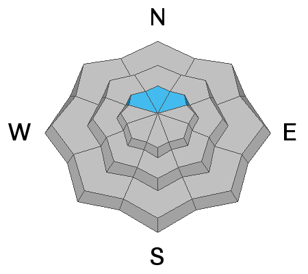
The avalanche danger starts out LOW this morning and may increase to MODERATE this afternoon as the snow gets wet from daytime heating.
The newer snow may become wet enough today to produce some minor wet snow avalanches.
Also, avoid steep slopes if you find yourself punching knee deep through wet sloppy snow later this afternoon.
Low
Moderate
Considerable
High
Extreme
Learn how to read the forecast here
Weather and Snow
Current Conditions
Riding conditions on Friday were pretty good with soft powder on the upper elevation northerly slopes. The snow didn't get as wet as I'd anticipated it would during the day and riding conditions should remain decent today. Temperatures on Friday reached 40˚F and cooled to around 30 overnight. That's a bit warmer than the previous night but with clear skies, everything should've frozen up decently. You'll find a melt/freeze crust on the surface this morning which should quickly soften as temperatures warm.
Mountain Weather
It'll be another nice day in the mountains with sun and temperatures into the mid to upper 40s. We'll have a few clouds move through this afternoon and westerly wind will pick up and feel a bit breezy along the ridges later on. The next storm is Monday night. It's not a huge storm but it looks like it might bring 3 to 6 inches of snow.
Ad
Avalanche Problem #1
Wet Snow
Type
Location
Likelihood
Size
Description
The more melt/freeze cycles we go through, the more stable things become. With another decent overnight freeze last night, the snowpack will be stable this morning. The typical springtime trick is to watch how the snow behaves during daytime heating. The two things you'll want to watch today are as follows:
  • There's about a foot of new snow from earlier in the week. This will get heated up during the day today to the point we could see some activity within that newer snow. East faces heat and become unstable first, then south, then west.
  • The second thing to watch for is areas where you start sinking deep into the snowpack later in the day. If you find yourself in areas where your boots punch through up to your knees or waist, it's time to avoid steep slopes and stay out of gullies and ravines with steep walls.
All that said, I'm not really anticipating any serious avalanche danger today.
Avalanche Problem #2
Persistent Weak Layer
Type
Location
Likelihood
Size
Description
There's something else interesting that I've noticed. Collapsing was experienced earlier this week by numerous people including myself. This was making me scratch my head a bit as I was trying to figure out which layer was collapsing. Yesterday I was able to get a slope to collapse with shooting cracks. I dug down through the foot of newer snow and determined that a thin layer of weak snow underneath last weekend's melt freeze crust was the culprit. I can't say I was expecting that. I covered a lot of terrain on Friday on my machine and only found one slope where this happened. I'm assuming this is an isolated problem but it's something to keep in mind. Furthermore, conditions change so rapidly during the spring that this problem will most likely not be a long lasting issue. Just keep in mind that you might be able to find an area where you could trigger a foot deep avalanche on those upper elevation more northerly facing slopes.
General Announcements
This forecast is from the U.S.D.A. Forest Service, which is solely responsible for its content. This forecast describes general avalanche conditions and local variations always occur.