Forecast for the Skyline Area Mountains

Brett Kobernik
Issued by Brett Kobernik for
Sunday, April 17, 2022
We have a generally LOW avalanche danger today.
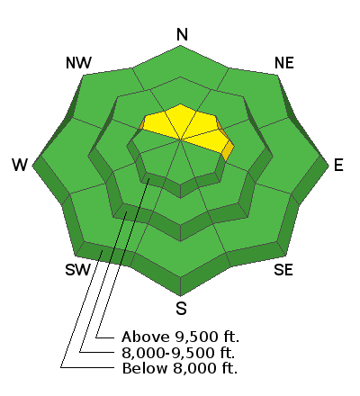
There may be some fresh drifts that a person could trigger near the ridgelines on north through east facing steep slopes.
We may see some minor wet activity involving the new snow later in the day as things heat up.
Low
Moderate
Considerable
High
Extreme
Learn how to read the forecast here
Special Announcements
Today is the last regularly scheduled avalanche forecast of the season. I'll do intermittent updates during significant storms through the end of the month.
Weather and Snow
Current Conditions
A quick hitting windy storm moved through late Saturday afternoon and dropped about 3 inches of new snow. Overnight temperatures hovered around 30˚F. The southwest wind was strong Saturday evening and has slowed down into the light to moderate speed range.
Mountain Weather
Skies should clear this morning and we'll have temperatures up into the mid to upper 40s. West wind will be light to moderate today increasing in speed a bit this afternoon. Monday and Tuesday look warm and clear then another minor storm will move through Tuesday night with the chance for minor snow accumulation.
Ad
Avalanche Problem #1
Wind Drifted Snow
Type
Location
Likelihood
Size
Description
The new snow combined with strong wind most likely formed some fresh drifts along and just below the ridges. These won't pose much threat of buring a person if you should trigger one. However, they may boss you around enough to knock you down. The most likely places to find trouble are high elevation northeast facing steep slopes just below the ridgelines. Also, watch these drifts as daytime heating occurs. There could be some cornices that break off during today's warm up.
General Announcements
This forecast is from the U.S.D.A. Forest Service, which is solely responsible for its content. This forecast describes general avalanche conditions and local variations always occur.