Forecast for the Skyline Area Mountains

Brett Kobernik
Issued by Brett Kobernik for
Wednesday, April 13, 2022
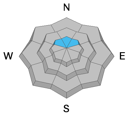
The overall avalanche danger is MODERATE today.
Watch for recent deposits of wind drifted snow. These may release if provoked by a person.
More dangerous conditions exist due to lingering concerns with a layer of loose sugary snow that formed mid winter.
There is still a chance that a person could trigger a large and deadly avalanche on northerly facing slopes steeper than 30˚ above about 10,000'.
Low
Moderate
Considerable
High
Extreme
Learn how to read the forecast here
Weather and Snow
Current Conditions
This has been a nice little winter-like storm with a good amount of snow and cold temperatures. Periods of snow on Tuesday added a few more inches bringing totals up to 9 to 12 inches. Temperatures stayed cool on Tuesday with cloud cover most of the day. This kept the snow conditions decent as it didn't heat up much and get wet. Overnight temperatures dropped back to around 10˚F. The southwest wind has been moderate over the last 24 hours. It's definitely drifted some snow.
Mountain Weather
Lingering light snowfall should come to an end this morning and we'll see mostly cloudy skies today with temperatures around 20˚F. West wind looks like it's going to increase mid day and could get fairly strong by late afternoon. It looks like clouds linger around in some capacity through Saturday with a gradual warming trend.
Ad
Avalanche Problem #1
Persistent Weak Layer
Type
Location
Likelihood
Size
Description
I have not been up into the higher terrain to look at detail on the condition of the old Persistent Weak Layer that formed in mid winter. By all that's right and holy, it should be gaining strength. However, it is a very unique layer which we have not seen the likes of before. That's enough for me to continue to use caution. Also, we've just added a foot of new snow which adds weight on top of the weak layer and stresses it. Very steep north facing slopes above 10,000' is where the concern still is.
Avalanche Problem #2
Wind Drifted Snow
Type
Location
Likelihood
Size
Description
I definitely noticed that fresh drifts were forming on Tuesday. I can't say that I really got a good handle on if any of these were sensitive and would perhaps crack out and release. I did not notice that the new drifts were particularly sensitive. However, I don't feel like I was in terrain that was all that great for making assessments. I didn't really find any steep slopes where a drift had formed that I could test. Use small test slopes and see if they will crack out when you ski or ride over them. Do this multiple times a day to get a feel if the new snow is sensitive and wants to crack out.
General Announcements
This forecast is from the U.S.D.A. Forest Service, which is solely responsible for its content. This forecast describes general avalanche conditions and local variations always occur.