Forecast for the Skyline Area Mountains

Brett Kobernik
Issued by Brett Kobernik for
Friday, March 17, 2023
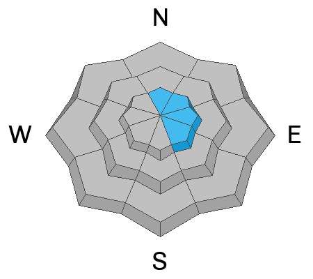
The overall avalanche danger is LOW on the Skyline today.
There is still a pockety MODERATE danger in the higher elevation north through east facing terrain where cornices and scattered wind drifts are present.
Human triggered avalanches are possible but not all that likely.
Low
Moderate
Considerable
High
Extreme
Learn how to read the forecast here
Special Announcements
HUNTINGTON CANYON SHOULD REOPEN LATER TODAY. UDOT ROAD CREWS ARE STILL DIGGING OUT AVALANCHE DEBRIS WITH HEAVY EQUIPMENT. THE ROAD REMAINS CLOSED FROM MILLER FLAT DOWN TO CRANDALL CANYON.
Photos: Jeremy Larson
Weather and Snow
Current Conditions: Temperatures on Thursday were in the mid 20s for the most part and really cooled off overnight with readings in the single digits. Wind has been calm to light in speed from the north. The sun heated many slopes and you'll find a crust on them this morning. Higher elevation more northerly facing terrain holds cold dense powder.

Mountain Weather: We'll have another day of sunshine and temperatures into the mid 20s. Wind will remain light from a northerly direction. Saturday looks similar with slightly warmer temperatures. We'll see clouds build in on Sunday ahead of the next storm system that will move through next week.
Recent Avalanches
As far as I know, there were no significant avalanches on Thursday. During fieldwork I was able to initiate a very small wet avalanche. It was actually what we refer to as a "push-alanche" because it is initiated when you push enough wet snow on the surface that it gains momentum and continues down the slope entraining more snow as it descends. This one only ran about 50 feet but did demonstrate that you could get longer running slides on steeper more sustained slopes.
Ad
Avalanche Problem #1
Normal Caution
Type
Location
Likelihood
Size
Description
The snowpack is becoming more stable.
I would continue to use caution on the higher north through southeast facing steep slopes along the ridges where LARGE cornices and some recent drifts are present.
Also, as always in the springtime, pay attention to daytime heating of the snow. If you find yourself in areas where the snow is really wet, punchy, and sloppy, you'll want to get off and out from underneath any steep slopes.
General Announcements
This forecast is from the U.S.D.A. Forest Service, which is solely responsible for its content. This forecast describes general avalanche conditions and local variations always occur.