Donate to Our Spring Campaign or Bid on our Spring Auction to Support Forecasting

Forecast for the Skyline Area Mountains

Brett Kobernik
Issued by Brett Kobernik on
Thursday morning, March 13, 2025
A storm starts to move in but it won't affect the avalanche danger much today.
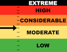
The avalanche danger is rated MODERATE today on the Manti Skyline.
The majority of the terrain has a mostly stable snowpack. There are still concerns about older weak layers of sugary facets. Areas with a shallower overall snowpack is where the weakest snow is and the most likely place to trigger an avalanche.
Low
Moderate
Considerable
High
Extreme
Learn how to read the forecast here
Special Announcements
Our Spring Campaign is in full swing, and there are two great ways to support forecasting, awareness, and education across Utah: Donate to our Spring Campaign Bid on items in our Spring Auction
Every dollar helps keep the backcountry community on top. Thank you for your support!
Weather and Snow
Current Conditions: It was another very spring-like day on Wednesday with sun, a few clouds moving in late and temperatures again into the 40s. Wind has been generally light from the southwest with a few puffs here and there.
Mountain Weather: We have a storm moving in that will produce some light snowfall today. Temperatures will get into the mid 30s. The rain/snow level will probably be up around 8000' before dropping to the valley floor Thursday night. The majority of the snow falls overnight and I'm thinking something like 5 to 9 inches should stack up by Friday morning. Weather remains unsettled Friday with a couple more impulses Friday night and Saturday. All said and done we should see totals around a foot of snow by late Saturday.
Ad
Avalanche Problem #1
Persistent Weak Layer
Type
Location
Likelihood
Size
Description
The new snow today won't pose much threat. I'm still concerned about deeper weak layers but this storm probably won't overload them and produce widespread avalanches.
The weakest sugary facets are in areas where the overall snowpack is shallow, like 4 feet deep or less. These are the most likely places that you might trigger something today if you are getting onto really steep terrain.
The likelihood of triggering something continues to decrease but any avalanche that breaks deep has to potential to be quite dangerous.
General Announcements
This forecast is from the U.S.D.A. Forest Service, which is solely responsible for its content. This forecast describes general avalanche conditions and local variations always occur.