Donate to Our Spring Campaign or Bid on our Spring Auction to Support Forecasting

Forecast for the Skyline Area Mountains

Brett Kobernik
Issued by Brett Kobernik on
Friday morning, March 14, 2025
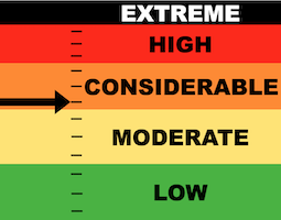
There's been just enough new snow and wind to bump the danger rating up to CONSIDERABLE today on the Manti Skyline.
Upper elevation terrain where the wind has blown the new snow and formed drifts and slabs is the most likely place to trigger something today.
The most likely situation is that avalanches will involve only the new snow but there's a slight chance that something may break deep into older loose faceted snow.
Low
Moderate
Considerable
High
Extreme
Learn how to read the forecast here
Special Announcements
Our Spring Campaign is in full swing, and there are two great ways to support forecasting, awareness, and education across Utah: Donate to our Spring Campaign Bid on items in our Spring Auction
Every dollar helps keep the backcountry community on top. Thank you for your support!
Weather and Snow
Current Conditions: We picked up 8 to 12" of new snow overnight. The central Skyline around the Horseshoes seems to have done the best. Wind has been a bit gusty from the northwest. Temperatures are in the teens. The new snow should be fairly low density. I'm guessing we're going to feel the bottom when we get out on skis and machines today.
Mountain Weather: Snowfall will taper off this morning and we'll have a break for most of the day. We may see the clouds part briefly. Wind from the northwest will slow into the light to moderate speed ranges. Temperatures will get into the low 20s. Another wave moves in tonight which could bring another 6 inches of snow through Saturday. Things clear out Sunday then another very windy looking storm will move through Tuesday that looks to bring another decent shot of snow.
Ad
Avalanche Problem #1
New Snow
Type
Location
Likelihood
Size
Description
New snow coupled with wind is always a red flag. I'm not sure how stable the new snow will be today so we must treat it as guilty until proven innocent. Here's how to handle this as you're getting into the mountains.
  • Look for fresh avalanches. If you see any, it's likely that more can happen.
  • Watch for cracking around your skis and machines. This is an indicator that the new snow is sensitive.
  • Use small steep test slopes (not large enough to cause harm!) to make cuts across them to try and get the new snow to move.
With the absence of these factors, the new snow is likely stable. Keep in mind that areas where the wind has drifted snow are areas where the new snow will be the most sensitive.
Avalanche Problem #2
Persistent Weak Layer
Type
Location
Likelihood
Size
Description
This is a tough one. Chances for triggering an avalanche that breaks into old sugary weak snow are getting fairly low. The new snow won't have increased the chances all that much but make no mistake, the weak snow is still down there. There was at least one avalanche triggered last weekend that broke deep into sugary loose snow. I think it's becoming unlikely but I wouldn't be surprised to hear about one this weekend.
General Announcements
This forecast is from the U.S.D.A. Forest Service, which is solely responsible for its content. This forecast describes general avalanche conditions and local variations always occur.