UDOT PLANNED AVALANCHE CLOSURES!!

Forecast for the Skyline Area Mountains

Brett Kobernik
Issued by Brett Kobernik for
Sunday, March 13, 2022
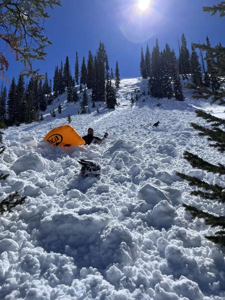
THE SNOWPACK REMAINS UNSTABLE AND DANGEROUS CONDITIONS EXIST!!
The avalanche danger is CONSIDERABLE on upper elevation northwest, north, northeast, and east facing slopes.
Deadly human triggered avalanches are likely.
If you avoid the terrain described above, the avalanche danger is much lower.
Low
Moderate
Considerable
High
Extreme
Learn how to read the forecast here
Special Avalanche Bulletin
The Utah Avalanche Center is issuing a SPECIAL AVALANCHE BULLETIN for Saturday, March 12, 2022. We are very worried that a serious avalanche accident could occur this weekend. A CONSIDERABLE avalanche danger exists across northern and central Utah -THIS IS WHEN WE SEE THE MOST ACCIDENTS AND FATALITIES.
DANGEROUS AVALANCHE CONDITIONS combined with great powder and beautiful weather make accidents likely. There have been many close calls this week, but luck eventually runs out. We commonly see a string of close calls leading up to serious accidents.
Two key messages:
  • Ensure everyone has and knows how to use an avalanche beacon, shovel, and probe.
  • Avoid being on, near or under all steep slopes and avalanche terrain. There is great riding and great powder on slopes less than 30 degrees in steepness where avalanches don’t occur.
Weather and Snow
Current Conditions
Saturday was a phenomenal day for skiing, snowboarding, sledding, snowshoeing, etc. Temperatures warmed into the upper 30s in many locations. There was lots of good settled powder but the sun took its toll on many slopes making them damp. You'll find widespread melt-freeze crusts today. Overnight temperatures were around 20˚F and wind is light to calm.
Mountain Weather
High temperatures will be around freezing today. We'll see the skies cloud up pretty quick ahead of a quick hitting small storm that might bring a few inches of snow tonight. Southerly wind will increase as the day goes on and will switch northwest during the storm. It looks like it could get pretty strong. Monday looks like a nice day with sun and mild temperatures. Tuesday will have some clouds ahead of the next storm system that should bring another small shot of snow Tuesday night.
Recent Avalanches
Wow. SO MANY avalanches were triggered on Saturday with numerous close calls. Here are just a few.
Rolfson Canyon. Snowmobile triggered from high on the slope:
Boulger Canyon near Electric Lake. Snowmobiler caught, carried, deployed airbag, partially buried, ended up ok:
Ad
Avalanche Problem #1
Persistent Weak Layer
Type
Location
Likelihood
Size
Description
There is no mystery to what is going on. The persistent weak layer of sugary snow from Jan/Feb continues to fail and cause avalanches. It remains dangerous again today. It is unclear when/if this layer will stabilize. This type of weak layer is very slow to gain strength, hence why we call it a Persistent Weak Layer. The bummer is that once it does stabilize, it is very possible it will become active again during our first significant spring warm up. Use caution. This is the type of conditions where people get killed.
General Announcements
This forecast is from the U.S.D.A. Forest Service, which is solely responsible for its content. This forecast describes general avalanche conditions and local variations always occur.