Forecast for the Skyline Area Mountains

Brett Kobernik
Issued by Brett Kobernik for
Sunday, February 3, 2019
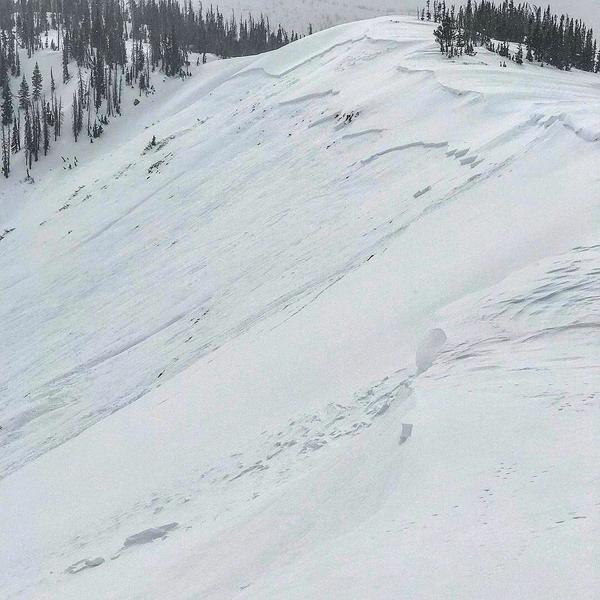
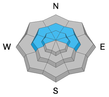
The overall avalanche danger is CONSIDERABLE today and human triggered avalanches are likely. You probably won't see many signs of danger out there aside from evidence of wind drifted snow. The current nature of the buried weak snow is to let you onto steep slopes which will release when you least expect it. You most likely won't experience any collapsing or shooting cracks. This makes for tricky assessment. North through east facing upper elevation slopes are the most dangerous.
ANTICIPATE AN INCREASING AVALANCHE DANGER THROUGH THE MIDDLE OF THE WEEK.
Low
Moderate
Considerable
High
Extreme
Learn how to read the forecast here
Weather and Snow
Temperatures were very mild on Saturday turning the snow damp on all aspects up to about 9000 feet. CHECK THIS BACKCOUNTRY OBSERVATION from John Pikus who was skiing up in Pleasant Creek.
We have a warm and windy storm in progress which dropped 3 inches of very dense snow overnight. The rain/snow level was around 8000 feet or higher. Temperatures are now cooling off and the rain/snow level has dropped down to the valley. We should see a few more inches of snow this morning before this portion of the storm moves out. We might some short periods of snow through Monday with continued moderate to strong southwest wind. The next system moves through Tuesday into Wednesday bringing perhaps 10 inches of snow or more if we're lucky.
Recent Avalanches
There was one significant avalanche reported that was most likely snowmobile triggered on Friday. It was in Seeley Canyon on an east northeast facing slope at 10,500 feet. It was at least 2 feet deep breaking into old snow. DETAILS HERE.
Ad
Avalanche Problem #1
Persistent Weak Layer
Type
Location
Likelihood
Size
Description
The most dangerous issue is avalanches breaking into old weak sugary snow. It should be obvious that if snowmobilers are still triggering avalanches just a few days ago, the addition of more snow is only going to make things more dangerous. Strong southwest wind is drifting snow and loading north and east facing slopes. You are not going to want to be doing any hill climbing or skiing steep lines for a while.
Avalanche Problem #2
Wet Snow
Type
Location
Likelihood
Size
Description
The snowpack in the lower elevations will most likely still be wet today. With cooling temperatures, any wet snow activity will be slowing down but I would still avoid being in any steep terrain where the snowpack is damp and saturated in the lower elevations.
Additional Information
This forecast is from the U.S. Forest Service, which is solely responsible for its content. This forecast describes general avalanche conditions and local variations always occur.