Forecast for the Skyline Area Mountains

Brett Kobernik
Issued by Brett Kobernik for
Saturday, February 2, 2019
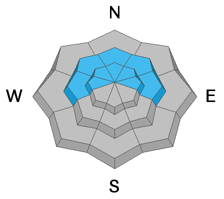
The overall avalanche danger is MODERATE today. Human triggered avalanches are possible. The most likely places to trigger an avalanche are on slopes steeper than 35 degrees on the east half of the compass and especially on slopes that have received wind drifted snow.
ANTICIPATE AN INCREASING AVALANCHE DANGER SUNDAY THROUGH THE MIDDLE OF NEXT WEEK.
Low
Moderate
Considerable
High
Extreme
Learn how to read the forecast here
Weather and Snow
The big news is the series of storms that will impact our area starting late today through the middle of next week.
The first portion of the storm is warm and windy. The rain/snow level will be up around 7500 feet. Wind will be strong from the southwest. I'm anticipating about 6 inches of dense snow into Sunday. Temperatures start to cool off on Sunday.
There will be a break in the storm Sunday afternoon into Monday. Periods of light snow are possible. More steady snowfall will return for Tuesday and we might see an additional 10 inches of snow by Wednesday morning.
Ad
Avalanche Problem #1
Persistent Weak Layer
Type
Location
Likelihood
Size
Description
The current snowpack is not the best and not the worst. That said, it has more weak snow than I prefer to see. This is no doubt a serious concern for the upcoming storm. There are numerous persistent weak layers of sugary snow within the snowpack which vary depending on locations, elevation and aspect. These weak layers have produced avalanches after the last three storms and I would anticipate seeing avalanches during and after this storm as well.
Additional Information
This forecast is from the U.S. Forest Service, which is solely responsible for its content. This forecast describes general avalanche conditions and local variations always occur.