Forecast for the Skyline Area Mountains

Brett Kobernik
Issued by Brett Kobernik on
Friday morning, February 27, 2026

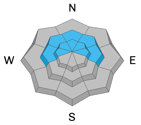
The overall avalanche danger on the Skyline remains CONSIDERABLE today.

Human-triggered avalanches are likely.

Wet natural avalanches are possible in the mid-elevations.

Continue to avoid being on OR BELOW steep slopes on the north half of the compass.

Low
Moderate
Considerable
High
Extreme
Learn how to read the forecast here
Weather and Snow

General Conditions: It is a mess out there right now. Unusually warm weather has moved in again. Temperatures were pushing 40°F Thursday and only cooled off to around freezing overnight. Wind from the west was breezy in the moderate speed range yesterday but has slow slowed at least in the mid elevations.

Mountain Weather: We will have mostly sunny skies with temperatures up around 40°F again today. Wind from the west will be light to moderate in speed. Warm temperatures persist through the weekend. We'll have some clouds on Saturday and more cloudy on Sunday with the slight chance of precipitation.
Avalanche Problem #1
Persistent Weak Layer
Type
Location
Likelihood
Size
Description

The old weak snow from December and January is still causing problems. Now, with the warm-up, there are two scenarios.

  1. Dry avalanches above 9500'. Well, mostly dry. The facets buried in the snowpack are still dry and slab avalanches can still be triggered like they have been over the last week.
  2. Wet avalanche below 9500'. The warm up and rain has saturated the snowpack below 9500' making it unstable. Point release avalanches are gouging into the old facets. Wet slab avalanches are possible.

Things are not as sensitive as they were before the warm up. That said, I don't trust the snow pack and I continue to avoid steep terrain.

General Announcements
This forecast is from the U.S.D.A. Forest Service, which is solely responsible for its content. This forecast describes general avalanche conditions and local variations always occur.