Forecast for the Skyline Area Mountains

Brett Kobernik
Issued by Brett Kobernik for
Thursday, February 22, 2024
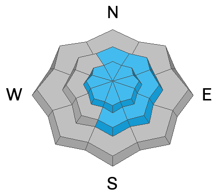
The avalanche danger rating for the Skyline is CONSIDERABLE today.
High density wind drifted snow has formed fresh drifts and slabs of snow that are likely to release today if provoked by humans.
Steep slopes just underneath ridgelines are the most likely places to trigger an avalanche today.
Low
Moderate
Considerable
High
Extreme
Learn how to read the forecast here
Weather and Snow
Current Conditions: Intense snowfall kicked in about 2pm on Wednesday quickly laying down up to 6 more inches of new snow. This brings totals up to 10 to 12" since Monday for areas north of Horseshoe Mountain. It looks like areas to the south of there picked up only about half that much. This last shot of snow was colder and lower density than the first half of the storm. The wind from the west was really blowing snow around on Wednesday but has dramatically slowed now and is almost calm now. Temperatures have cooled into the low 20s.
Mountain Weather: We have clouds still this morning and they may linger over the mountains for a good part of the day. Temperatures will get into the mid to upper 20s. Wind will be generally light from the northwest. We have a few mostly clear days coming up with gradually warming temperatures into Sunday. The next storm looks like it moves in Monday night.
Ad
Avalanche Problem #1
Wind Drifted Snow
Type
Location
Likelihood
Size
Description
The fresh wind drifts and slabs of snow that formed during the storm will likely still be sensitive today. You will want to step back a bit and avoid steep terrain where wind has drifted snow. Use small steep test slopes to try and crack out the new snow. This will help tell you how sensitive the new snow is. Layers from the last few storms are not completely stable so it's possible an avalanche could break deeper than just the new snow.
The snowpack should stabilize within a day or two but you'll want to reign it in a bit today.
General Announcements
This forecast is from the U.S.D.A. Forest Service, which is solely responsible for its content. This forecast describes general avalanche conditions and local variations always occur.