Forecast for the Skyline Area Mountains

Brett Kobernik
Issued by Brett Kobernik for
Sunday, February 17, 2019
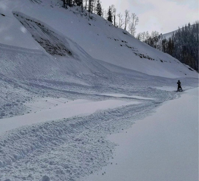
The avalanche danger is CONSIDERABLE today. Human triggered avalanches are likely on a variety of aspects and elevations. Treat any slope steeper than about 30 degrees as suspect. Areas which usually don't pose much threat are loaded up with snow right now and avalanches may occur in areas we don't expect.
Low
Moderate
Considerable
High
Extreme
Learn how to read the forecast here
Weather and Snow
A few more inches of snow trickled in on Saturday. The strong wind has let up and is light to moderate in speed from the west. Temperatures are cold with most stations in the single digits.
The weather will remain cold and unsettled for the next few days with periods of snow especially tonight through Monday. It doesn't look like it'll add up to much but perhaps we'll see another 4 to 6 inches of snow.
Recent Avalanches
There was one snowmobile triggered avalanche reported on Saturday. It was on the Ephraim Canyon road farther up the road from Bluebell Flats. What is notable is that it broke to the ground and it was a west facing slope in mid elevation terrain. This location generally has a shallow snowpack but it is now loaded up with quite a bit of snow. The point is that there are a lot of other areas out there that might be ripe for an avalanche in terrain we often don't think about being dangerous.
Photo: Brian Seeley
There was another large avalanche that was reported yesterday from the 12 Mile Canyon area. This one was a natural avalanche that released early Friday morning with the strong southwest wind.
Photo: Kreig Rassmussen
Ad
Avalanche Problem #1
Persistent Weak Layer
Type
Location
Likelihood
Size
Description
There were no big changes in conditions on Saturday. Avalanches breaking into deep buried weak layers remain my biggest concern. Be on guard at all elevations and aspects. The information below is from Saturday's forecast which describes what is happening in the higher terrain. The lower terrain has much weaker snow near the ground and any steep slope needs to be treated as avalanche terrain.
WE HAVE JUST RAPIDLY LOADED THE SNOWPACK AGAIN WHICH IS STRESSING IT! Obviously from the avalanche activity, the deeply buried persist weak layers of snow have been pushed to the brink. The term "weak" in the phrase "persistent weak layer" is relative. It's not that the buried weak snow is all that weak right now, it's that we've rapidly added a a very large load on top of it. When we have super weak layers of snow that get buried, they can't hold very much snow before they avalanche. The current buried persistent weak layers are not all that weak, thus, they can hold a lot of snow before they fail. My thinking is that after some more time to settle, the snowpack will become fairly stable and we may stop seeing avalanches breaking into these deep weak layers. FOR NOW, ANTICIPATE DANGEROUS AVALANCHE CONDITIONS THIS WEEKEND.
Additional Information
This forecast is from the U.S. Forest Service, which is solely responsible for its content. This forecast describes general avalanche conditions and local variations always occur.