Forecast for the Skyline Area Mountains

Brett Kobernik
Issued by Brett Kobernik for
Tuesday, February 12, 2019
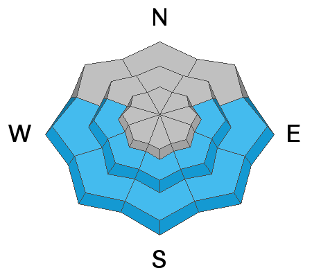
The majority of the terrain along the Skyline has a MODERATE avalanche danger. However, a CONSIDERABLE avalanche danger still exists in the upper elevation north through east facing slopes. These are areas that are holding old weak sugar snow deeper in the pack which is likely to collapse and cause an avalanche where the recent wind has drifted snow onto these slopes.
Low
Moderate
Considerable
High
Extreme
Learn how to read the forecast here
Weather and Snow
It looks like another nice day today with high temperatures in the mountains around 20 degrees. We'll see storms moving in late Wednesday night which could bring a substantial amount of snow.
Ad
Avalanche Problem #1
Persistent Weak Layer
Type
Location
Likelihood
Size
Description
The deeper buried persistent weak layers are adjusting to the new snow load from over the last week. They have gained strength and look good in some locations. However, I suspect in many areas the snowpack is unstable still. I am hopeful that our snowpack is starting to turn the corner to a more stable state. Hopefully this is more than just wishful thinking on my part. That said, I will need to see more widespread evidence of strengthening and less avalanche activity before I'm willing to get onto steep slopes.
Avalanche Problem #2
Wet Snow
Type
Location
Likelihood
Size
Description
The newest snow may be sensitive to the warming temperatures and direct sun on southerly slopes in the mid and lower elevations. Wet loose natural avalanches may release although my guess is this will be a fairly minor issue.
Additional Information
This forecast is from the U.S. Forest Service, which is solely responsible for its content. This forecast describes general avalanche conditions and local variations always occur.