Forecast for the Skyline Area Mountains

Brett Kobernik
Issued by Brett Kobernik for
Saturday, December 8, 2018
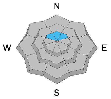
The majority of the terrain across the Skyline has a LOW to MODERATE avalanche danger. However, a CONSIDERABLE danger remains on steep slopes above 9500' that face northwest, north and northeast. The chances for triggering and avalanche are low but if you trigger one, it could be 2 to 4 feet deep and un-survivable.
Low
Moderate
Considerable
High
Extreme
Learn how to read the forecast here
Special Announcements
I'll be doing our annual avalanche presentation at Big Pine Sports on December 17th, 2018 at 7pm. It's free to attend and there will be food and drinks, good deals and some giveaways!
I'll discuss the start to our winter and current avalanche conditions. I'm thinking that I'll also review an accident or two that has occurred on the Skyline. There is always a lot to learn when reviewing accidents.
Weather and Snow
It was a quiet week for snow and weather. 2” of snow fell overnight. The good news is:
  • There have been no recent avalanches reported
  • Collapsing or "whoomping" of the snowpack has decreased
  • The wind has been well behaved and has not been blowing much snow around
  • The snowpack has gained strength and is stable along the majority of the Skyline.
The bad news is:
  • A poor snowpack structure with loose sugar snow near the ground is still present on northerly facing slopes above about 9500' (see video)
Ad
Avalanche Problem #1
Persistent Weak Layer
Type
Location
Likelihood
Size
Description
The snowpack has gained a lot of strength over the last 5 days. It is stubborn to collapse at this point. Triggering an avalanche is becoming more and more unlikely. However, things are tricky when we don't see obvious signs of danger. Make no mistake that the weak snow near the ground is still lurking in many spots. These are the type of conditions where it might be the 5th rider on a slope who finally triggers an avalanche.
Continue to dig down and look to see if there is loose sugar snow near the ground. If so, avoid steep slopes in those locations.
Additional Information
Weather Outlook:
High pressure moves in for the weekend bringing quite nice weather. We have cloud cover this morning but I'm expecting to see it breaks today, Sunday and Monday look more clear. Mountain temperatures will be in the mid to upper 20s. We’ll see light to moderate speed northwest wind today and lighter winds the next couple of days, A couple of small storms are shaping up for next week. I'll have more details in Sunday's forecast.
Be sure to check out all of the recent backcountry observations in the link below.