Forecast for the Skyline Area Mountains

Brett Kobernik
Issued by Brett Kobernik for
Tuesday, December 6, 2022
AVALANCHE CONDITIONS CONTINUE TO BECOME MORE DANGEROUS!!
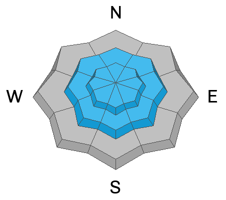
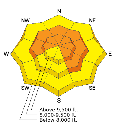
The avalanche danger remains CONSIDERABLE today. Human triggered avalanches are likely.
  • Each additional snow storm makes the avalanches larger
  • These avalanches can be triggered remotely (from a distance away) so it is important to watch for steep slopes above you
  • Continue to avoid being on or underneath slopes steeper than 30˚
  • Avalanche conditions are going to remain dangerous for some time to come
Low
Moderate
Considerable
High
Extreme
Learn how to read the forecast here
Special Announcements
FREE AVALANCHE AWARENESS PRESENTATION: Weds, Dec 7 at Tucker High Adventure Tours in Beaver, UT. MORE DETAILS HERE
Join the Utah Avalanche Center and the Division of Outdoor Recreation to celebrate the Fourth Annual Avalanche Awareness week, from December 4 - December 11. CLICK HERE to view the full list of events for the week.
Weather and Snow
Current Conditions: The Manti Skyline picked up about 6 inches of new snow in the last 24 hours. The southwest wind has really dropped off in speed and is a bit more from the west. Temperatures were again quite mild on Monday but dropped into the mid teens overnight. Riding conditions should be excellent.
Mountain Weather: Today we'll see light west southwest wind and high temperatures into the low 20s. The clouds may linger over the mountains through the day. More clouds move in on Wednesday with snow late Wednesday into Thursday. I'm thinking we should see 2 to 4 inches of new snow out of that system. The next storm system is shaping up for late Saturday into Monday. The weather pattern continues to look active over the next few weeks.
Ad
Avalanche Problem #1
Persistent Weak Layer
Type
Location
Likelihood
Size
Description
I cannot stress enough that the current avalanche situation is dangerous and will only get worse before getting better. A Persistent Weak Layer of sugary faceted snow that formed in November is now buried under about 2 feet of snow. The Persistent Weak Layer is collapsing and failing and causing avalanches, both human triggered and naturally releasing. Each storm buries the Persistent Weak Layer deeper making the avalanches larger. There is no mystery here. The pattern is clear. The most dangerous slopes face west, north, east and southeast. North and east facing slopes are even more dangerous because wind has been drifting snow onto those slopes.
General Announcements
This forecast is from the U.S.D.A. Forest Service, which is solely responsible for its content. This forecast describes general avalanche conditions and local variations always occur.