Forecast for the Skyline Area Mountains

Saturday morning, December 3, 2016
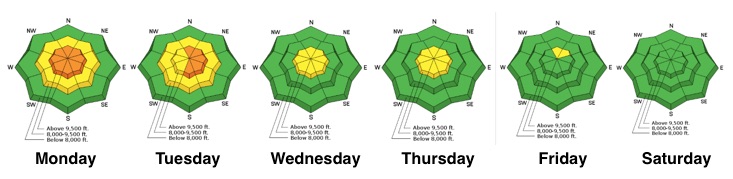
The majority of the terrain has a LOW avalanche danger. Watch for any drifting along the peaks if the wind does pick up this afternoon. Continue to practice safe travel by only putting one person on a steep slope at a time and clear the "avalanche run out zone" at the bottom.

Weather and Snow
The big storm earlier this week added 2 to 3 feet of snow which has settled to 20 to 30 inches in the 9000' range. It has consolidated nicely and travel is fairly easy. It is still quite shallow which limits travel quite a bit. In general, the snowpack currently looks really good and is mostly stable.
Here are some observations from during the week:
Region | Occurence Date | Type/Location | Name | |
---|---|---|---|---|
Skyline | 12/2/2016 | Observation: Electric Lake | Darce Trotter / Steve Cote | Details |
Skyline | 12/2/2016 | Observation: North Tent Mountain | Brett Kobernik | Details |
Skyline | 11/30/2016 | Observation: Skyline | Brett Kobernik | Details |
Temperatures are in the single digits this morning and the wind is generally light from the west. The snow surface consists of mostly dry powder with excellent riding conditions still.
Normal Caution


Description
There is really no significant weakness within the snowpack as of right now. It has become more stable during the week. Below is the danger rose trend since Monday:
You're main concern today would be if the wind increases enough this afternoon to drift snow along the higher peaks and ridges. This could form some fresh sensitive drifts. Because of the shallow snowpack, it is unlikely that many people will be in this type of terrain today.
Additional Information
It looks like we have a pretty nice weekend ahead with mostly clear skies and light to moderate west wind speeds. Temperatures today will get up to around 20 in the high country. Wind speeds might bump slightly this afternoon. Sunday looks fairly similar with temperatures getting into the upper 20s. There are a couple of small storms on the horizon for next week.
General Announcements
We will publish full detailed advisories Saturday and Sunday mornings by 7am. We will also be publishing basic avalanche danger ratings & info during the week.
If you are getting out into the mountains, we love to hear from you! You can SUBMIT OBSERVATIONS ONLINE or EMAIL US
If you would like to have avalanche advisories emailed to you, SIGN UP HERE
We can provide basic avalanche awareness presentations for your school, group or club. To enquire, CLICK HERE