Forecast for the Skyline Area Mountains

Brett Kobernik
Issued by Brett Kobernik on
Sunday morning, December 23, 2018
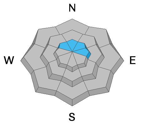
Due to a few periods of strong wind which blew a bunch of snow, a MODERATE avalanche danger still exists in the higher steep terrain that faces northwest, north, northeast and east. It's still possible a person could trigger a slab avalanche especially in the northwest, north and northeast facing terrain where there is loose sugary snow present near the ground.
Low
Moderate
Considerable
High
Extreme
Learn how to read the forecast here
Weather and Snow
No big change in conditions since Saturday. The ridgetop wind slowed and skies cleared mid day on Saturday. Overnight temperatures dipped into the single digits in the mountains.

Weather Outlook: We're in an active weather pattern through the week. It doesn't look like a huge amount of snow but hopefully we'll get a decent refresher. I'm thinking we'll see a few inches tonight night into Monday. The next storm is Christmas day which might bring 5 to 9 inches if we're lucky. This system is mainly diving off to our south so we'll see what we get left with. A few more inches may trickle in later in the week.
Ad
Avalanche Problem #1
Wind Drifted Snow
Type
Location
Likelihood
Size
Description
The recently formed drifts will be getting more stubborn to trigger today. That said, it's certainly still possible a person could trigger one. Continue to use caution in the upper elevation terrain where the recent wind has blown snow into deeper drifts.
Additional Information
This forecast is from the U.S. Forest Service, which is solely responsible for its content. This forecast describes general avalanche conditions and local variations always occur.