Forecast for the Skyline Area Mountains

Brett Kobernik
Issued by Brett Kobernik on
Saturday morning, December 22, 2018
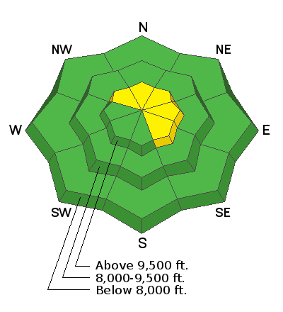
Increased winds Friday and overnight have created heightened avalanche conditions on any slope with wind drifted snow. You can trigger slabs of wind drifted snow on these slopes making the avalanche danger MODERATE at upper elevations. On steep slopes that face northwest, north and northeast that are holding wind drifted snow, there remains a chance of triggering an avalanche at the ground. To find good riding conditions and good stability, ride slopes not affected by the wind. Out of wind affected terrain the avalanche danger is mostly LOW.
Low
Moderate
Considerable
High
Extreme
Learn how to read the forecast here
Weather and Snow
Strong wind has been the biggest factor in affecting the avalanche conditions this week. The wind blew fairly strong on Wednesday and again on Friday. There was noticeable snow transport on both days. There was light snow showers on Friday adding a trace of snow. The wind definitely took this snow and blew it into fresh drifts.

Weather Outlook: We'll see partly cloudy skies this weekend with mountain daytime temperatures in the mid 20s and moderate speed westerly wind. The overall weather pattern is active with numerous storms moving through over the next week. The next one will be early Monday which could bring a few inches of snow. A bigger system will move through on Christmas which should bring a better chance for snow. There will be a few more chances for snow later in the week as well. All said and done, we'd be doing well if we picked up 8 to 12" of snow through the end of the week.
Recent Avalanches
During my travel on Friday, my partner and I stumbled onto a couple of recent natural avalanches. It's hard to determine when exactly they released but it appears they did since Wednesday. The most notable thing about these avalanches was that they both broke into weak sugary snow near the ground.
Ad
Avalanche Problem #1
Wind Drifted Snow
Type
Location
Likelihood
Size
Description
Westerly winds on Friday formed slabs of wind-drifted snow. Look for and avoid these fresh wind slabs under ridge lines and along cross loaded ridges. These slabs could be easy to trigger this morning but are an easy problem to avoid if you look for it.
Another reason to avoid these wind loaded areas is that they may have added just enough weight and stress to the snowpack to cause an avalanche to break on weak sugary snow near the ground. This is perhaps the most dangerous situation and most likely found on steep slopes above 9500' that face northwest, north and northeast.
Additional Information
This forecast is from the U.S. Forest Service, which is solely responsible for its content. This forecast describes general avalanche conditions and local variations always occur.