Forecast for the Skyline Area Mountains

Brett Kobernik
Issued by Brett Kobernik for
Saturday, December 15, 2018
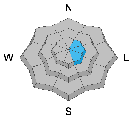
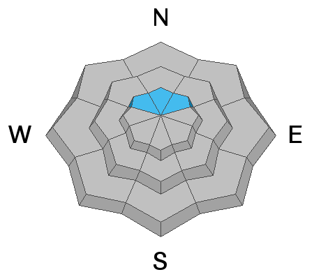
The avalanche danger is generally LOW in most locations. You can travel around and not worry for the most part. However, you can find trouble if you're looking for it. There is a MODERATE avalanche danger on steep slopes above about 9500 feet in elevation that face northerly through easterly. This means HUMAN TRIGGERED AVALANCHES ARE POSSIBLE. If you are going into upper elevation northerly through easterly facing terrain, keep your slope angles low to stay out of danger.
Low
Moderate
Considerable
High
Extreme
Learn how to read the forecast here
Special Announcements
Also, be sure to join us at Big Pine Sports in Fairview for a free avalanche presentation on Monday, Dec 17th at 7pm. There will be food, drinks, giveaways and great deals on gear.

Check out the new FREE ONLINE AVALANCHE COURSE series developed by the Utah Avalanche Center. This is a great way to refresh your skills or prepare you for a Backcountry 101 or Level 1 class.
Weather and Snow
The most significant weather and snow from the past week was a quick hitting windy storm on Wednesday. This gave us 4 to 5 inches of new snow but the snow also got blown around by the strong northwest wind. Some larger cornices formed, some of those breaking off during the storm. You'll find areas with large drifts as well as areas that are stripped of snow down to the dirt. Riding conditions are a mixed bag. They are not as good as before the windy storm but you'll still find areas with fun riding. The snowpack is quite supportable in most locations making travel easy. We have an average of 3' total snow depth in the upper elevation terrain. Keep in mind that it's still quite early in the season and you are likely to hit rocks and logs despite the decent start to the winter.
Recent Avalanches
I have not received any new reports of any avalanches. There was natural avalanche activity that happened on Wednesday during the last windy storm. Below are links to two avalanche reports from natural avalanches that I viewed on Thursday.
Wedding Ring Ridge
South Fork Lake Canyon
Ad
Avalanche Problem #1
Wind Drifted Snow
Type
Location
Likelihood
Size
Description
The most recent avalanche activity was a result of wind drifted snow on Wednesday. A large amount of snow was drifted onto the more east facing slopes. Today is the third day since these drifts formed so they will be a lot more stubborn to release at this point. I would continue to approach any large drifts or east facing high elevation slopes with caution though. There's still a chance that a person could trigger an avalanche in this terrain.
Avalanche Problem #2
Persistent Weak Layer
Type
Location
Likelihood
Size
Description
A persistent weak layer of old sugar snow near the ground remains somewhat of a concern on the steep upper elevation northwest through northeast facing slopes. The sugar snow near the ground is called a "persistent weak layer" for a reason. It can persist for a long time causing avalanches long after we might think it has stabilized. That said, I have noted that the weak sugar snow near the ground has gained strength over the last couple of weeks. It is becoming more unlikely to trigger an avalanche breaking into the sugar snow. However, if you do trigger something in this terrain, it's going to break to the ground and cause a deep avalanche.
Additional Information
Weather Outlook: This weekend will have quite nice weather with mostly clear skies, mild temperatures and generally light wind. Currently the long term forecast doesn't look good for snow for the next 9 days or so. There is a minor disturbance moving through on Monday cooling temperatures but it won't bring any snow. High pressure builds in behind this for the remainder of the week bring quite mild temperatures again. The next hint of a storm is looking like on about Christmas Eve.