Forecast for the Salt Lake Area Mountains

Nikki Champion
Issued by Nikki Champion on
Friday morning, January 2, 2026

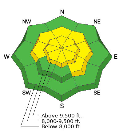
With heavy new snow and moderate winds, avalanche danger has risen to CONSIDERABLE on W-N-E facing slopes above 9,500 feet. Hard slab avalanches could be triggered, breaking 1–3+ feet deep and up to 100 feet wide on a persistent weak layer, particularly on steep, rocky slopes loaded by wind. On remaining upper elevation aspects and mid-elevation slopes facing W-N-E, danger is MODERATE.

Watch for blowing and drifting snow today. Avalanches initially triggered in wind-drifted snow could step down to deeper weak layers. Evaluate snow and terrain carefully, make conservative decisions, and avoid slopes steeper than 30 degrees with poor snow structure. Lower angled slopes offer safer options while still providing good riding.

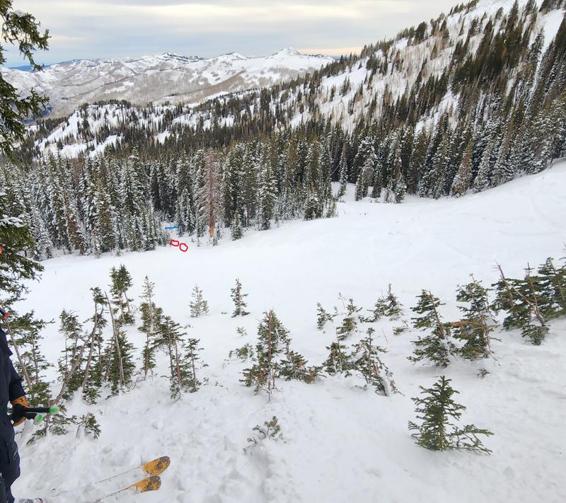
A slick rain crust is creating hazardous slide-for-life conditions. Exercise extra caution on steep, exposed terrain where self-arrest would be difficult.

Low
Moderate
Considerable
High
Extreme
Learn how to read the forecast here
Special Announcements

Happy New Year from all of us at the UAC. Thanks for another year of continued support.

On Wednesday, a backcountry skier slipped while skinning the ridge from Cardiff Pass toward Cardiff Peak. The slip led to an uncontrolled slide-for-life, and he slid to the north over the cliffbands into Cardiff Bowl. With the help of SL County SAR, WBR, DPS, Unified Fire, Life Flight, and Powderbird, the injured man was air-evac'd to the valley. While this accident was not avalanche-related, it is a significant event and a telling of the Christmas Eve rain crust's impact on conditions in the backcountry.

Weather and Snow

This morning, it continues to snow in the mountains, with an additional 3 to 8 inches of new snow overnight. The storm favored Upper Little Cottonwood Canyon, bringing storm totals to 3–13 inches of snow with 0.50–1.85 inches of water. Skies remain obscured, and the rain line is still hovering somewhere around 7500 to 8000 feet. Mountain temperatures are sitting in the upper 20s to the low 30s °F. Winds are blowing from the west at 10 to 20 mph, with gusts in the 30s along the highest peaks. Overnight gusts on the upper ridgelines reached close to 50 mph.

Today, the storm is expected to taper through the late morning into the early afternoon. Additional snowfall accumulation will be on the lighter side as conditions begin to dry out, with an expected 1 to 3 more inches of snow containing 0.1 to 0.3 inches of water. Winds will remain out of the west to northwest at 5 to 10 mph, with gusts in the 20s to 30s along upper elevation ridgelines.

Looking ahead, the weather stays active through the weekend and into early next week. While we may see some snowfall ahead of the next system, the bulk of the moisture arrives Sunday into Monday as an upper-level jet with Pacific Northwest-style moisture moves overhead. Some good news - the next storm looks cooler than the current one, with freezing levels expected closer to 6500 to 7000 feet. Current projections show 0.8 to 2.0 inches of water with 8 to 18 inches of snow.

The Week in Review is hot off the press. You can find it HERE.

Recent Avalanches

Yesterday, there were no new avalanche reports from the backcountry. Ski patrol teams reported a wet snow surface at the lower elevations of their mountains, allowing for easy push avalanches, or snow pushing on the supportable crust, along with one report of an explosive-triggered soft slab. Observations also noted sensitive wind-drifted snow at upper elevation ridgelines.

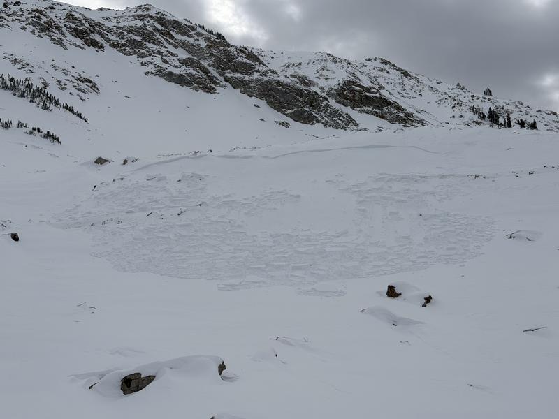
In partnership with Brighton Snow Safety, Brooke went out to investigate the report of the Hidden Canyon avalanche that occurred at some point earlier this week. While conditions did not allow them to access the crown, they were able to confirm through glassing that the avalanche failed on facets near or at the ground. You can find their full observation HERE. The slide occurred on a northwest facing slope around 10,350 feet. It appears to have failed up to 2 feet deep and 40 to 80 feet wide.

Avalanche Problem #1
Persistent Weak Layer
Type
Location
Likelihood
Size
Description

The Christmas Eve rain crust is creating a tricky, low probability but high consequence scenario, and crust thickness remains the most critical variable.

Our biggest concern is on slopes above 9500 feet, where less rain fell and the crust is thinner and less supportable. While we don’t have an exact pattern for where those thin crust areas exist, recent avalanche activity offers clues. It’s a good idea to build in a margin and avoid terrain similar to the Hidden Canyon and Sunset Peak avalanches: steep, rocky, and wind-exposed slopes. On most mid-elevation terrain, the crust is several inches thick, making triggering unlikely, but not impossible.

As we move into a more active pattern and add new load from snow, water, and wind, the likelihood of triggering this layer could increase again. Use this time to step back, watch how the interface responds, and re-evaluate terrain choices.

On December 30th, Dave Kelly visited the Sunset Peak avalanche. His observations are a bullseye for understanding this setup right now. The Sunset Peak bed surface is a sober reminder of what’s at stake, where a thin veil of snow masks the rock grinder you’d be dragged through.

Avalanche Problem #2
Wind Drifted Snow
Type
Location
Likelihood
Size
Description

The moderate westerly winds will continue to build shallow, soft slabs up to 2 feet thick near exposed ridges. These smooth, rounded pillows of wind drifted snow are forming on a variety of old snow surfaces. While initial wind-drifted avalanches will likely be shallow, there’s potential for them to step down into the deeper, more dangerous hard slab problem, 1 to 3 feet deep, on upper elevation W-N-E facing slopes.

Outside of the wind zone, sensitive new snow instabilities may exist on all aspects. Even a small loose or soft slab avalanche could run long and far on the supportable crust, especially in steep terrain where the snow surface is smooth and continuous.

General Announcements

This information does not apply to developed ski areas or highways where avalanche control is normally done. This forecast is from the U.S.D.A. Forest Service, which is solely responsible for its content. This forecast describes general avalanche conditions and local variations always occur.