UDOT PLANNED AVALANCHE CLOSURES!!

Forecast for the Salt Lake Area Mountains

Drew Hardesty
Issued by Drew Hardesty for
Tuesday, April 9, 2019
Another night without a good refreeze. Today, we'll have areas of Considerable avalanche danger for wet avalanches on many slopes. They will be most pronounced in the mid and low elevations and particularly on the north to east side of the compass. High northerly slopes will also be prone to wet sluffing in steeper terrain. Cornices and glide avalanche-prone slopes are to be avoided. Lastly, shallow new snow instabilities may spike with periods of heavy snowfall in the late afternoon.
Low
Moderate
Considerable
High
Extreme
Learn how to read the forecast here
Special Announcements
Grizzly Gulch will be closed TODAY as Alta conducts a joint rescue training with the American Avalanche Institute and USAF rescue personnel.

Our final podcast for the season has been released HERE. Low Danger - A Story in 5 Parts. Thanks much to our producer Benjamin Bombard and our sponsors Arva, Prival, and 2nd Tracks Sports.

Thanks so much to everyone who supported our spring fundraiser. We exceeded our goals. The UAC could not exist without your support.
Weather and Snow
Two long time meteorologists with a keen eye for mountain weather both described this upcoming storm as synoptically beautiful. Admittedly, they are both long time backcountry skiers, but when meteorologists gush and wax poetic about the structure of a storm, I sit up and take notice.
Skies are overcast with overnight "lows" in the upper 30s to mid-40s. Many stations remain at or near yesterday's highs. The winds backed to the south-southwest overnight and are blowing 15-20mph with gusts to 25. The most exposed anemometers are spinning 30-35mph with gusts to 50. It's our second night with a poor-if at all-refreeze and snow supportability will be spatially variable at best. In many areas, you'll sink up to your knees even with skis or snowshoes. Picture trenching on a sled. At least the initial precipitation today will fall as rain to 9500'. If there was ever a day to work on your taxes, this is that day. Probably best to stay on groomed, heavily packed, or low angle terrain, or rest up for some powder skiing and riding over the next few days.

But back to the synoptically beautiful storm. The NWS has issued a Winter Storm Warning with 1-2' of snow expected through Thursday. The sharp cold front arrives this afternoon (roughly 2pm) with a dramatic wind shift, gusty winds, and perhaps some thunder and lightning. I'd expect a fair bit of graupel. Snow will fall to the benches in the overnight hours. One of the meteorologists - Glen Merrill - went on to write that "Sensibly, it will be a good reminder that winter weather isn`t over yet, and spring in the eastern great basin is more like a roller coaster than a cruise."
Recent Avalanches
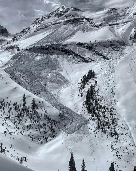
Longtime backcountry observer and UAC board member Peter Donner spotted a new large glide avalanche near the Diving Board area of Broads Fork (BCC). He estimated that it likely ran perhaps Sunday night into Monday.
Ad
Avalanche Problem #1
Wet Snow
Type
Location
Likelihood
Size
Description
With another night of sweltering temperatures and a warm blanket to help hold in the heat, wet sluff and wet slab avalanches are possible on many steep slopes today. Upper elevation northerly slopes are likely to sluff both with the temperatures and the initially high rain/snow line. Low and particularly mid elevation terrain (even more particularly northwest through north through southeast facing slopes) will also be avalanche prone, where human triggered sluffs will easily gouge into more wet unconsolidated grains a foot or more beneath the surface.
From a risk management perspective, today is classic High Risk Low Reward.
Avalanche Problem #2
Gliding Snow
Type
Location
Likelihood
Size
Description
Glide avalanches are difficult to forecast as they seem to happen at unpredictable times. What we know is that when we have a number of continuously warm days, lack of solid refreeze and smooth ground surfaces are prime conditions for these avalanches to occur. Before releasing, the snowpack typically produces large, visible cracks in the snow which tell us where these avalanches can occur. Overnight air temperatures are not a good indicator of the stability of this avalanche problem as glide avalanches can fail in the middle of the night when temperatures are at its coldest.
They often happen where the snowpack rests on top of rock slabs or smooth surfaces. Common places to find these cracks and glide avalanches are Broads Fork, Stairs Gulch, and Mill B South, and upper Raymond Slabs in upper Porter Fork. Knowing when they will occur is very difficult to forecast.
Photo of glide avalanche in Broads Fork (M. White).
Avalanche Problem #3
New Snow
Type
Location
Likelihood
Size
Description
If we see more snow than expected this afternoon, high snowfall rates will promote rapid instability with the new snow. I expect a good bond to the old snow surfaces, but high precipitation intensity generally leads to touchy conditions independent of aspect.
Additional Information
General Announcements
This information does not apply to developed ski areas or highways where avalanche control is normally done. This forecast is from the U.S.D.A. Forest Service, which is solely responsible for its content. This forecast describes general avalanche conditions and local variations always occur.