Forecast for the Salt Lake Area Mountains

Drew Hardesty
Issued by Drew Hardesty for
Thursday, April 7, 2022
The snow is generally stable and the avalanche danger is LOW.
Remember that risk is inherent in mountain travel and even a small avalanche can lead to a bad outcome in radical terrain. Watch for shallow pockets of wind slab in isolated terrain and expect shallow wet loose sluffing on the steep sunlit slopes with daytime warming.
Low
Moderate
Considerable
High
Extreme
Learn how to read the forecast here
Special Announcements
Snowbasin Ski Patrol is holding an avalanche dog fundraiser on Saturday, April 9th from 6-10pm at Mountain Luxury Real Estate, 3632 N Wolf Creek Drive in Eden, UT. The event costs $20 and includes dinner and a silent auction. Find more information HERE.
Weather and Snow
Skies are clear.
Mountain temperatures are in the low to mid-20s. Northwest winds are blowing 15mph with gusts to 20. Along the 11,000' level, winds are blowing 30-35mph with gusts to 50.
Fair and mild conditions are expected today and tomorrow ahead a series of increasingly cold and wet storms slated for this weekend and into next week.
Backcountry travel is easy and fun with a few inches of dense snow and some wind-effect capping myriad crusts. Southerly aspects will have a short lived crust this morning that will soften with daytime warming.

A sharp but dry cold front slices through Utah Saturday, dropping mountain temperatures to the low single digits by Sunday. This paves the way for an what looks to be a wet and stormy pattern for the week. Stay tuned.
Recent Avalanches
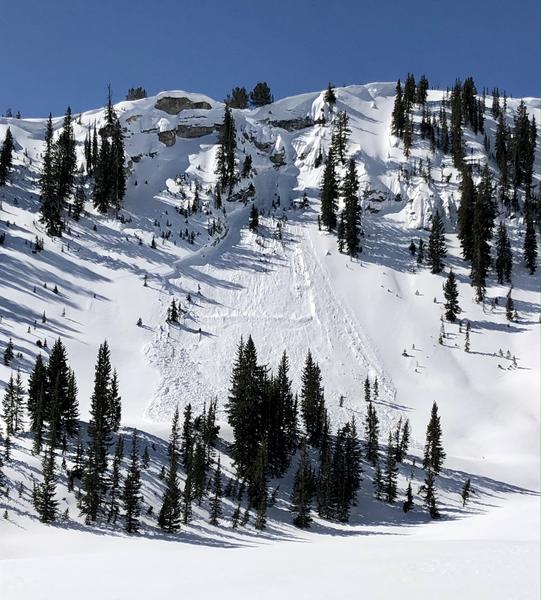
Observers noted what looked to be a natural cornice fall along the Silver Fork headwall that pried out a hard slab avalanche into old depth hoar below. This pocket is on a steep, rocky north facing slope at roughly 9800' and has avalanched at least twice already this season. (photo: Nic and Casey). No other avalanches were reported.

Find all observations HERE.
Ad
Avalanche Problem #1
Normal Caution
Type
Location
Likelihood
Size
Description
The snow is generally stable and the avalanche danger is LOW. If traveling into the mountains today, I would have a couple things on the radar:
  • Wet loose avalanches on the steep sunlit slopes. These wet sluffs will be shallow and slow moving but easy to trigger on the steeper sunny slopes today with daytime warming. Choose timing and terrain carefully.
  • Cornice fall and glide avalanches in the usual places of Stairs, Broads, Mill B South and Porter Fork are always possible this time of year.
  • Shallow pockets of wind slab exist in isolated terrain. These should not pose much of a problem except in or above radical terrain. Greg's snow profile and comments from yesterday are worth repeating: "Getting caught in a small avalanche involving a wind drift that fails in the graupel and runs on the slick crust as a bed surface where it would be difficult to self-arrest could be consequential in very steep, rocky terrain."
General Announcements
Who's up for some free avalanche training? Get a refresher, become better prepared for an upcoming avalanche class, or just boost your skills. Go to https://learn.kbyg.org/ and scroll down to Step 2 for a series of interactive online avalanche courses produced by the UAC.
This information does not apply to developed ski areas or highways where avalanche control is normally done. This forecast is from the U.S.D.A. Forest Service, which is solely responsible for its content. This forecast describes general avalanche conditions and local variations always occur.