Forecast for the Salt Lake Area Mountains

Greg Gagne
Issued by Greg Gagne for
Sunday, April 19, 2020
Today is the last regularly scheduled avalanche forecast for the season. We will issue updates with any measurable snowfall through the rest of April but will not issue danger ratings. Thank you to everyone for a great season.

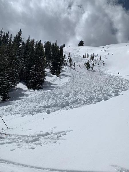
A MODERATE danger exists for triggering a soft slab avalanche 8-16" deep on northwest through east-facing aspects above about 9,000'. These avalanches may be triggered from a distance.

The danger for wet avalanches may rise to MODERATE on steep easterly to south to westerly facing aspects, as well as low-elevation northerly aspects. Avoid steep terrain when the snow is wet, punchy, and unconsolidated. Wet, concrete-like debris may pile up deeply in terrain traps and below steep, sustained terrain.
Low
Moderate
Considerable
High
Extreme
Learn how to read the forecast here
Special Announcements
The Avalanche Research Program at Simon Fraser University is conducting an online survey to examine how people use avalanche safety information. They want to hear from all backcountry users to understand how they process information provided in public avalanche forecasts. Anyone who completes the survey before May 15th will be entered to win cash prizes.
Weather and Snow
Currently: Temperatures are in the mid 20's F and winds are out of the west and are light, less than 10 mph, with gusts in the teens at 11,000'. Skies are partly-cloudy.

For today, increasing clouds with snow showers developing in the afternoon, including a chance of thunder. The rain/snow line will hover between 7,000 and 8,000'. Temperatures will rise into the 40's F and westerly winds should remain light, with gusts in the teens, and slightly higher speeds at 11,000'. It is possible isolated areas may pick up a trace to 2" of dense snow and graupel out of any snow shower activity today.
Recent Avalanches
After widespread avalanche activity on Thursday and Friday, with over 40 human-triggered avalanches reported to the UAC, the only avalanche reported from the backcountry on Saturday was on West Monitor Bowl along the Park City ridgeline. This was on a northeast aspect at 9,800' where a ski cut produced a soft slab avalanche 8" deep and 100' wide. It ran 400' vertical leaving a 5' debris pile. (Observation)
Ad
Avalanche Problem #1
New Snow
Type
Location
Likelihood
Size
Description
There remains an isolated chance of triggering a soft slab 8-16" thick resting on last week's thermal crust. The poor structure (strong snow over weak snow) is a mix of weak faceted grains above a hard crust, with a consolidating slab of storm snow on top. Yesterday's slide in West Monitor likely failed at this interface.
Collapsing and cracking may or may not be evident, and avalanches may be triggered from a distance. This problem exists on northwest through east aspects above about 9,000'. Additionally, isolated wind drifts may be found on these aspects at the highest elevations.
Avalanche Problem #2
Wet Snow
Type
Location
Likelihood
Size
Description
Wet avalanche activity today will depend upon cloud cover. Solar aspects are starting out solidly frozen this morning, but filtered sunshine may quickly warm the snowpack, with human-triggered and isolated natural wet snow avalanches possible. If clouds build up earlier than forecasted, these solar aspects may not soften that much. Additionally, greenhousing and possible rain may induce wet avalanche activity on low elevation northerly aspects.
Fortunately, managing the wet snow avalanche problem is pretty simple - if the snow starts becoming damp, move to a cooler aspect or lower-angled terrain.
Additional Information
Information on outdoor recreation - The State of Utah created this webpage with information about recreating on both state and federal public lands during the current health crisis.

Skiing and riding at closed ski resorts - Some resorts allow access now, and some do not. Please check HERE for the latest info on ski area access.

New to the backcountry (including riding at closed resorts) - Watch the award-winning, 15 minute Know Before You Go video, or take the 5-part, free online-learning series.
General Announcements
This information does not apply to developed ski areas or highways where avalanche control is normally done. This forecast is from the U.S.D.A. Forest Service, which is solely responsible for its content. This forecast describes general avalanche conditions and local variations always occur.