Forecast for the Salt Lake Area Mountains

Trent Meisenheimer
Issued by Trent Meisenheimer for
Saturday, April 16, 2022
A MODERATE avalanche danger exists at the mid and upper elevations. Human triggered avalanches 1-2' deep are possible, particularly in areas with recent drifts of wind-blown snow.

Cloud cover will be the WILD CARD. Any sun or green-housing today will make WET AVALANCHES the primary concern.
Low
Moderate
Considerable
High
Extreme
Learn how to read the forecast here
Special Announcements
The last regular forecast will be tomorrow, Sunday, April 17th. Intermittent forecasts will be issued through April based on weather conditions that affect avalanche danger.
Weather and Snow
Under partly to mostly cloudy skies, the mountain temperatures range from 28° to 34 °F. Winds have increased and are currently blowing from the southwest at speeds of 10-20 mph, gusting into the 30's.
Winds will continue to blow from the southwest and will increase throughout the day as another cold front approaches northern Utah this afternoon. Increasing clouds, thunder, wind, and snowfall will be the main story later this afternoon. We could see another 3-6 inches of new snow by tomorrow morning.
Unfortunately, the April sun came out strong yesterday afternoon, and many south and west aspects will be crusted this am. Last night, a good friend called me at 7:00 pm from Big Cottonwood Canyon and said even the upper elevation north-facing terrain took on some heat.
It's been a great return to winter, and this past week has had some impressive storm totals:
Upper Cottonwoods: 20-24" (1.38"-1.70" SWE) *snow-water-equivalent
Park City ridgeline: 12-24" (1-2.0" SWE): higher amounts along the northern end of the PC ridge
Ogden mountains: 20-26" (1.64" SWE)
Provo mountains: 6-10"(0.6" SWE)
Recent Avalanches
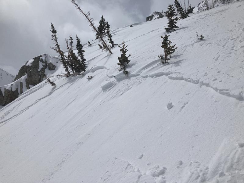
Couple of small wind slabs were reported yesterday, 4-6 inches deep, 30-50 feet wide (photo below: Harmsen). Different story in Logan with some avalanches 2 feet deep and over 1000' wide.
Ad
Avalanche Problem #1
Wind Drifted Snow
Type
Location
Likelihood
Size
Description
Over the past few days, active wind transport at the mid and upper elevations has been noted, and drifts may still be triggered in steep wind-loaded terrain today.
Overnight the southerly winds increased and are currently blowing at 10-20 mph, gusting into the 30's once again actively loading some slopes. These winds are forecast to increase today as a cold front arrives in northern Utah this afternoon. Be on the lookout and avoid both hard and soft drifts of wind-blown snow. Human triggered avalanches 1-2' deep are possible.
Avalanche Problem #2
Wet Snow
Type
Location
Likelihood
Size
Description
It seems clouds, wind, and a cooling trend should keep the wet snow at bay today. However, If the strong mid-April sun comes out for periods and/or is accompanied by intense green-housing, WET AVALANCHES may become the primary concern.
Direct sun will affect the solar aspects, while green housing will rapidly affect the cold snow on all aspects, even the mid-elevation northerly aspects. YOU'LL NEED TO BE YOUR OWN FORECASTER to see how the sky cover affects the snow surfaces. Roller balls are the first sign the snow is becoming unstable from heat.
General Announcements
Who's up for some free avalanche training? Get a refresher, become better prepared for an upcoming avalanche class, or just boost your skills. Go to https://learn.kbyg.org/ and scroll down to Step 2 for a series of interactive online avalanche courses produced by the UAC.
This information does not apply to developed ski areas or highways where avalanche control is normally done. This forecast is from the U.S.D.A. Forest Service, which is solely responsible for its content. This forecast describes general avalanche conditions and local variations always occur.