Join us at our 2nd Annual Blizzard Ball

Forecast for the Salt Lake Area Mountains

Mark Staples
Issued by Mark Staples on
Tuesday morning, April 14, 2020
Today avalanche conditions are generally safe and the avalanche danger is LOW. There are still ways to get hurt. In the upper Cottonwood Canyons, just enough snow fell with strong NW winds to create a few soft slabs of wind drifted snow that could be triggered. Also in these areas with new snow, today's strong sunshine could warm the few inches of new snow enough to cause shallow wet snow avalanches sliding on the hard ice crust underneath.
Low
Moderate
Considerable
High
Extreme
Learn how to read the forecast here
Special Announcements
The Avalanche Research Program at Simon Fraser University is conducting an online survey to examine how people use avalanche safety information. They want to hear from all backcountry users to understand how they process information provided in public avalanche forecasts. Anyone who completes the survey before May 15th will be entered to win cash prizes.
Chapter 7 of the Low Danger Series - The Crossing
Weather and Snow
Hello winter! This morning mountain temperatures are mostly in the single digits F. Northwest winds this morning are blowing 5-10 mph and gusting 15-20. Yesterday, northwest winds were blowing 15-30 mph with gusts at the highest elevations reaching 50 mph.
Yesterday morning in upper Little Cottonwoond Canyon, 3-6 inches of snow fell. Upper Big Cottonwood had 1-4 inches of new snow. Most other areas and lower parts of the canyons remained dry.
Today will have mostly sunny skies with maybe a few clouds in the afternoon. Temperatures should warm into the upper 20s F and winds should blow from the west-northwest at 5-15 mph at ridgetops. Snow should arrive tomorrow morning with 5-10 inches of snow possible by Friday.
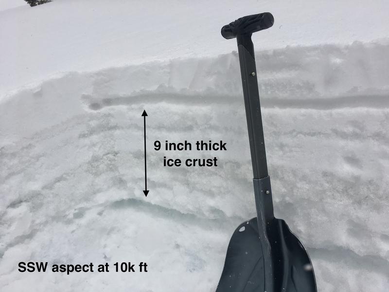
All slopes have a hard ice crust under yesterday's dusting of new snow. Yesterday in Grizzly Gulch, I found the ice crust on south aspects to be 9 inches thick (photo below). On north aspects, it was only 1 inch thick with a few thinner crusts under it.
Recent Avalanches
One skier triggered avalanche was reported yesterday on the shoulder of Mt Baldy in upper Little Cottonwood Canyon. It was a soft slab of wind drifted snow 3-6 inches deep and about 20 feet wide.
Ad
Avalanche Problem #1
Normal Caution
Type
Location
Likelihood
Size
Description
Avalanche conditions are generally safe but conditions today will vary between places that did or didn't receive snow yesterday.
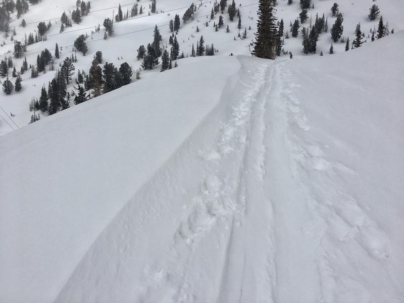
Wind slabs: Yesterday's strong NW winds drifted the few inches of new snow in the upper Cottonwoods. Nikki was in Big Cottonwood and I was in Little Cottonwood where we both found drifts up to 14 inches deep but small in area (photo below). These soft slabs only seemed to exist right at ridgetops and would be a concern only in isolated areas.
Wet snow: This afternoon on south and west aspects, shallow loose wet avalanches may occur when strong sunshine heats the few inches of new snow that is resting on a hard ice crust. In places without any new snow, warming and sunshine should just melt the thick ice crust enough to improve the riding conditions.
Slide-for-life: Hard icy conditions aren't an avalanche concern, but a hazard nonetheless in steep terrain where you wouldn't be able to stop if you fell.
Additional Information
Information on outdoor recreation - The State of Utah created this webpage with information about recreating on both state and federal public lands during the current health crisis.

Skiing and riding at closed ski resorts - Some resorts allow access now, and some do not. Please check HERE for the latest info on ski area access.

New to the backcountry (including riding at closed resorts) - Watch the award-winning, 15 minute Know Before You Go video, or take the 5-part, free online-learning series.
General Announcements
This information does not apply to developed ski areas or highways where avalanche control is normally done. This forecast is from the U.S.D.A. Forest Service, which is solely responsible for its content. This forecast describes general avalanche conditions and local variations always occur.