Donate to the 2024 Spring Campaign to help rebuild the UAC website.

Forecast for the Salt Lake Area Mountains

Dave Kelly
Issued by Dave Kelly for
Monday, April 10, 2023
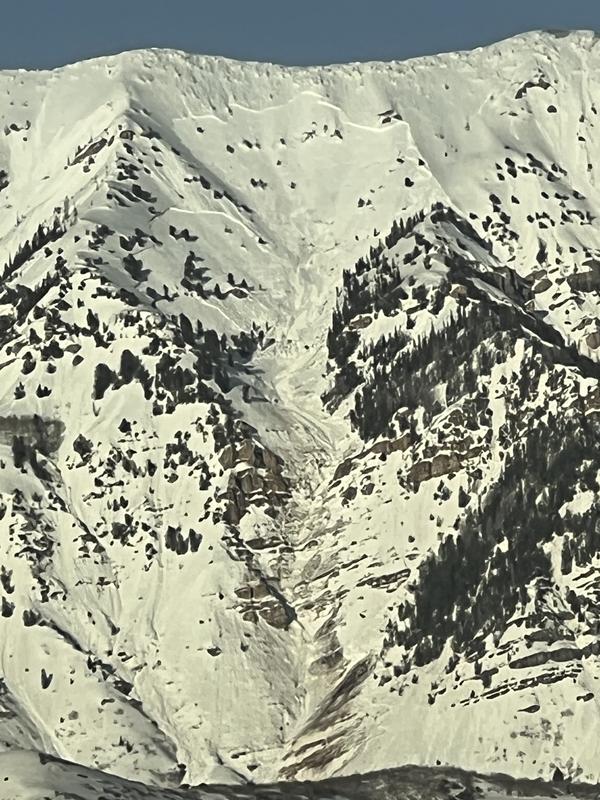
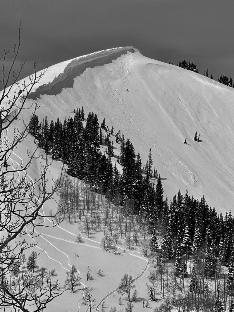
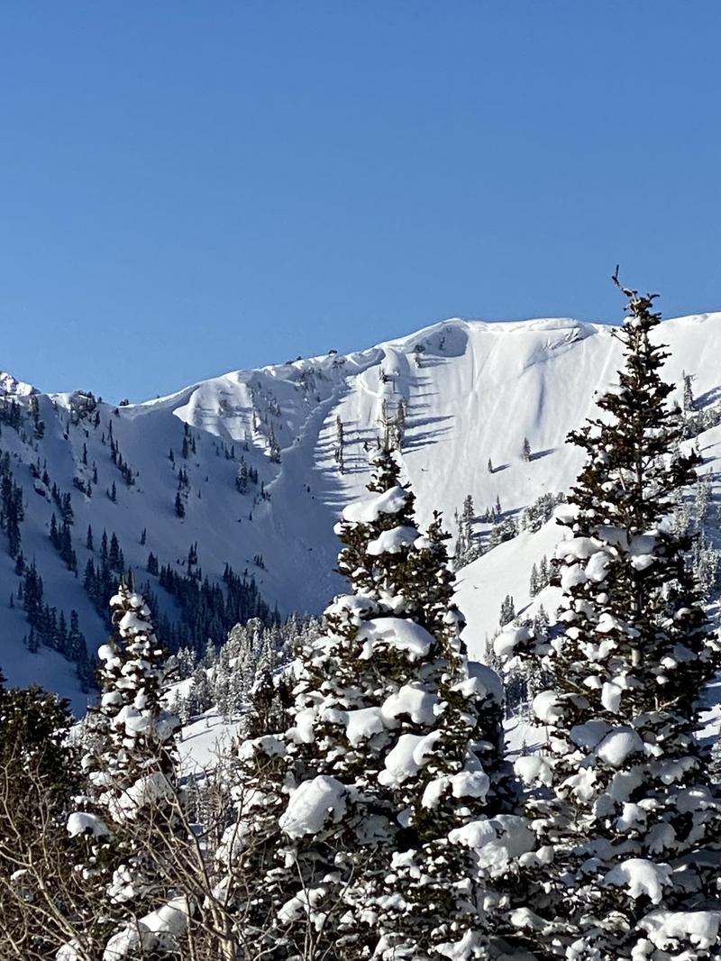
There will be a HIGH avalanche danger for wet avalanches. Avalanches will happen naturally today, and the debris can stack up very deep and run far especially in terrain traps like gullies.
You will find a CONSIDERABLE avalanche danger on upper elevation north facing slopes where there is a chance for large cornices to fail, or glide cracks to release and trigger a deeper longer running avalanche.
Plan ahead for early exits and avoid being on or under sun warmed slopes. These avalanches could be 2-5' deep and hundreds of feet wide. If you are sinking through the top 6-8" of the snowpack you're late, and it's time to exit the mountains and avoid any avalanche run-out zones.
Low
Moderate
Considerable
High
Extreme
Learn how to read the forecast here
Avalanche Warning
What: The avalanche danger for the warning area will very quickly rise to HIGH today with daytime heating.
Where: For the mountains and foothills of Northern Utah, including the Wasatch Range...Bear River Range...Wellsville Range...Oquirrh Mountains...Stansbury Range...Cache Valley...Ogden Valley
Impacts: Warm temperatures and the intense sun will create widespread areas of unstable wet snow. Natural and human-triggered cornice falls and wet avalanches are likely. People should avoid being in avalanche terrain (off of and out from under slopes steeper than 30°) and stay clear of avalanche run-outs on all aspects and elevations.
Special Announcements
The report for the Pole Canyon Accident is available HERE. Thank you to the people involved for sharing so much information so that we can all learn from this accident and come home safely to our loved ones.
Weather and Snow
This morning under clear skies. We have inverted temperatures with 11,000' ridgetops temperatures in the mid to high 30's ˚F and trailhead temperatures at or just above freezing ˚F. Winds are blowing lightly from the southeast. Freezing level will be at or above 10,500' by this afternoon.
For today, skies will be clear and sunny. Temperatures will be 54-58˚F, and winds will gradually increase from a south-southeast direction 15 gusting to 25 MPH at the 9,000' ridgelines and 15 gusting to 25 MPH at the 11,000' ridgelines.

Some mountain locations have not seen a re-freeze since Thursday April 7th. Clear skies last night have partially refrozen the surface snow, but as soon as the sun hits those areas it will turn mushy quickly. Rising temperatures mean that there is a limited time period for safe travel and as soon as you start to sink 6-8" into the snow surface it is time to get off of and out from underneath steep terrain.

Looking ahead, tomorrow will be warmer than today. A brief cold front is forecasted to come through with dropping temperatures and light snow Wednesday night into Thursday morning giving us a break from above freezing temperatures.
Recent Avalanches
Yesterday evening a natural avalanche cycle was reported in the Provo area mountains and there was a close call in Burch Creek on a west facing slope outside of Snowbasin's ski area boundary. The upper elevation terrain had a widespread wet-loose avalanche cycle during daytime heating with spectacular avalanches reported careening over cliff bands in Hellgate and on Cascade. Observers in Salt Lake reported being able to see wet-loose avalanches on west facing slopes from valley locations.

Photo of wet slab avalanche on Cascade Ridge (Mike B)
We continue to document and update avalanche observations from last week's historic avalanche cycle. Check out all avalanche observations HERE.
Ad
Avalanche Problem #1
Wet Snow
Type
Location
Likelihood
Size
Description
This morning you can expect to see a shallow re-freeze of the snow surface that will deteriorate quickly. As the day warms and the temperatures rise, the water will creep down into layers of the snowpack that are seeing free water for the first time this season, creating the potential for widespread destructive wet-slab avalanches as dry snow from last week's storm and old crust/facet combinations warm up and water percolates deeper through the snowpack.

Wet slab avalanches can be hard to time and avoidance is the best tactic. Wet slab avalanches can run further and longer than anticipated and the Snowbasin Ski Patrol reported that the skier triggered slide from Burch Creek ran down the drainage over a mile from the ridgetop.

We have an unprecedented amount of snow in the mountains which means that avalanches could run further and farther than anyone has seen.
Avalanche Problem #2
Cornice
Type
Location
Likelihood
Size
Description
Immense cornices have overtaken the most exposed ridgelines and are likely to become increasingly sensitive to warming temperatures. Cornice falls have two primary hazards:
1. Large and hard chunks of cornice debris could fall and crush you.
2. Cornice falls can trigger an avalanche onto the slope below, such as in Upper Days that occurred either Tuesday or Wednesday.
Avalanche Problem #3
Gliding Snow
Type
Location
Likelihood
Size
Description
Glide avalanches are a real threat this time of year, and many glide cracks are starting to open up more with each passing day. With continued warm temperatures and water greasing rocky bed surfaces these full-depth catastrophic avalanches could release triggering a wet slab avalanche as they take off down slope.

Because of how much snow we have had this season I would keep an eye out for glide avalanches in zones that don't normally see glide cracks. Avoidance is the key to this problem and I would avoid traveling in areas known for glide avalanches like Stairs Gulch, Broads Fork, Mill B, Mineral Fork, Mineral Slabs, Elk Point (Provo), Chili Peak Slabs (Ogden) and many others.

Yesterday Drew and I observed glide cracks on Dromedary and backcountry observers continue to report glide cracks opening up in new locations this season. Stay out from underneath slopes with glide cracks and you won't have issues with these types of avalanches.
General Announcements
This information does not apply to developed ski areas or highways where avalanche control is normally done. This forecast is from the U.S.D.A. Forest Service, which is solely responsible for its content. This forecast describes general avalanche conditions and local variations always occur.