Forecast for the Salt Lake Area Mountains

Mark Staples
Issued by Mark Staples for
Tuesday, March 31, 2020
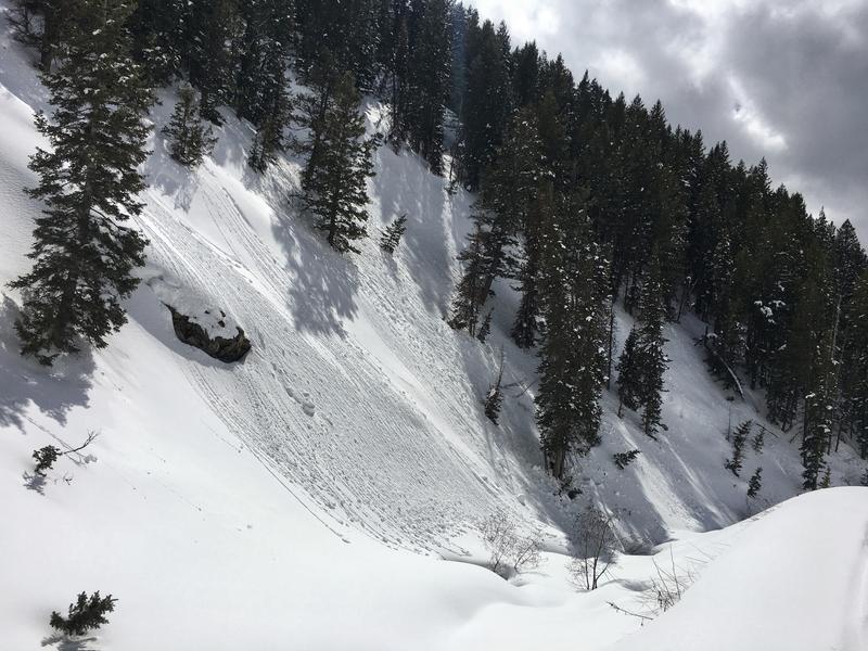
INCREASED WINDS have created dangerous avalanche conditions at upper elevations where the avalanche danger is CONSIDERABLE. Triggering a slab of wind drifted snow is likely. It remains possible to trigger a soft slab of new snow on slopes without wind drifting.

Triggering one of these slides remains possible at mid elevations where the danger is MODERATE.

The danger is LOW at low elevations where wet avalanches may occur depending on how wet the snow gets.
Low
Moderate
Considerable
High
Extreme
Learn how to read the forecast here
Special Announcements
If you rely on the UAC forecasts each day you get out, consider making a donation during our Spring Awareness Campaign to help us continue providing the avalanche forecasts and education you rely on.
The UAC encourages everyone to follow directions from state, city, and county officials. The following is from Joe Dougherty, spokesman for the Utah Division of Emergency Management:
Though outdoor recreation is still permitted under the governor’s Stay Safe/Stay Home directive, we recommend that people maintain a distance of at least 6 feet.
Be extra cautious to avoid injuries outdoors. We are working with our hospital systems to conserve as much personal protective equipment as possible in case of hospitalizations.
Most outdoor injuries can be prevented. Know the conditions and know your limits, so you don’t end up in a hospital.
Weather and Snow
Winds this morning have increased from the southwest. At ridgelines they are averaging 16-23 mph and gusting 33-47 mph. Even at lower elevations wind gusts are reaching 25 mph.
Temperatures this morning are about 8 degrees warmer than yesterday. They generally range from the mid 30s to mid 20s F depending on elevation.
Today will have mostly cloudy skies with some snow falling but only adding up to an inch of snow at best. Temperatures at lower elevations should warm into the mid 40s F. At upper elevations temperatures should warm into the upper 20s F. Winds will remain gusty today and will continue reaching speeds of 40-50 mph at upper elevations. There shouldn't be much sunshine getting through today's clouds but it's hard to say. Even a little sunshine can slip through thin clouds which can act as a greenhouse and make things feel quite warm.
The snow got warm and a little damp yesterday at low elevations and on higher slopes facing south and west.
Recent Avalanches
There have been a lot of avalanches recently but none reported yesterday other than a few very small wet point releases yesterday afternoon. All avalanche activity has occurred in snow that has fallen within the last week. Most have broken 1-2 feet deep. During this time 14 people have been caught and carried in these slides.
Check out all the recent slides HERE.
Ad
Avalanche Problem #1
Wind Drifted Snow
Type
Location
Likelihood
Size
Description
Fresh slabs of wind drifted snow will be the main problem to avoid today. The additional weight of wind drifted snow will make it easy to trigger slides in the new snow. These could be 3 feet deep and easily break over 100 feet wide OR MORE depending on the size of the slope.
Look for visual clues of slopes with fresh wind drifts and avoid them. Triggering a wind slab is possible at mid and upper elevations, but I think they will be most sensitive at upper elevations. Read more HERE on how to recognize this problem.
Avalanche Problem #2
New Snow
Type
Location
Likelihood
Size
Description
The problem is that the new snow hasn't stabilized at the same rate on all slopes. During the last five days there have been many avalanches; however, many people have found stable snow on many other slopes.
Last Tuesday the new snow began falling on a variety of snow surfaces and a variety of snow crystal types fell. In some cases as Drew found yesterday, the snow surface had weakened slightly. In other cases a layer of graupel formed a weak layer. And in other situations, there were simply layers of softer capped by layers of slightly denser snow that created avalanches. Now only a few slopes remain unstable.
What to do after you avoid wind loaded slopes?
(1) Roll the dice and take your chances which is a poor choice
(2) Dig in the snow, perform stability tests, check the snow on small test slopes, and evaluate stability on a slope-by-slope basis. This option is hard, takes experience, and you may still get it wrong.
(3) Given the current health care crisis, simply avoid avalanche terrain all together and ride slopes less than 30 degrees in steepness where avalanches don't happen.
Avalanche Problem #3
Wet Snow
Type
Location
Likelihood
Size
Description
With warmer air temperatures this morning and today, the snow at low elevations could get wet enough to create a few loose wet avalanches today. These are unlikely but worth watching for them. Watch out the snow reacts under you and watch for it getting increasingly wet by afternoon.
The photo below shows balls of snow rolling downhill yesterday afternoon. If those roller balls and pinwheels start gaining size as they roll downhill, it is a sign that wet avalanches are becoming possible.
Additional Information
Skiing and riding at closed ski resorts - Some resorts allow access now, and some do not. Please check HERE for the latest info on ski area access.
New to the backcountry (including riding at closed resorts) - Watch the award-winning, 15 minute Know Before You Go video, or take the 5-part, free online-learning series.
General Announcements
This information does not apply to developed ski areas or highways where avalanche control is normally done. This forecast is from the U.S.D.A. Forest Service, which is solely responsible for its content. This forecast describes general avalanche conditions and local variations always occur.