UDOT PLANNED AVALANCHE CLOSURES!!

Forecast for the Salt Lake Area Mountains

Nikki Champion
Issued by Nikki Champion for
Thursday, March 24, 2022
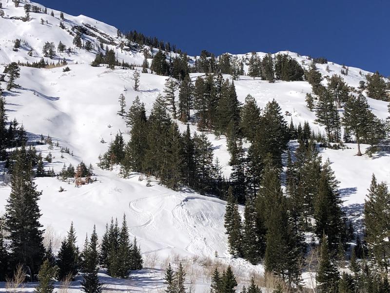
A MODERATE avalanche danger exists on steep west to north to east facing aspects at all elevations. Here, you can trigger avalanches 1-3' deep that fail on a persistent weak layer of faceted snow.
On all steep southerly facing terrain, and low elevation northerly terrain the avalanche danger will rise to MODERATE for wet-loose avalanches as strong sunshine and warm temperatures begin to heat the snow surface throughout the day.
Timing will be the name of the game over the next few days - once the snow surface becomes wet and unconsolidated it is time to move off of and out from underneath any steep slopes.
Low
Moderate
Considerable
High
Extreme
Learn how to read the forecast here
Special Announcements
Summary of Avalanches on the Jan/Feb Drought Layer PWL Feb 19-Mar 19: Some Surprises, Some Interesting Lessons.
Please help support avalanche forecasting throughout Utah. Donate to the Spring Campaign to help raise the funds to support the forecasting you rely on.
Weather and Snow
This morning, skies are mostly clear and mountain temperatures range in the upper 20s °F to mid-30s °F. Overnight temperatures hovered right below or at freezing at most elevations. Winds are currently from the northeast averaging 5-15 mph and blowing 20-30 mph across the upper elevation terrain.
Today, skies will become mostly sunny with mountain temperatures climbing into the upper 40s °F and low 50s °F. Winds will become west-northwesterly, and blow at speeds of 10-20 mph with gusts up to 40 mph at the highest ridgelines. Cold dry powder still exists in the mid to upper elevation northerly terrain. However, the powder compass will be shrinking more and more over the next few days.
Moving forward, warm air advection and high pressure (ridging) will dominate the weather pattern for the next week with plenty of sunshine and mountain temperatures skyrocketing. Many places across the Beehive State are slated for record-breaking temperatures.
Recent Avalanches
Yesterday, a local operation reported what appeared to be a recent skier-triggered avalanche on the lower benches of Highline in Mineral Fork failing 1-3' deep within the Jan/Feb facets. As well, a local ski resort reported some recent activity on the PWL. This avalanche occurred on a North aspect near 9600'.
Photo of the recent avalanche seen in Mineral Fork
Ad
Avalanche Problem #1
Persistent Weak Layer
Type
Location
Likelihood
Size
Description
Triggering avalanches 1-3' deep on steep slopes facing west through north and east at all elevations remains possible. These avalanches are failing on a persistent weak layer (PWL) that formed during the January/February drought.
Many of these avalanches are being triggered at the mid-elevations (8,000' - 9,500') and often in slight openings in otherwise dense trees. We've had many close calls throughout March on this weak layer and it's not time to let our guard down. Travel advice: Where the faceted snow is buried choose slopes less than 30° in steepness, with no overhead hazard.

A few things to remember when dealing with these persistent weak layers:
  • You won't know exactly when and where you will trigger the avalanche, but you will probably trigger it from a distance. These types of avalanches are unmanageable.
  • Tracks on the slope offer zero signs of stability. Avalanches can take out multiple existing tracks.
  • If you do choose to ride slopes where this layer exists, stack the odds in your favor by choosing slopes with a clean runout zone free of trees and rocks that would cause trauma if you do trigger an avalanche.
  • You may continue to find lingering pockets of sensitive wind-drifted snow at the upper elevations. Any fresh wind drifts could step down more deeply into the faceted January/February snow on the northern end of the compass. As always, look for and avoid slopes that look rounded and pillowy.
Avalanche Problem #2
Wet Snow
Type
Location
Likelihood
Size
Description
Overnight temperatures dropped just below or near freezing allowing the snow surface to mostly refreeze this morning. However, strong sunshine and warm temperatures could begin to produce wet, loose avalanches today once the snow surface begins to take on the heat. If you notice the snow surface becoming damp or unsupportable or see active roller balls cascading down, it's time to head home or change your aspect.
Fortunately, this is generally a predictable avalanche problem where you can expect avalanching in the wet snow once it begins to soften. The main concern is having a naturally triggered slide come down onto you, especially if you are in a gully, couloir, or other confined terrain where avalanche debris can pile up deeper and you have no route for escape.
Timing is key, once the snow surface becomes wet and unconsolidated it will be time to move off of and out from underneath any steep slopes.
General Announcements
Who's up for some free avalanche training? Get a refresher, become better prepared for an upcoming avalanche class, or just boost your skills. Go to https://learn.kbyg.org/ and scroll down to Step 2 for a series of interactive online avalanche courses produced by the UAC.
This information does not apply to developed ski areas or highways where avalanche control is normally done. This forecast is from the U.S.D.A. Forest Service, which is solely responsible for its content. This forecast describes general avalanche conditions and local variations always occur.