Forecast for the Salt Lake Area Mountains

Trent Meisenheimer
Issued by Trent Meisenheimer for
Tuesday, March 22, 2022
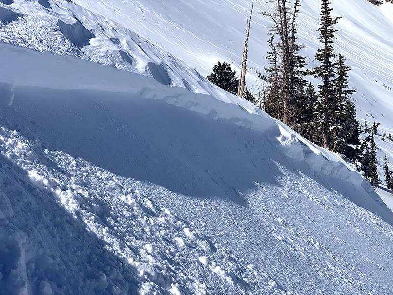
A MODERATE avalanche danger exists on steep west to north to east facing aspects at all elevations. Here, you can trigger avalanches 1-3' deep that fail on a persistent weak layer of faceted snow. You can trigger avalanches remotely, meaning from a distance or from below. These are not avalanches you want to mess with.
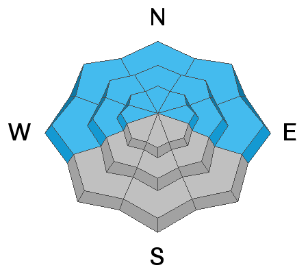
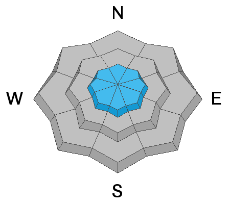
There is also a MODERATE avalanche danger on all aspects at the upper elevations where there are sensitive pockets of wind-drifted snow. On steep southerly facing terrain, the avalanche danger will rise to MODERATE for wet-loose avalanches as the strong March sun heats the snow.
Low
Moderate
Considerable
High
Extreme
Learn how to read the forecast here
Special Announcements
A new piece called " A Reckoning " talks about the recent string of human-triggered avalanches. (If you missed the essay Deus Ex Machina, published just at the onset of close calls and accidents, you'll find it HERE)

Please help support avalanche forecasting throughout Utah. Donate to the Spring Campaign to help raise the funds to support the forecasting you rely on.
Weather and Snow
Under clear skies, the overnight mountain temperatures dipped into the low to mid-teens °F. Winds have been from the northwest and blowing at speeds of 5-15 mph across the upper elevation terrain. At 11,000' the wind is blowing a bit stronger at speeds of 20-30 gusting 45 mph from the northwest.
Expect plenty of sunshine today with mountain temperatures rising into the mid to low 30's °F. Winds will remain from the northwest but slow in speed throughout the day. We warm up drastically later in the week.
Recent Avalanches
On sunny aspects, backcountry observers noted long-running wet loose avalanches that ran on top of old sun crusts. In some cases, these "sluffs" ran long distances. Across the upper elevations, many observers reported sensitive soft to hard drifts of wind-blown snow (wind slabs) that were roughly 12" deep by 30-70' wide (Nalli photo below).
Two or three people took rides in avalanches yesterday and luckily no one was injured. One on Pioneer Peak, another on Little Superior. There were about 20 observations from yesterday. Be sure to check them all out HERE.
Ad
Avalanche Problem #1
Persistent Weak Layer
Type
Location
Likelihood
Size
Description
Triggering avalanches 1-3' deep on steep slopes facing west through north and east at all elevations remains possible. These avalanches are failing on a persistent weak layer (PWL) that formed during the January/February drought.
Many of these avalanches are being triggered at the mid-elevations (8,000' - 9,500') and often in slight openings in otherwise dense trees. The snowpack is unlikely to give you the usual clues of collapsing or cracking and instead will fail on an unsuspecting rider when they are well down onto the slope, perhaps the 3rd, 5th, or 10th rider on the slope. We've had many close calls throughout March on this weak layer and it's not time to let our guard down.
My strategy is to avoid steep slopes steeper than 30° where there is faceted snow buried.
Avalanche Problem #2
Wind Drifted Snow
Type
Location
Likelihood
Size
Description
You may continue to find pockets of sensitive wind-drifted snow at the upper elevations. These fresh wind drifts may run long distances on slopes with smooth crusts underneath. Yesterday, many backcountry observers triggered wind slabs that were both soft and hard. These wind slabs were roughly 12" deep and up to 70' wide. As always, look for and avoid slopes that look rounded and pillowy.
Avalanche Problem #3
Wet Snow
Type
Location
Likelihood
Size
Description
Overnight temperatures dropped well below freezing allowing the snow surface to completely freeze this morning. However, today will be just a little warmer and by the afternoon I wouldn't be surprised to see and hear of some wet-loose avalanches happening on the steep sunlit terrain. Today is not the day to be ascending or descending steep south-facing terrain late in the afternoon. If you notice the snow surface becoming damp or unsupportable or see active roller balls cascading down, it's time to get out of there.
It's really hard to forecast wet snow. The temperatures don't skyrocket today and perhaps there is just a little wind to keep the snow surface cool. Or, the surface will heat rapidly and we will see wet avalanches. In any case, you need to be your own forecaster in the spring as weather conditions can change the avalanche danger quickly.
General Announcements
Who's up for some free avalanche training? Get a refresher, become better prepared for an upcoming avalanche class, or just boost your skills. Go to https://learn.kbyg.org/ and scroll down to Step 2 for a series of interactive online avalanche courses produced by the UAC.
This information does not apply to developed ski areas or highways where avalanche control is normally done. This forecast is from the U.S.D.A. Forest Service, which is solely responsible for its content. This forecast describes general avalanche conditions and local variations always occur.