Forecast for the Salt Lake Area Mountains

Greg Gagne
Issued by Greg Gagne for
Monday, March 21, 2022
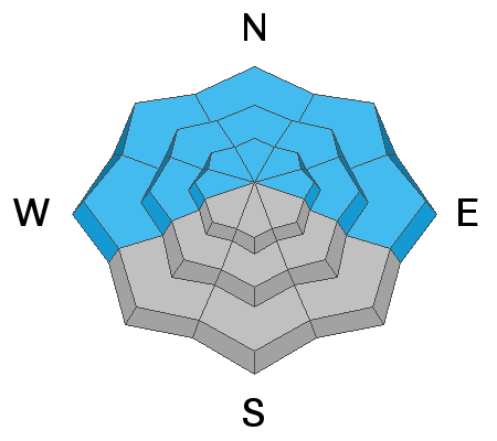
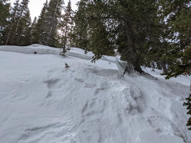
A 'scary' MODERATE danger exists on steep west to north to east facing aspects at all elevations. You can trigger avalanches 1-3' deep and you can trigger avalanches from a distance or from below. The danger is more pronounced on north to northeast-facing slopes at the mid-elevations.
There is also a MODERATE danger on all aspects at the upper elevations where there are pockets of wind-drifted snow.

Cool temperatures and northerly winds should keep the snow surface cool, but loose wet avalanches may be possible on steep southerly aspects.
Low
Moderate
Considerable
High
Extreme
Learn how to read the forecast here
Special Announcements
A new piece called " A Reckoning " talks about the recent string of human-triggered avalanches. (If you missed the essay Deus Ex Machina, published just at the onset of close calls and accidents, you'll find it HERE)

Please help support avalanche forecasting throughout Utah. Donate to the Spring Campaign to help raise the funds to support the forecasting you rely on.
Weather and Snow
Snowfall from Sunday is 3-8" with the highest amounts in upper Little Cottonwood Canyon.
This Morning: Temperatures are in the single digits and the northerly winds are light (less than 10 mph with gusts in the teens) but are much stronger at the upper-most elevations, averaging in the 20's with gusts in the 40's.
Today: Mostly sunny skies with temperatures rising into the 20's. Winds will be northerly, gusting into the 20's mph at mid elevations and near 40 mph at upper elevations.

Travel is easy with excellent coverage, particularly in the upper elevations. Base depths are 80-105" in the upper Cottonwoods and 50-80" along the Park City ridgeline. Sunday's dense storm snow should provide good riding conditions on sun-sheltered slopes at the mid and upper elevations.
Recent Avalanches
Thanks to all of those who have submitted reports and observations, particularly when avalanches occur: these help paint the most accurate picture of what's going on in the backcountry.

Avalanche activity on Sunday occurred midday during the period of heaviest snowfall with sensitive soft slabs and long-running sluffs.
Ad
Avalanche Problem #1
Persistent Weak Layer
Type
Location
Likelihood
Size
Description
Triggering avalanches 1-3' deep on steep slopes facing west through north and east at all elevations is possible, failing on a persistent weak layer (PWL) that formed during the January/February drought. These avalanches may be triggered remotely - from a distance or from below. Avalanches failing on this PWL continue to be reported, with the most recent reported avalanche occurrence from Saturday in Cardiff Fork on a northeast aspect at 9,000':
This has been an especially tricky avalanche problem and many people who have been caught, carried, and buried in these avalanches have significant backcountry experience. Many of these avalanches are being triggered at the mid elevations (8,000' - 9,500') and often in slight openings in otherwise dense trees. The snowpack is unlikely to give you the usual clues of collapsing or cracking and instead will fail on an unsuspecting rider when they are well down onto the slope, perhaps the 3rd, 5th, or 10th rider on the slope. The graphic below (from Drew Hardesty) highlights the reported avalanche activity on the PWL over the past month:
The only strategy for dealing with this tricky and dangerous avalanche problem is to avoid steep slopes facing west to north and east at all elevations.
Avalanche Problem #2
Wind Drifted Snow
Type
Location
Likelihood
Size
Description
Although any sensitivities from Sunday's storm snow should have settled out, you may find pockets of sensitive wind-drifted snow at the upper elevations. These fresh wind drifts may run long distances on slopes with smooth crusts underneath.
General Announcements
Who's up for some free avalanche training? Get a refresher, become better prepared for an upcoming avalanche class, or just boost your skills. Go to https://learn.kbyg.org/ and scroll down to Step 2 for a series of interactive online avalanche courses produced by the UAC.
This information does not apply to developed ski areas or highways where avalanche control is normally done. This forecast is from the U.S.D.A. Forest Service, which is solely responsible for its content. This forecast describes general avalanche conditions and local variations always occur.