Forecast for the Salt Lake Area Mountains

Trent Meisenheimer
Issued by Trent Meisenheimer for
Wednesday, March 16, 2022
Areas of CONSIDERABLE avalanche danger exist on steep aspects facing west to north to east at all elevations. Avalanches may be 2-4' deep, well over a hundred feet wide, and can be triggered remotely (from a distance).
A MODERATE danger exists across the upper elevations for shallow wind drifted snow avalanches. Look for and avoid wavey, rounded and pillowy snow.
Low
Moderate
Considerable
High
Extreme
Learn how to read the forecast here
Special Announcements
Drew Hardesty is a Blogging machine: A new piece called " A Reckoning " talks about the recent string of human-triggered avalanches.
The Accident report from March 12th in Silver Fork is now published. You can read the report HERE.
Weather and Snow
Under mostly cloudy skies, the mountain temperatures range from 20-30 °F. Winds are calm and blowing northwest at speeds of 5-10 mph across the upper elevations. Overnight the mountains picked up roughly 1-3 inches of new snow containing 0.06-0.18 inches of water.
Today, we will remain under a northwest flow with wind speeds possibly increasing to 10-20 mph across the upper elevation ridgelines. Mountain temperatures will climb into the upper 20's to low 30's °F this afternoon. Depending on your location, the occasional snow shower could produce some intense bursts of snowfall (rates of 1 inch/hr). Fingers crossed, we will squeak out another 1-3 inches of new snow throughout the day.
It's spring, and the weather can turn on a dime. Be sure to pay attention to changing conditions, i.e., sunshine hitting cold powder, green housing, or strong bands of snow (precipitation intensity). All of these weather events usually spike avalanche activity.
Recent Avalanches
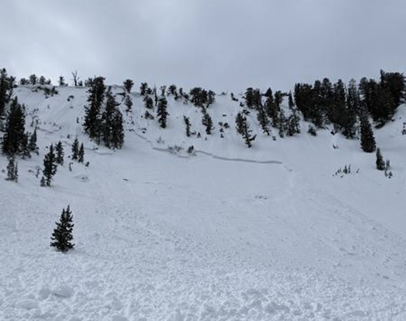
Yesterday, we had another two close calls. The first was in Millcreek Canyon, where a solo skier remotely triggered the upper headwall. The avalanche was roughly 2' deep 350' wide running 500 vertical feet downhill, stopping just 10' short of where he was standing (photo below).
The other was also a solo skier in Big Cottonwood Canyon, in an area known as Lucky Days. This avalanche was 2' deep 50' wide and caught and carried the skier. The skier hit a tree and had his skis and poles buried in the slide. Luckily in both accounts, everyone is okay.
Photo: Donner. Avalanche in Millcreek Canyon.
Ad
Avalanche Problem #1
Persistent Weak Layer
Type
Location
Likelihood
Size
Description
Many large and dangerous human-triggered avalanches have occurred over the past several days, failing on a layer of faceted snow (a persistent weak layer) that formed during the January/February drought. Avalanches failing on this weak layer are 2-4' deep and well over 100' wide and can easily catch, carry, bury, and kill a human.
My recommendation: is to avoid being on or below slopes steeper than 30 degrees on the north side of the compass for the time being. I have zero confidence in the snowpack right now. A few things to remember when dealing with persistent weak layers:
  • Persistent weak layers can be triggered remotely, from a distance, or from below. Look at the avalanche in Millcreek.
  • Avalanches can happen on short steep slopes in "what we think is benign terrain." Remember, avalanche terrain is anything over 30° in steepness. Read Lucky Days & Silver Fork.
  • This avalanche problem can produce very large avalanches that run long distances. Look at the slide in Mineral Fork.
  • Signs of instability may not always be present: you may or may not see or experience shooting cracks or audible collapsing.
  • Tracks on the slope offer zero signs of stability. Avalanches can take out multiple existing tracks.

Forecaster Confession: Yesterday, I was wrong. I wrote, " Avalanche professionals and people with years of experience are simply avoiding this type of terrain." By my count, we've had eight very close calls, and in fact, all of these close calls are by people that are either avalanche professionals or very experienced backcountry riders. This tells me that if the avalanche professionals are getting it wrong, we all need to take two steps back, and re-evaluate our decisions.
Avalanche Problem #2
Wind Drifted Snow
Type
Location
Likelihood
Size
Description
Ahead of yesterday's cold front, the southwesterly winds blew at speeds of 10-15 mph with gusts into the upper 20's and low 30's. As the front came through, the winds veered to the northwest and decreased in speeds.
A group of backcountry riders did trigger a wind slab avalanche yesterday that was 6" deep 10' wide in upper elevation steep north-facing terrain.
Be on the lookout and avoid snow that looks rounded, wavy, and pillowy. On southerly facing terrain, shallow soft wind slabs could run fast and far on the underlying crusts. On northerly facing terrain: any wind slab you may trigger has the potential to step down into our persistent weak layer, triggering a much larger avalanche.
General Announcements
Who's up for some free avalanche training? Get a refresher, become better prepared for an upcoming avalanche class, or just boost your skills. Go to https://learn.kbyg.org/ and scroll down to Step 2 for a series of interactive online avalanche courses produced by the UAC.
This information does not apply to developed ski areas or highways where avalanche control is normally done. This forecast is from the U.S.D.A. Forest Service, which is solely responsible for its content. This forecast describes general avalanche conditions and local variations always occur.