UDOT PLANNED AVALANCHE CLOSURES!!

Forecast for the Salt Lake Area Mountains

Nikki Champion
Issued by Nikki Champion on
Saturday morning, March 13, 2021
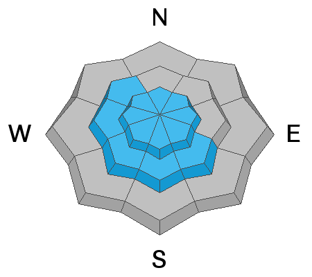
Most terrain has a generally LOW avalanche danger. However, areas of MODERATE danger exist at all upper elevations for triggering a fresh slab of wind drifted snow. These wind slabs will be generally shallow and isolated to terrain features that allow for drifting snow to accumulate. In wind-sheltered zones, the new snow will likely lead to shallow soft slab avalanches or minor sluffing on the steepest slopes today.
Falling in steep terrain and being unable to stop on hard, refrozen snow underneath the new snow remains a hazard.
Low
Moderate
Considerable
High
Extreme
Learn how to read the forecast here
Weather and Snow
This morning, skies are overcast and it is lightly snowing. Mountain temperatures are in the mid-teens to low 20s F. Another 3-8" of snow fell overnight. The overnight winds have increased and transitioned from East to East Northeast. Currently, the winds are averaging 5-15 mph, with gusts above 30 mph at upper elevations.
Today, another 2-4 inches of snow could fall. Winds will continue to increase into the evening and temperatures should warm into the mid-20s F and low 30s F. The wind speeds will average 15-25 mph, with gusts up to 40 mph at upper elevations.
Total snow amounts have reached somewhere between 10-24" since Wednesday, favoring the Park City Ridgeline. Following the initial new snow on Wednesday, the sun came out and made the new snow damp on the east, south, and west aspects causing those aspects to refreeze into a firm riding surface. Overall, riding conditions have improved greatly. On the solar aspects, you can feel the firm surface from Wednesday beneath the new snow, in more protected areas you will find the best riding.
Our Week in Review - where we highlight significant avalanche and weather events from the past week has been published.
Recent Avalanches
Yesterday there were a few small, loose avalanches in the new snow as well as some small sensitive wind drifts at mid and upper elevations reported in the morning. Midday, the snow surface became wet within Little Cottonwood Canyon and some wet loose avalanches were reported. One on the Emma's broke 35' wide and ran 400'.
Photo from the Emma's - wet loose avalanche midday yesterday. Photo: A. Robinson

Read what people are finding under Observations and Avalanches.
Ad
Avalanche Problem #1
Wind Drifted Snow
Type
Location
Likelihood
Size
Description
Yesterday, just a small bump in the east winds causes us to see sensitive slabs of wind drifted snow in mid and upper elevation terrain features such as ridgelines and gullies. Since yesterday, the winds have only continued to increase and will continue increasing throughout the day. The new snow combined with increasing winds should create some soft slabs of wind drifted snow at upper elevations, and mid-elevation terrain features such as sub-ridges and gullies. These wind slabs will be shallow and overall small in size, but these new wind drifts are sitting atop of a firm snow surface which will make them very sensitive and cause them to run far and fast. Even a small avalanche would be enough to knock a person off their feet and through complex terrain.
Look for any slopes with signs of wind drifted snow, and avoid those slopes. Wind-affected snow often looks wavy, rounded, pillowy, and can sound hollow when walking or riding on it.
Avalanche Problem #2
New Snow
Type
Location
Likelihood
Size
Description
Since Wednesday, anywhere between 10-24 inches of light snow has fallen on an array of firm snow surfaces in the backcountry. In area's sheltered from the east winds, I would expect to continue seeing shallow new snow avalanches today. The primary concern will be fast running sluffs in steep terrain, these may run naturally if there are any periods of heavy snowfall this afternoon. Any area that still held any lingering soft snow for multiple days will be suspect for some shallow soft slabs to form. Remember that even a small avalanche can be problematic in very steep and complicated terrain. Think about the terrain you are traveling above today.

If the sun comes out for any reason today, that new snow will immediately become wet and wet avalanches will begin occurring. Pay attention to changes in conditions if you see roller balls and pinwheels - or the snow surface feels damp, it may be time to change your plans.
Additional Information
So what about that weak faceted snow on the ground? Mark and Trent talk about the snow they saw yesterday in Snake Creek.
General Announcements
Please visit this website with information about Responsible Winter Recreation by the Utah Office of Outdoor Recreation.

This information does not apply to developed ski areas or highways where avalanche control is normally done. This forecast is from the U.S.D.A. Forest Service, which is solely responsible for its content. This forecast describes general avalanche conditions and local variations always occur.