11 AM UPDATE - UDOT HAS CLOSED LCC NORTH SIDE SUPERIOR THROUGH CARDIFF PASS FROM 10:30 AM TIL 6 PM FOR AVALANCHE CONTROL WORK. (MAP) PLEASE STAY EAST OF CARDIFF BOWL.
Chapter 5 in the LOW Danger series has been published. It's the first of two first-hand accounts of the Blue Ice avalanche from January 5th. One can find all the chapters in the Blog page in the menu above.
Chapter 6 in the LOW Danger series is now published. It's the second of two first hand accounts of the Blue Ice avalanche from January 5th.
Thanks to these two. These stories need to be told.
Enjoy spring skiing at Snowbasin Resort. The UAC has discount Snowbasin tickets available.
INFO
A strong cold front entered the Wasatch mountains overnight with snowfall beginning just after midnight. As of 7 am snow totals are 4-8”, with the highest amounts in upper Little Cottonwood. Winds are out of the northwest and gusty. At the mid elevations winds are averaging less than 10 mph, with gusts in the teens. At upper elevations wind are averaging in the teens with gusts in the 20’s. Gusts are in the 30’s at 11,000’. Mountain temperatures range through the teens F.
For today, expect periods of moderate to heavy snowfall, with storm totals of 8-16" by late afternoon; highest amounts in upper Little Cottonwood which fares very well with a northwest flow. Temperatures will be in the teens at mid and upper elevations, and low to mid 20's F at lower elevations. Winds will be out of the northwest. At the mid elevations winds will average in the teens, with gusts in the 20’s mph. At upper elevations add about 10 mph to those numbers, averaging in the teens and low 20’s mph, with gusts in the 30’s mph.
Continued snowfall is expected overnight, with an additional 3-6" possible. Highest amounts in upper Little Cottonwood. Clearing during the day on Thursday, with cool temperatures in the teens and 20's mph.
For the extended forecast, Friday looks to remain cool, but a strong ridge of high pressure moves in and stays put for awhile. 10,000' temperatures will be above freezing by Sunday.
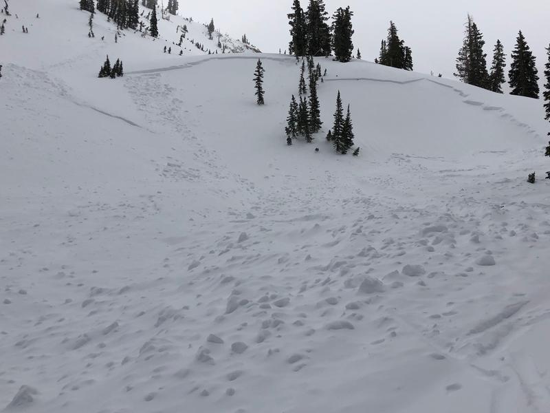
Cloud cover and southwest winds kept wet activity to a minimum on Tuesday, with only minor wet loose activity reported.