Forecast for the Salt Lake Area Mountains

Nikki Champion
Issued by Nikki Champion for
Monday, February 8, 2021
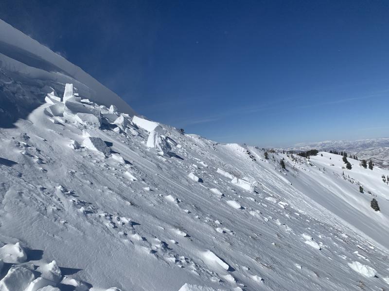
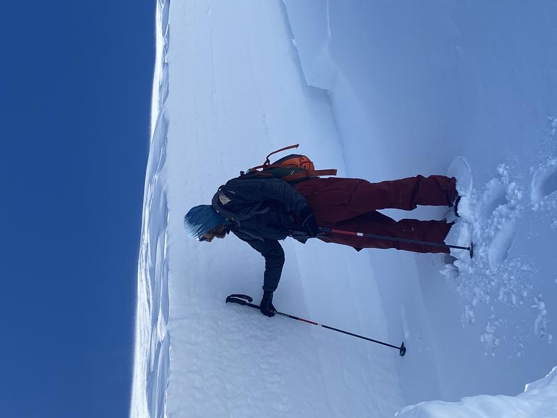
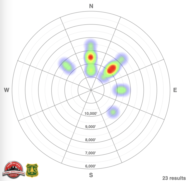
The avalanche danger is CONSIDERABLE on all upper elevation aspects and mid-elevation aspects facing west, through north, through southeast. This past week's new snow and recent strong winds have overloaded the snowpack on many slopes at the mid and upper elevations. Dangerous avalanche conditions exist. Any natural or human-triggered avalanche can be up to 5' deep, several-hundred feet wide, and likely unsurvivable.
The remaining aspects have a MODERATE avalanche danger.

Choosing low angle terrain with no overhead hazard is critical today.
Remember: If you're leaving a resort boundary through an exit point, you are stepping into CONSIDERABLE avalanche danger.
Low
Moderate
Considerable
High
Extreme
Learn how to read the forecast here
Special Announcements
We are filled with grief to report four avalanche fatalities Saturday in the Wilson Glade of upper Mill Creek Canyon. The avalanche involved two separate parties. Our deepest condolences go out to the friends and families involved. Our deepest gratitude goes out to Wasatch Backcountry Rescue, Intermountain Lifeflight, the Department of Public Safety, the United States Forest Service, and Brighton, Solitude and Alta Ski Patrols for providing resources and support during this tragic accident.
We investigated the accident yesterday, our preliminary report will be continually updated over the next several days as we work on the final report.

This avalanche brings us to six avalanche fatalities in Utah for the 2020/2021 winter.
Since February 1, there have been fourteen avalanche fatalities in the US. Yesterday's four fatalities marks the largest avalanche accident in Utah since the February 1992 tragedy that killed four in the La Sal mountain range east of Moab.
Weather and Snow
This morning, under partly cloudy skies mountain temperatures are in the mid 20s F. Westerly winds remain gusty, but have decreased since yesterday, averaging 15-20 mph with gusts to 30 mph. The highest elevation winds are gusting into the 50s mph.
Today will bring increasing cloud cover throughout the day, ahead of the next weak storm system moving in this evening. The westerly winds will remain moderate, with gusts up to 30 mph at mid-elevations and up to 60 mph at the highest elevations. Temperatures will rise into the mid-30s F.
Looking ahead: The next system will be beginning late Monday night into Tuesday evening and bring light to moderate snowfall accumulation, between 2-6" of snow. A more active pattern, with moderate to heavy snowfall totals, should move into the area late Thursday through Sunday.
Recent Avalanches
Multiple new avalanches were reported in the backcountry yesterday. All of the avalanches reported yesterday occurred naturally sometime during the evening between the 6th and 7th, or early on the morning of the 7th. Most of the avalanches were 2-3' deep and serval hundred feet wide. Most of these avalanches ran on steep northwest to east-facing slopes above about 9000', as is represented in the avalanche heat map below.
A few avalanches of note:
  • West Monitor Bowl - NE Aspect - 9990' - Broke approximately 3' deep and 500' wide down in the old snow - unknown trigger, likely occurred early in the morning of the 7th due to cornice fall.
  • West Willows - E Aspect - 9500' - Broke approximately 3' deep and close to 1000' wide - naturally triggered.
Photos of the W. Monitor Bowl avalanche (B. Evans)

Below is an avalanche heat map of all of the reported avalanches in the Salt Lake, Ogden, and Provo area mountains since 2/5.
Ad
Avalanche Problem #1
Persistent Weak Layer
Type
Location
Likelihood
Size
Description
Dangerous avalanches 2-5' deep, and hundreds of feet wide are still possible on steep mid and upper elevation slopes. These conditions will be most pronounced on steep west to southeast facing slopes. If an area has any signs of wind loading, we could see even deeper avalanches breaking, up to 5-10' deep, that initially fail in the wind drifted snow and step down into the weak faceted snow near the ground. Either way, these avalanches are likely to be unsurvivable.
A few words of caution:
  • Signs of instability may not be present: you may or may not see or experience shooting cracks or audible whumping.
  • Tracks on the slope offer zero signs of stability. Avalanches will take out multiple existing tracks.
  • You can trigger these avalanches from a distance or below.
  • Any fresh wind slab or new snow avalanche may step down into this older layering of weak snow.
Bottom Line: There is no outsmarting this problem - avoidance is the answer. If you're heading out into the backcountry today, be sure to stick to terrain that's under 30° degrees in slope steepness with nothing steep above or adjacent to you. Dangerous avalanche conditions exist, and human triggered avalanches are likely.

Particularly dangerous areas would include Snake Creek, upper American Fork, upper Mill Creek and much of the Park City ridgeline.
Avalanche Problem #2
Wind Drifted Snow
Type
Location
Likelihood
Size
Description
The winds have been cranking over the last few days, and are still gusting near 50 mph this morning. Days of sustained high winds can deposit snow around terrain features on almost any aspect, called cross-loading. For this reason, I would expect to find stubborn slabs of wind drifted snow at all upper and mid-elevation slopes, especially along with terrain features such as ridgelines, sub ridges, and gullies.
Strong to moderate winds today will continue to form both soft and hard slab avalanches in upper elevation wind drifted terrain. As the winds continue to blow, these slabs will become more firm and cohesive. This can allow you to travel out farther onto the slope before it breaks, and can fail larger and wider than expected. Approach each new drift with caution, cracking and collapsing may not be evident today.
Look for any slopes with signs of wind drifted snow, and avoid those slopes.

Pay attention to cornices: Many ridgelines now have growing cornices. Be sure to give cornices a wide berth as they typically break much further back than expected, and could triggered a much larger avalanche below if they break.
Additional Information
Keep an eye on the rapid warming and direct sun and how that is affecting snow stability on the sunny aspects today. Wet avalanches may be possible with daytime heating. If you see signs of wet snow, like point releases and rollerballs, that is your sign to turn around.
General Announcements
Please visit this website with information about Responsible Winter Recreation by the Utah Office of Outdoor Recreation.

This information does not apply to developed ski areas or highways where avalanche control is normally done. This forecast is from the U.S.D.A. Forest Service, which is solely responsible for its content. This forecast describes general avalanche conditions and local variations always occur.