UDOT PLANNED AVALANCHE CLOSURES!!

Forecast for the Salt Lake Area Mountains

Mark Staples
Issued by Mark Staples for
Tuesday, February 5, 2019
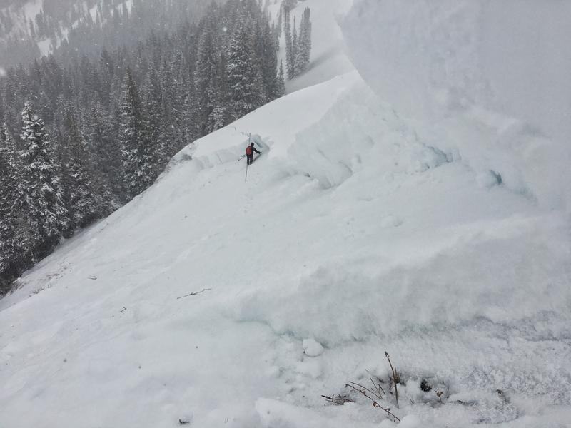
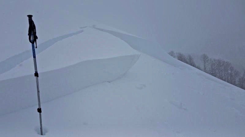
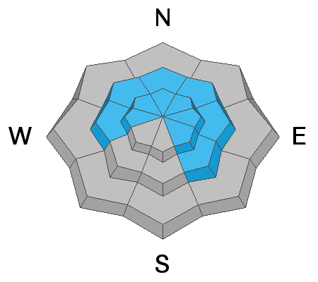
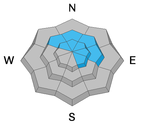
With so much new snow and wind, today has dangerous avalanche conditions. The avalanche danger is HIGH at upper elevations where the combination of new snow, wind drifted snow, and buried weak layers will produce avalanches. With snow falling today and continued strong winds, some avalanches may happen naturally. Avoid being on or underneath avalanche terrain which is any slope steeper than 30 degrees. The avalanche danger is CONSIDERABLE at mid elevations which are experiencing strong winds as well. Avalanches are still possible at low elevations where the danger is MODERATE.
Low
Moderate
Considerable
High
Extreme
Learn how to read the forecast here
Avalanche Warning
THE UAC HAS ISSUED AN AVALANCHE WARNING THIS MORNING THROUGH 6 AM MST WEDNESDAY
FOR THE WASATCH, WESTERN UINTA, AND BEAR RIVER MOUNTAINS.
THE AVALANCHE DANGER IS HIGH TODAY.
HEAVY SNOW AND STRONG WIND IS CREATING WIDESPREAD AREAS OF UNSTABLE SNOW AT UPPER ELEVATIONS. HUMAN TRIGGERED AND NATURAL AVALANCHES ARE LIKELY. STAY OFF OF AND OUT FROM UNDER SLOPES STEEPER THAN 30 DEGREES. TRAVELING IN AVALANCHE TERRAIN IS NOT RECOMMENDED.
Special Announcements
Check out the latest podcast - The Risks and Rewards of Ski Patrol - A Conversation with Jake Hutchinson.
Weather and Snow
There's simply too much water weight, too much wind and too much uncertainty.
Since yesterday morning, the Salt Lake area mountains have received about 10-15 inches of snow containing about 1 inch of water. A lot of the new snow has been graupel snow which are little pellets of dense snow.
Total snowfall since Saturday evening is:
Upper Big Cottonwood Canyon: 4.2-4.9 inches of water (about 38 inches of dense snow)
Upper Little Cottonwood Canyon: 4 inches of water (about 30 inches of snow)
Park City Ridgeline: 2.78-3.5 inches of water (about 20-25 inches of snow)
Temperatures this morning are in the mid 20's F at trailheads and in the mid teens F at most upper elevations. Winds from the S and SW are blowing steady 15-30 mph and gusting 40-60 mph. These winds reaching down into the trees and places typically more sheltered from wind.
Today snow and strong winds will continue with another inch of water and maybe foot of snow possible. Temperatures may warm up by about 5 degrees or so. Tonight winds will shift to the NW and bring more snow and much colder temperatures.
Recent Avalanches
Yesterday Drew and I were descending a ridge on Little Water Peak (between Mill Creek and Big Cottonwood Canyons) and unintentionally triggered a large avalanche that broke at the ground 3-4 feet deep and 200 feet wide. (first photo below)
A skier nearby on "The Cone" triggered a slab of wind drifted snow 2 feet deep and 60 feet wide from 15 feet away (second photo below)
Ski patrols triggered many slab avalanches involving the new snow and wind drifted snow.
Ad
Avalanche Problem #1
Wind Drifted Snow
Type
Location
Likelihood
Size
Description
Southerly winds were transporting a lot of snow yesterday and continued through the night. Fresh slabs of wind drifted snow should be easy to trigger today as more snow falls and winds continue blowing from the south and southwest. What surprised me the most yesterday was how winds were reaching into many areas typically sheltered from the wind. There are few slopes untouched by winds. Today I would be looking for fresh wind drifts on most aspects and elevations and avoiding them.
Avalanche Problem #2
Persistent Weak Layer
Type
Location
Likelihood
Size
Description
There are two persistent weak layers to worry about. One is weak snow near the ground. This layer is most likely to produce an avalanche in places that have avalanched previously this winter (repeater paths). Drew and I unintentionally found one of these slopes yesterday when we were descending a ridge on Little Water Peak. The cornice broke and triggered a large avalanche at the ground. The only way to avoid this problem for now is to avoid riding avalanche terrain generally on the northern half of the compass including some upper elevation SE facing slopes.
While many slopes have a deeper and stronger snowpack, everything has its breaking point. I'm not sure if this snowfall has pushed slopes with a deep and strong snowpack to their breaking point or not yet, but I wouldn't want to find out. It's best to be a little patient.
The second layer is the the snow surface from Saturday that has a combination of small, near surface facets and surface hoar that are now buried 1-3 feet deep by the new snow. This layer will make slab avalanches involving the new snow and wind drifted snow easier to trigger and more sensitive. In many places this layer is easy to spot in snowpit wall as seen below. You can see all the layers in the new snow and the bottom stripe is the weak, faceted layer.
Avalanche Problem #3
New Snow
Type
Location
Likelihood
Size
Description
If you avoid wind drifted snow and stay off the aspects shown above for slopes that may have a buried persistent weak layer, then the avalanche problem to watch for is simply the new snow. It's always hard to know if it will fracture as a slab. The good new is that you can observe how the new snow is reacting on small test slopes. With snow continuing to fall today, I would expect the new snow to at least produce loose sluffs, but it may produce soft slabs about 1-2 feet deep.
General Announcements
This information does not apply to developed ski areas or highways where avalanche control is normally done. This forecast is from the U.S.D.A. Forest Service, which is solely responsible for its content. This forecast describes general avalanche conditions and local variations always occur.