Donate to the 2024 Spring Campaign to help rebuild the UAC website.

Forecast for the Salt Lake Area Mountains

Trent Meisenheimer
Issued by Trent Meisenheimer for
Monday, February 4, 2019
The avalanche danger is CONSIDERABLE on mid elevation west through southeast facing slopes and all upper elevation slopes. Warm temperatures, strong winds and heavy wet snow have created dangerous avalanche conditions. Careful snowpack evaluation, cautious route-finding, and conservative decision making are essential for travel in the backcountry. Avoid steep slopes and avalanche run-out zones such as gullies and couloirs.
The avalanche danger could spike to HIGH during periods of heavy snowfall or increased winds.
Low
Moderate
Considerable
High
Extreme
Learn how to read the forecast here
Special Announcements
Check out a new blog post - The Risks and Rewards of Ski Patrol - A Conversation with Jake Hutchinson.
Weather and Snow
The southerly winds continue to be the headline news in the mountains overnight and through out the day today. Upper elevation averages are in the 15-25 mph range gusting into the 40's and 50's. Overnight the upper cottonwoods picked up another 4-8" of new snow (mainly graupel). It's going to be hard to escape the winds with even the mid elevation anemometers reading speeds in the 15-25 mph range with gusts into the upper 30's.
Yup - it's avalanche weather. The rain snow line will ebb and flow around the 6,000' level today. Temperatures remain on the warm side with upper elevations in the low 20's °F. Rough 36 hr storm snow totals are as follows:
Upper LCC: 16" snow (2.37" h20)
Upper BCC: 25" snow (2.87" h20)
Park City Ridge Line: 8-18" snow (1.0 - 2.1" h20)
Provo Area: 18" snow (3.38" h20)
The riding and turning conditions are excellent if you're in wind sheltered terrain and above about 7,500' where you'll ditch the rain drenched snow and be rewarded with dense, surfy, snow. We will remain in an active storm pattern under a southwest flow for much of the day today. Another 3-6" of new snow is possible with more in favored locations. Tuesday morning/afternoon a trough will slice overhead bringing colder temps and more snow.
Recent Avalanches
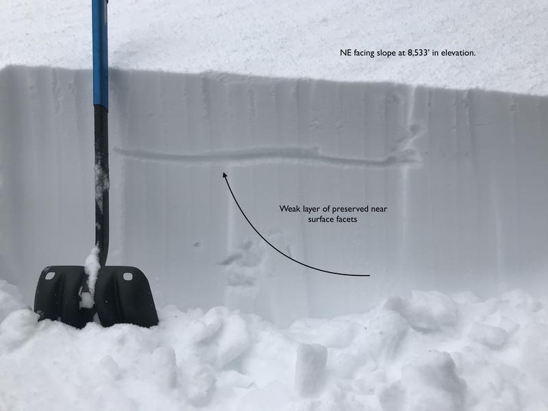
Yesterday, snow safety teams reported the new snow was easily triggered with slope cuts and explosives. These were large enough to bury a human. In the backcountry there was one slab avalanche triggered by a snowmobiler in the Guardsman's area. This avalanche was about 1' deep and 100' wide. It's likely it failed on 
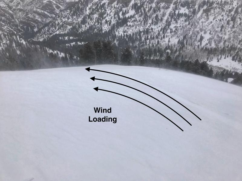
surface hoar. Many observed noted heavy wind loading across ridge lines and cracking. We had 4 or 5 reports of people finding surface hoar / faceted snow just underneath the new storm snow, that was propagating in their snowpit tests.
Ad
Avalanche Problem #1
Wind Drifted Snow
Type
Location
Likelihood
Size
Description
Southerly winds continue to blow with consistent speeds in the 15-25 mph range. This has drifted the new snow onto many leeward (downwind terrain) aspects and elevations just off the ridge lines. As the winds swirl in the mountain drainages and valleys it's also drifting snow and cross loading sub-ridges and mid slope break overs (see pic). On the shadier aspects the wind will drift snow onto weak sugary crystals of faceted snow and or surface hoar making the issue more complicated. Wind loading is a common denominator in most avalanche accidents.
It will be possible to trigger these new drifts from a distance or from below slopes. Human triggered avalanches are likely. For today, avoid steep (greater than 30°) terrain. Especially in terrain that has pillowy, rounded, or hollow sounding snow at all the mid and upper elevations.
Photo: cross loading / wind drifting snow on a mid slope ridge at 8,500' in elevation.
Avalanche Problem #2
Persistent Weak Layer
Type
Location
Likelihood
Size
Description
Over the past week we've seen clear skies and cold temperatures. This has created what we call near surface facets (NSF) and surface hoar (SH). Both of these crystals become a weak layer once we bury it. Yesterday, during my field day I dug four different snowpits at different elevations. In each of my snowpits I was finding this faceted snow just under the 4-8" of new snow. Other observers found surface hoar. In the Guardsman's area a snowmobiler triggered an avalanche that failed on surface hoar.
We need to be very cautious on the steep mid and upper elevation shady aspects and assume that this weak snow is there. As the storm adds more and more weight to this layer it could become a serious problem. For now, it's best to avoid any steep shady terrain until we get a better idea of what this weak layer is up to. In shallow snowpack areas where the snowpack is less that about 5' feet deep it's possible to release a much larger avalanche that breaks deeper in the snowpack.
Photo: Snowpit from Mineral Fork showing the weak faceted snow that I found yesterday.
Avalanche Problem #3
Wet Snow
Type
Location
Likelihood
Size
Description
With the rain/snow line around 6,500’ for much of the night, the wet soggy snow will need time to cool. It will be possible to trigger wet, loose sluffs today on all low elevation slopes. Avoid travel in steep gullies and couloirs, including ice climbs. Even a small wet sluff in a steep terrain trap such as a creek bed or road cut can pile up cement like debris burying you deep.
General Announcements
This information does not apply to developed ski areas or highways where avalanche control is normally done. This forecast is from the U.S.D.A. Forest Service, which is solely responsible for its content. This forecast describes general avalanche conditions and local variations always occur.