Forecast for the Salt Lake Area Mountains

Greg Gagne
Issued by Greg Gagne for
Tuesday, February 26, 2019
The avalanche hazard is MODERATE at the mid and upper elevations for fresh wind drifts. Although any drifts you encounter are likely to be found on aspects facing north through southeast, cross-loading may create drifts on any aspect. Outside of wind-drifted terrain, the hazard is generally Low.
Watch for wet loose activity today on steep southerly aspects as well as the lower elevations.
Low
Moderate
Considerable
High
Extreme
Learn how to read the forecast here
Special Announcements
Weather and Snow
Currently:
Temperatures are starting out a few degrees warmer this morning than yesterday, with low elevation trailheads sitting just below freezing. Mid and upper elevations range throughout the 20’s F.
Strong south/southwest winds remain the dominant weather player. Wind speeds at the mid and upper elevations are averaging in the 20’s and 30’s mph, with gusts in the 50’s above 10,000’.
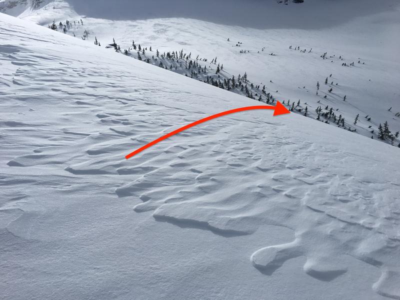
Snow totals in the Salt Lake mountains from Monday vary widely, ranging from 1-6”, but with the strong winds most of this new snow ended up quickly getting transported into fresh wind-drifts. Many exposed aspects facing southwest at the upper elevations have been scoured from the sustained southwesterly winds.
For Today: Temperatures will be warm - into the upper 30’s - and moderate to strong winds out of the west/southwest, averaging in the 20’s and 30’s mph at the mid and upper elevations, with gusts in the 40’s and 50’s. Occasional snow showers may leave an inch or two during the day. Skies will be partly to mostly cloudy.
For This Week: A mild westerly flow with warm temperatures and windy conditions. We may pick up a trace to 1" of new snow every occasional 12-hour period - perhaps up to 2" on Wednesday. A hint of a promising colder storm late Thursday/Friday, but waiting for weather models to come into agreement before we get any confidence in that system.
Winds and warm temperatures have certainly deteriorated ski quality conditions, but there were reports of continued good skiing in wind-sheltered terrain in the mid elevations.
Recent Avalanches
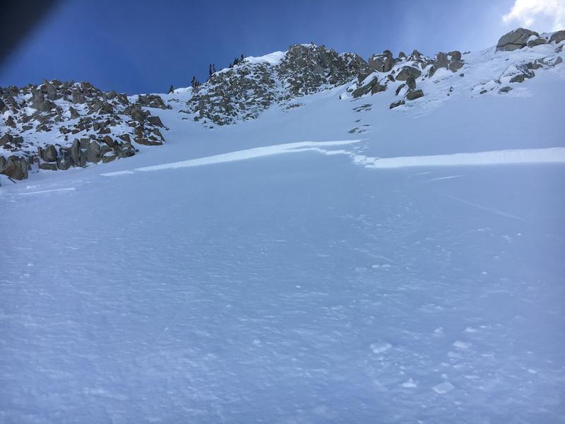
There were reports of a few skier-triggered wind slabs in the Salt Lake mountains yesterday. These were generally on easterly aspects that were wind-loaded from the south/southwest winds. Most of the activity was shallow (< 6"), but Craig Gordon was in the Brighton backcountry and managed to intentionally trigger a fresh wind drift that was 14" thick and 100' wide (observation) [photo Craig Gordon]
We also received reports of minor wet loose activity in the lower elevations as well as damp southerly aspects.
Ad
Avalanche Problem #1
Wind Drifted Snow
Type
Location
Likelihood
Size
Description
West/southwest winds will continue to drift snow at the mid and upper elevations. Although most drifts will be found on leeward aspects facing north through southeast, cross-loading and the winds being channeled through terrain mean drifts may be possible on any aspect at the mid and upper elevations. These drifts will generally be 6-12" thick, and may break out widely in open, exposed terrain, possibly breaking above you.
To read more about the complexity of wind-loading patterns, Drew has an excellent observation from Broads Fork on Monday (link). In particular, note how upper elevation west aspects are wind-scoured, yet those same aspects at the mid elevations are wind-loaded. [photo: Hardesty]
Cornices are quite large, and continue to grow during this windy period. Avoid traveling underneath cornices, as well as anywhere near the edge of ridges as cornices may break back much further than expected. Although now a few days old, it is worth reading this excellent observation from Sunday (link) where the author cautions "Please, stay back from the edge! Even further than you think."
Additional Information
The low elevations are starting out just below freezing, and will warm into the low 40’s F during the day. Winds and cloud cover will help keep the snow surface cool, so I am not expecting much wet loose activity today, but watch for signs of the snow warming at the low elevations as well as steep southerly aspects including rollerballs and wet/loose sluffing, especially if the sun comes out for longer durations.
General Announcements
This information does not apply to developed ski areas or highways where avalanche control is normally done. This forecast is from the U.S.D.A. Forest Service, which is solely responsible for its content. This forecast describes general avalanche conditions and local variations always occur.