Join us at our 2nd Annual Blizzard Ball

Forecast for the Salt Lake Area Mountains

Mark Staples
Issued by Mark Staples on
Tuesday morning, February 18, 2020
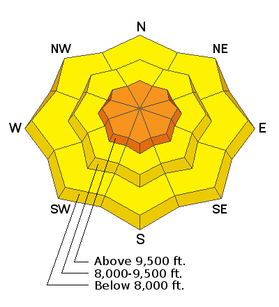
Human triggered avalanches remain likely at upper elevations where soft slabs of new snow combined with fresh wind drifts are the main avalanches problems. In these places the avalanche danger is CONSIDERABLE.
Mid and low elevations generally had less wind, but human triggered avalanches definitely remain possible in the new snow, and the avalanche danger is MODERATE. While conditions are slowly stabilizing, we have enough uncertainty that it's worth being conservative today.
Low
Moderate
Considerable
High
Extreme
Learn how to read the forecast here
Special Announcements
Discounted lift tickets - Thanks to the generous support of our Utah ski resorts and Ski Utah, all proceeds from these ticket sales go towards paying for avalanche forecasting and education! Get your tickets here.
Weather and Snow
Yesterday: Despite strong sunshine in the morning, high temperatures reached teens and low 20s F before increasing clouds and cold air stopped further warming. Due south-facing slopes warmed just enough to dampen the snow and create a very thin crust which may not exist on southwest or southeast facing slopes. Winds remained strong enough to continue transporting snow yesterday and were generally blowing 15 mph and gusting to 30 mph from the northwest. The highest elevations near 11,000 ft had gusts reaching 50 mph.
This morning: It's COLD with temperatures only a few degrees either side of 0 F. Fortunately light winds from the west are blowing 5-10 mph and gusting to 15 mph. A trace to about 1.5 inches of snow fell overnight.
Today: Skies will be mostly sunny with a few clouds. Temperatures will only climb into the teens and low 20s F. Westerly winds should remain light and blow 5-10 mph.
Snowfall from Sunday's storm:
Little Cottonwood Canyon: 15-19” snow (1.50”-1.95” water)
Big Cottonwood Canyon: 12”-23” snow (0.90” - 1.90” water)
Park City Ridgeline: 12-15” snow (1.20” water)
Recent Avalanches
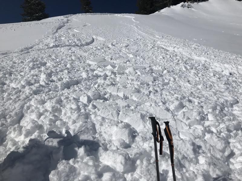
Where to begin? There were many natural and human triggered avalanches yesterday. These avalanches fractured just under the new snow about 8-24 inches deep depending on the amount of new snow and wind-blown snow. Most avalanches appeared to be failing on a layer of very low-density snow that fell at the start of snowfall on Sunday. On many slopes this soft layer rest on top of an ice crust.
Avalanche activity started Sunday during heavy snowfall. Then some natural avalanches occurred very early Monday morning. The ski areas and UDOT triggered many slides yesterday morning and observers triggered more. Today, you will easily be able to spot these avalanches. Check out the list of reported avalanches HERE but there were many more.
Photo of a human triggered slide above Snake Creek behind Brighton. The rider made a hard turn before riding over small steep rollover in otherwise gentle terrain.
Ad
Avalanche Problem #1
New Snow
Type
Location
Likelihood
Size
Description
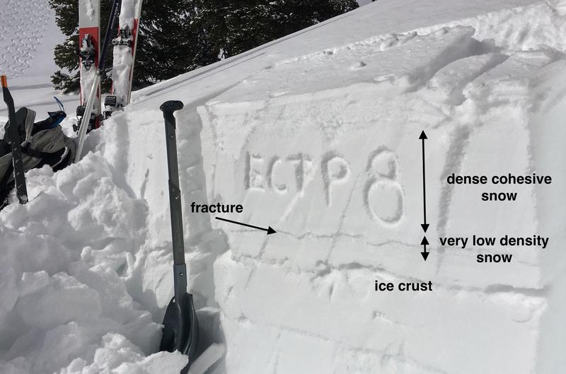
The main avalanche issue is a layer of dense snow resting on a layer of very light and fragile snowflakes. This light snow fell at the start of Sunday's storm and was the weak layer in many of yesterday's avalanches. On many slopes this layer rest on top of an ice crust or other firm layers allowing avalanches to run far.
Normally, weak layers of soft new snow can stabilize quickly. What is unique about layering in the upper 2 feet of the snowpack is dramatic hardness differences. These differences should keep this avalanche issue alive today. You can easily feel these changes in hardness if you dig with your shovel or poke into the snow with a ski pole.
Another issue that may keep the new snow unstable a little longer than normal is the possibility of some weak faceted snow on top of a crust that formed on Feb 7th. I don't think this is a widespread issue, but we have a lot of uncertainty about it and will be looking for it this week.
Photo below of the new snow layering and where fractures are most likely to occur and produce avalanches.

Danger trend: decreasing
Avalanche Problem #2
Wind Drifted Snow
Type
Location
Likelihood
Size
Description
Yesterday winds continued to drift snow and form slabs of dense snow than can easily be triggered today. Winds Sunday night were the strongest with some gusts of 80 mph recorded. You'll mostly likely find these wind slabs at upper elevations, but look for them at mid elevations too. Today's light winds shouldn't be transporting any more snow and will allow these drifts to begin stabilizing.
Winds have mostly been blowing from the northwest and west, but look for drifting on all aspects which can be loaded from the tops of ridges or across the sides of ridges. Visual signs of wind drifted snow include smooth, rounded, pillowly appearances.
Danger trend: decreasing
Additional Information
General Announcements
This information does not apply to developed ski areas or highways where avalanche control is normally done. This forecast is from the U.S.D.A. Forest Service, which is solely responsible for its content. This forecast describes general avalanche conditions and local variations always occur.