UDOT PLANNED AVALANCHE CLOSURES!!

Forecast for the Salt Lake Area Mountains

Drew Hardesty
Issued by Drew Hardesty for
Wednesday, February 15, 2023
Areas of MODERATE avalanche danger exist for pockety soft slabs of wind drifted snow at the mid and upper elevations. Human triggered avalanches are possible. Owing to the northeast winds, look for unusual wind loading patterns.
The best bet is finding wind and sun sheltered terrain today.
Low
Moderate
Considerable
High
Extreme
Learn how to read the forecast here
Weather and Snow
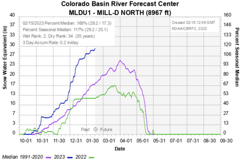
A storm system that primarily affected southern Utah is now barrelling off to the east, keeping us under a cold northeasterly flow. Skies are overcast with a flurry or two lost in the shuffle from the departing storm. We only picked up a trace to 2" overnight, with orographics favoring the Wasatch back. Mountain temperatures are straddling 0°F with 11,000' temps at -6°F. Add in hourly wind speeds at those elevations of 25mph (gusts to 45mph) and wind chill becomes a very real and very cold -33°F. Note that some mid-elevation anemometers are also blowing 15-20mph.
Riding conditions are excellent in the wind and sun sheltered terrain with the two day storm snow of 4-8" sitting on soft settled powder. Solar aspects are bottom feeding; ie: dust on crust.
For today, we'll have mostly cloudy skies, sloowwllyy diminishing winds from the north....and frigid temps in the single digits. Clearing skies by evening with a slow warming trend through early weekend. Another storm looks lined up for later Sunday into President's Day.
Recent Avalanches
Nothing of significance noted from the backcountry other than some minor dry loose sluffing in the new snow. Ski areas reported pockety and stubborn fresh slabs of wind blown snow.

Find all the recent observations HERE.
Ad
Avalanche Problem #1
Wind Drifted Snow
Type
Location
Likelihood
Size
Description
Pockets of fresh soft slabs of wind blown snow will be littered across the compass at the mid and upper elevations. Be on the lookout for drifts with unusual loading patterns, owing to the moderate to strong NE winds. I would anticipate drifts to be more notable on north to west to south facing slopes...with drifts cross-loaded mid-slope. Shooting cracks are indicators of localized instability.
Additional Information
I cherry picked Mill D North's snotel site in mid-BCC to look at how we're shaping up here in mid-February. As you can see, we are well above 'normal' (169%) and way above last year. The medium to long range models keep us in a fairly active weather pattern for the next 7-10 days+.
General Announcements
This information does not apply to developed ski areas or highways where avalanche control is normally done. This forecast is from the U.S.D.A. Forest Service, which is solely responsible for its content. This forecast describes general avalanche conditions and local variations always occur.